Moving Mass

On a grand scale, air masses are set in motion by uneven heating of the Earth’s surface, which causes atmospheric circulation that creates variations in density and pressure.
For example, air near the equator receives more heat from the sun than air at the poles. In the Northern Hemisphere, as the air near the equator warms, its density decreases, and it begins to rise and flow away from the equator toward the north pole. This creates a low pressure area near the equator. Once the rising air cools, it becomes denser and begins to descend, eventually flowing back toward the low pressure area near the equator. The air warms again and the same convection pattern repeats.
The Earth’s rotation causes Coriolis force, which affects the direction of wind flow and counteracts the tendency of air to flow directly from high to low pressure areas.
The spinning Earth influences atmospheric circulation as it creates three convective cells north (and three convective cells south) of the equator. In the northern hemisphere’s northernmost cell, mid-latitude air rises and migrates north to the Arctic, where it becomes a cold, dense, high pressure air mass. This mass moves south, displacing other air masses (and growing warmer) along the way.
TIP: Air temperature, density, and pressure affect aircraft performance. Expect diminished takeoff and climb performance when operating in warm, less dense air and (to a lesser extent) in low pressure areas.
Air in Motion
At a given location, the actual speed and direction of the wind is determined by a combination of three things working together at the same time:
- The strength of the local gradient between high and low pressure
- Coriolis force
- Ground friction
Pressure Gradient

Following the path of least resistance, high pressure air flows toward areas of lower pressure. Dramatic pressure differences between two areas can signify stronger winds.
On weather maps, the letter “H” represents the center of a high pressure area, while an “L” shows the center of a low. Lines called isobars connect areas of equal pressure. Where isobars are close together, differences in pressure occur over shorter distances. Wind tends to be stronger in these areas.
TIP: When you hear words like high, low, warm, and cold, remember that they’re being used in a relative sense. For example, a cold front in the summer typically brings air that’s warmer than a warm front in the winter.
Coriolis Force
The Earth’s rotation causes Coriolis force, which affects the direction of wind flow and counteracts the tendency of air to flow directly from high to low pressure areas. In the northern hemisphere, the Coriolis effect deflects the wind to the right and causes air to flow clockwise around highs and counterclockwise around lows.
Counterclockwise Path—Imagine a high pressure area, sitting next to a strong low. Viewed from above, the strong pressure differential pulls the air to the left, toward the low, while Coriolis force tries to pull it to the right (but with less force). Thus, the air still moves toward the low, but not directly toward it. Deflected by Coriolis force, it follows a curved path—a counterclockwise spiral toward the center of the low.
Dramatic pressure differences between two areas can signify stronger winds.
Clockwise Path—Now imagine the same high pressure area sitting next to a weaker low. In this case, the pressure gradient is not very strong, and even though the air is still being pulled toward the low, the Coriolis force is sufficient to overcome it. So, what happens? Instead of being pulled left toward the low, the air is pulled to the right: It follows a curved, clockwise path around the high.
Dragging the Wind
Ground friction, which increases with proximity to the surface, tends to both slow down the air and counteract Coriolis force. Think of it this way: The air trying to move independently from the Earth causes Coriolis force, but the Earth dragging the air along with it causes friction. Increased friction reduces relative air-Earth motion and lessens Coriolis force.
TIP: Friction from terrain and other obstructions slows the wind near the surface and reduces Coriolis force. You’ll notice that, as you climb to a higher altitude, the wind tends to shift a few degrees and increase in speed.
Highs and Lows
High pressure system—The air in a high pressure system descends and flows outward in a clockwise direction toward the surrounding, lower pressure air. As the air spreads away from the high, air from above descends to replace it. This generally results in light winds and clear skies as the descending air warms and moisture evaporates.
Low pressure system—The air in a low pressure system converges inward and upward in a counter-clockwise direction from the surrounding, higher pressure air. As the air converges it is forced to rise. This generally brings stronger winds, cloudy skies, and precipitation as the rising air cools and the moisture in it condenses.
TIP: The closer you are to the center of a surface low pressure system, the stronger you can expect the wind and any associated weather to be.
Your Location Matters
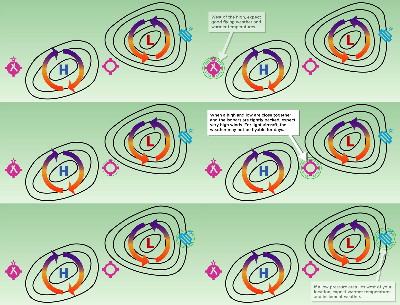
Your location relative to high and low pressure systems can give you an idea of the kind of weather to expect.
- West of a high, you can generally expect good flying weather and warmer temperatures.
- East of a low, expect warmer temperatures and inclement weather.
- When a high and a low are close together and the isobars are tightly packed, you can generally expect very high winds at altitude. For light aircraft, the weather may not be flyable for days.


