 Cold Front Demarcation—Blue line with triangles
Warm Front Demarcation—Red line with half-moons
Stationary Front Demarcation—Alternating red and blue line with a triangle on the blue portion and half-moon on the opposite red portion
Occluded Front Demarcation—Purple line with alternating triangles and half-moons
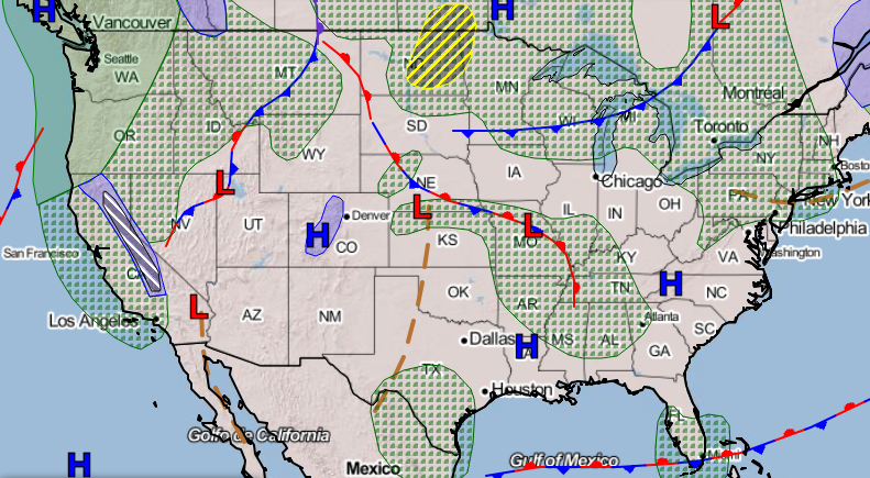
Air Mass Boundaries
A front is the boundary line between two different air masses. The air masses' characteristics and how they move or don’t move determine the type of front. For example, the leading edge of a cold air mass moving toward a warmer air mass is called a cold front.
Winds often converge at frontal boundaries, and temperature and pressure differences can be significant on either side of a front.
Characteristics
Winds often converge at frontal boundaries, and temperature and pressure differences can be significant on either side of a front. So, if a front approaches, you can expect the weather to change. But realize that not every cold or warm front brings the exact same weather.
Fronts are identified by temperature, pressure, moisture, and other factors.
TIP: Cold fronts nearly always extend anywhere from a south direction to a west direction from the center of low pressure areas and never from the center of high pressure systems. Warm fronts also extend from the center of low pressure areas but nearly always on the east side of the low.
Cold Front
When a colder air mass starts to move along the ground, its leading edge is called a cold front. Because the colder, more dense air is heavier than the warmer air it’s displacing, it slides underneath, forcing the warm air to rise. The rising air cools to the dewpoint and forms clouds along the front. Thunderstorms will form if enough moisture and unstable air are present. A fast-moving cold front can also kick up severe squall line thunderstorms along or ahead of the actual front. Cold fronts typically move at 25 to 30 mph, but some can reach 60 mph.
A fast-moving cold front can also kick up severe squall line thunderstorms along or ahead of the actual front.
TIP: In most areas of the United States, cold fronts bring thunderstorms and other severe weather. In drier regions, the lack of moisture inhibits the development of severe weather, and cold front passage typically results in a wind shift and cooler temperatures.
Warm Front
When a warmer air mass moves, the leading edge is called a warm front. Because the warmer air is less dense, it travels up and over the cooler air below. This causes a temperature inversion with very stable, smooth air ahead of the front. If there’s enough moisture in the air, expect widespread stratus cloud coverage, steady rain, and icing in areas that are below freezing. A warm front has a gradual slope over colder air which can extend hundreds of miles ahead of the warm front’s surface position. Warm fronts typically move slower than cold fronts, at around 10 to 25 mph.
TIP: Weather charts only depict the front’s location at the surface. When you fly toward an approaching warm front, you may encounter the warmer, less dense air more than 100 miles from where it is charted on the surface.
Occluded Front
When a faster moving cold front catches up with a slower moving warm front, an occluded front forms. An occluded front can have the weather characteristics of a cold or warm front, depending on the relative air temperature ahead of each front. Hazardous weather is likely if there’s enough moisture in the air.
Cold front occlusion—Occurs when the air associated with a fast-moving cold front is colder than the air ahead of a slow-moving warm front. The cold air replaces the cooler air and pushes the warm front aloft. The associated weather is typically a mixture of both warm and cold front weather.
Warm front occlusion—Occurs when the air ahead of a warm front is colder than the air ahead of a cold front. The cold air is forced aloft by the warm front. The associated weather can be severe if the air forced aloft is unstable.
When air masses have very different moisture levels, the boundary between them is called a dryline.
Stationary Front
When opposing air masses have relatively equal pressure, they stop moving and the line between them becomes a stationary front. Stationary fronts often bring cloudy, wet weather that can last a week or more.
TIP: When planning a trip, watch for stationary fronts forecast along your route. You could get delayed for several days!
Dryline
When air masses have very different moisture levels, the boundary between them is called a dryline. This is common at the narrow boundary found in the Plains region between moist air from the Gulf of Mexico and dry continental air from the west. It is most often present during the spring, where it is often the site of thunderstorm development. Typically, the dryline advances eastward during the day and retreats westward at night. The imbalance of dry and moist air at the dryline can trigger severe thunderstorms and even tornadoes.
TIP: Pay close attention to ATIS and ASOS/AWOS reports ahead when you approach a dryline, as the weather can change quickly.
Frontal Weather Passage Summary:
Cold Front—Gusty winds, turbulence, and thunderstorms
Warm Front—Widespread low stratus clouds, steady rain, and icing conditions
Stationary Front—Cloudy and rainy weather that may last several days
Occluded Front—A mixture of cold and warm front weather that is dependent on temperature
TIP: You can see how the weather is changing by looking at METARs from airports on either side of a front.
Signposts in the Sky
Rough Air