The last stretch
Inadequate planning forces a pilot to ditch in icy waters

The body of water, about 17 miles at its widest point, is the Salish Sea’s primary outlet to the Pacific Ocean, and it represents the maritime border between the far northwest corner of the continental United States and Canada. The Strait separates Washington state’s Olympic Peninsula from Vancouver Island. It’s often traversed by migrating whales traveling between their summer and winter feeding grounds.
On January 26, 2021, the Strait was also the location of a preventable aviation tragedy.
A single pilot, traveling alone in his 1949-model Cessna 170A aircraft that carried the registration N9114A, had begun a multi-day journey in Kodiak, Alaska (PADQ), the afternoon before. His final destination was Lake Havasu City, Arizona (HII), a journey of more than 2,500 nautical miles—and one he had made “many times,” according to his family.
He had about 650 hours in his logbook, of which he had flown 120 hours in the previous 90 days.
The pilot arrived in Ketchikan, Alaska (PAKT), on the evening of January 25, and continued his journey the next morning after filling the fuel tanks. The aircraft was outfitted with two standard 20-gallon wing fuel tanks, and the pilot had modified the aircraft with a third tank in the fuselage. It is estimated that the third tank held about 10 to 15 gallons.
According to the fuelers in Ketchikan, the pilot asked for both wing tanks to be topped off before taking the nozzle himself and topping off the auxiliary tank in the fuselage. All told, he took on 31.9 gallons of fuel that morning. While exchanging small talk with the FBO staff, he mentioned he was flying to Washington state.
The pilot then departed Ketchikan, bound for Port Angeles, Washington, a straight-line journey of 531 nautical miles. His actual flight track, as documented by his InReach satellite communicator, showed a route of more like 545 nm.


He did not file a flight plan or request any other air traffic control services, such as flight following, but kept in touch with his mother via cellphone, exchanging numerous text messages with her during the flight. His track shows that he initially hugged the shoreline of British Columbia before crossing over the narrow Johnstone Strait that divides the mainland from Vancouver Island. The track remains over the eastern portion of the island all the way down to its southern tip.
He texted his mother that he had left Ketchikan with 57 gallons of fuel. That would be enough, he estimated, to make it to William R. Fairchild International Airport (CLM) in Port Angeles on the U.S. mainland and his journey’s northernmost point in the continental United States.
A little more than half-way down Vancouver Island, at about 3:20 p.m. Pacific time and just over five hours into the flight, he suspected he may not have enough fuel after all. He texted, “Nasty headwind, I’m just past Comox not sure if I have enough gas…May land in Canada.”
She replied that she hoped he won’t have to clear Canadian customs just to get gas.
Three minutes later, he wrote, “It got super shitty the last hour.”
At 3:41 p.m., the pilot texted that he had been in the air for 5.7 hours, with his GPS telling him he had another 1.1 hours to go to reach Port Angeles. He estimated that with a fuel burn of between 6 and 10 gallons per hour he could still make it to his destination.
He texted his mother, “It’s a tough call, it should make it…but these headwinds have got me going slow.... There’s a bunch of clouds I’m trying to skirt as well.”
She responded, “Sounds like a nervous combination,” and calculated that had he burned an average of 8.38 gallons per hour, that would “get you there on fumes.”
“I’m unhappy about it, already went through over an hour of really bad turbulence,” he responded.
Just after 4 p.m., his mother asked for his ETA in Port Angeles, as she was watching the airport webcam to see him land.
 About 10 minutes later he said that he had about 29 minutes to go. But “it keeps changing…I’ll be doing 90 knots then cross a peak and suddenly 60…Turbulent again too…lots of clouds.”
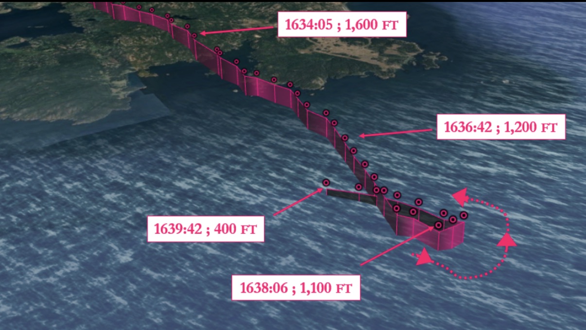
Radar data shows that he overflew the coast of Vancouver Island, on the northern side of the Strait of Juan de Fuca, at approximately 4:34 p.m., aiming to cross the body of water at one of its narrowest points where it was just 10 miles across. He was on a southerly track and traveling at 1,600 feet. Two minutes later, he had descended to 1,200 feet, and two minutes after that, he was at 1,100 feet.
This was when he decided to reverse course. The radar data shows that the aircraft was just six miles from land to the south, and four miles from land to the north, when the pilot made a 180-degree turn to the left, to head back toward Canada.
At 4:39 p.m., he sent his mother a photograph showing a marine vessel towing a barge in the water below and to the east of his location. It shows several landmarks, including Washington’s Mount Baker and Race Rocks, an outcropping about one mile from Vancouver Island. The pilot put out a mayday call on Port Angeles’ unicom frequency, stating he was ditching into the water.
Another pilot answered him: “One-Four-Alpha, how far north of the shoreline are you?”
“Right in the middle, I’m out here by…there…there’s a boat going by…there’s a tanker getting drug. I am out in the middle, and I’m going down now. I’m going in the water.”
The other pilot asks, “Are you east or west of the Coast Guard station at Port Angeles, if you can tell me?”
“I don’t know, [indiscernible] water…I’m right by this boat…there’s a boat…there’s a boat getting towed by a barge. I’m going in the water now.”
According to the NTSB’s final report, the last radar data received from the aircraft showed it was flying at 400 feet and descending about 500 feet per minute toward the northwest. The last ping showed it about 2.9 miles from the southern coastline of Vancouver Island.
Shortly thereafter, U.S. and Canadian authorities launched an extensive rescue effort that included search and rescue aircraft from both countries as well as numerous ships and fishing vessels in the area. After two days and an operation covering an area of about 1,100 square miles, the active search was suspended. The aircraft and its pilot were never found.
Another pilot answered him: “One-Four-Alpha, how far northof the shoreline are you?’’
“Right in the middle, I’m out here...there..there’s a boat going by...there’s a tanker getting drug. I am out in the middle, and I’m going down now. I’m going in the water.”
Analysis
The NTSB determined the cause of the crash to be a total loss of engine power caused by fuel exhaustion, resulting from “the pilot’s inadequate in-flight fuel planning.” And indeed, a few times before ditching the aircraft into the frigid water, the pilot had mentioned in text messages to his mother that he didn’t know if he’d have enough fuel to make it to Port Angeles, given the weather conditions he encountered on his journey.
It’s also unclear if the pilot knew exactly how much fuel he had on board. The Cessna 170A model has two 20-gallon fuel tanks in its wings, but only 37 of those 40 gallons are usable.
As for the auxiliary tank in the fuselage, the NTSB noted that there are two modification options under supplemental type certificates (STC) available for that aircraft type, but aircraft documents “did not [indicate] either were installed.” Adding a fuel tank for long-range operations is considered a “major alteration” that requires STC approval from the FAA. Nevertheless, the NTSB report assumed that the third tank likely had a capacity of 10 to 15 gallons. That would mean the pilot would have had somewhere between 47 and 52 gallons available, rather than the 57 that he purported to have.
Along the east side of Vancouver Island there was ample opportunity to land. The pilot’s flight path took him almost exactly over airports in—from north to south—Comox, Qualicum Beach, and Nanaimo. At the latest, when approaching the southern tip of the island, he could have diverted to Victoria International Airport, just a few miles off his left wing. However, the pilot chose to press on across the strait despite the inclement weather and the strong winds he was experiencing.
Perhaps one of his motivations to continue to U.S. soil at all costs was British Columbia’s province-wide state of emergency that was still in effect at the time because of the COVID-19 pandemic. He likely wanted to get to his destination without delay and avoid dealing with the consequences of an unplanned landing in Canada. Those could have likely included bureaucracy, paperwork, and possible quarantine or other health-related measures. His mother had also mentioned “customs” issues if he would have stopped for fuel.
Correct fuel planning is integral to any flight, and critical when attempting a multi-day, cross-country flight in unforgiving conditions over hostile terrain and stretches of open water like this pilot was. The fact that the pilot had done it “many times” according to his family, perhaps led to complacency. He appeared to have grossly miscalculated the effects of the sometimes-harsh winter weather and strong January winds.
Fuel exhaustion, meaning there is no more fuel on board the aircraft, and fuel starvation, meaning there is fuel somewhere, but it isn’t available to the engine(s) for any one of many reasons, are among common causes of numerous accidents every year.
According to the AOPA Air Safety Institute’s thirty-fifth Richard G. McSpadden Report, published in November 2025, in the eight years between 2016 and 2023 (the last year for which full statistics are available), 726 aircraft crashed because of fuel-related issues, most of which were attributed to fuel exhaustion or starvation. Of that number, 76 accidents were fatal.
Even if he had made it to Port Angeles, the pilot may have been in violation of the FAA-mandated reserve fuel planning requirement of 30 minutes for a daytime VFR flight. A 550-nm journey on 57 gallons of fuel (or 52 or 47 gallons) in an 80-year-old Cessna 170 is a stretch on a good day, in ideal conditions and with perfect leaning techniques. Even if the pilot had had all of those, he would probably still have arrived in Port Angeles “on fumes” or close to it.
Learn more about how to prevent fuel-related accidents at:  airsafetyinstitute.org/spotlight/fuelmanagement
Fatigue, and the errors of judgment that result from it, could also have played a role in this accident. He was flying the final miles of a day-long journey, about half an hour before sunset, under what from the image he took appeared to be an overcast sky.
“Of course, the last stretch is a water crossing,” the final text to his mother read. 
Related Articles


