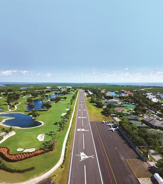
An overlooked Caribbean island
Same regs, better scenery


Airliners heading in and out of San Juan Airport/Luis Munoz Marin International Airport (SJU) fill the radio frequencies, and the fact that they’re making visual approaches gives a strong hint that the weather also is clear at nearby Isla Grande Airport (Fernando Luis Ribas Dominicci Airport; SIG), the busiest general aviation facility in Puerto Rico. Air traffic controllers switch back and forth between English and Spanish effortlessly, but most transmissions are in English.
Puerto Rico as a flying destination is overshadowed by its more exotic neighbors. The U.S. and British Virgin Islands are close by, and the eastern Caribbean is within easy reach. But Puerto Rico is a haven for U.S. pilots, with airports large and small, gorgeous tropical scenery, outdoor and water sports, a long and colorful history, vibrant Latin and Caribbean culture, and an English-based aviation system—all at relatively low costs with few paperwork hassles.
“I’ve flown all over North America, Europe, and the Middle East, and home is hard to beat,” said Tommy Hill, founder of air charter company ProPilot, who grew up in Puerto Rico and flies aircraft ranging from helicopters and floatplanes to corporate jets here. “We’ve got lakes in the mountains that are ideal for floatplanes, a wide variety of airports, and spectacular coastline.
“We’ve got long runways that were built by the military as well as short fields that are every bit as challenging as St. Bart’s” (the hillside airport on the Caribbean island St. Barthelemy infamous for its plunging, terrain-hugging approach).
Getting there
Puerto Rico is a long way from South Florida, about 900 nautical miles when following the airways. Getting there means going over the Bahamas and the Turks and Caicos and flying parallel to the far larger islands of Cuba and the Dominican Republic. Yet pilots can be in radio contact with Miami Center all along the route before contacting San Juan Center about 100 miles out.
On this winter day, the island’s mountainous outline comes into sharp relief about 30 miles away, and billowy clouds and rain obscure the highest peaks. Yet ATIS confirms the sky is clear at Isla Grande where 10-knot, midmorning tradewinds favor landing on Runway 9.
Descending to 2,500 feet keeps you clear of clouds while crossing the palm-lined beaches on the island’s surf-pounded north shore. ATC provides a vector to join a 10-mile final approach to Runway 9, then a frequency change puts you in touch with a tower controller at Isla Grande.
The scenery ahead is mesmerizing: San Juan harbor with its historic Spanish fort on a tall bluff near the mouth; white cruise ships, yachts, and fishing boats dot the harbor; the old city sits on a peninsula; and high-rise apartments surround the waterfront.
Runway 9 is straight ahead, well-marked, and unobstructed, yet boat traffic, flocks of seagulls, and pelicans require some last-minute maneuvering. The runway is 5,539 feet long, and its threshold is a few feet from the water’s edge.
Turning off the runway just beyond midfield puts you at the U.S. Customs ramp, and it’s located next to Modern Aviation FBO, a full-service facility that’s a launching pad for GA flights throughout the region.
The island of Vieques is about five miles off the east end of Puerto Rico, and its nontowered, 4,300-foot-long, east-west runway (VQS) is well aligned with prevailing winds. Vieques is known for its beaches, abundant sea life, and relaxing atmosphere. In addition to GA aircraft, the island is served by a pair of commuter airlines.


The U.S. Navy used the east end of the island for bombing practice, amphibious landings, and ship-to-shore bombardment for decades. That stopped in 2001, however, and a multimillion-dollar cleanup followed. Large portions of the island are now a wildlife refuge (see “Vieques, Puerto Rico,” AOPA Pilot, October 2022).
A few miles northeast, the island of Culebra (CPX) has perhaps even more natural beauty—and its paved, 2,600-foot runway is among the most difficult in the region.
“Fly the notch between the two hills on approach [to Runway 13] but be careful how low you go,” a pilot commented on ForeFlight. “Even under relatively nice conditions, the winds can be squirrely. Be prepared to go around.”
On the eastern tip of Puerto Rico, the former Roosevelt Roads U.S. Navy base (RVR) has a massive, 11,000-foot runway suitable for the largest transport aircraft. It’s close to the ferries that take visitors to Vieques and Culebra for those who choose not to fly to the smaller islands. There are two FBOs and a U.S. Customs office on the airport.
Humacao (X63) is a haven for sport aircraft on the east coast of Puerto Rico. Airport fees are far less than in San Juan, the biggest city in Puerto Rico, and Humacao is a place pilots like to hang out and congregate. Light sport aircraft, Piper Cubs, and other recreational aircraft predominate at the 2,458-foot airstrip.
Ponce on the south coast is the second-largest city in Puerto Rico, and the airport known as Mercedita (PSE) has an 8,000-foot runway. It’s close to the coastal town of Salinas which is known for seafood restaurants. Salinas is a favorite for seaplane pilots who tie up at the docks for a seafood lunch.
Mayaguez on the west coast is an increasingly popular vacation and retirement spot for Americans. They’re drawn by the expansive beaches, relatively low cost of living, and laid-back vibe. The nontowered airport (MAZ) has a 5,000-foot runway and is close to water taxis to nearby islands. Mayaguez is an airport of entry, and it’s a relaxing beach vacation spot. Avoid the restricted airspace to the south, however, where a tethered, radar-equipped balloon monitors air and water traffic throughout the region.
Rafael Hernandez Airport in Aguadilla (BQN) on the northwest tip of Puerto Rico is a popular place for arrivals and departures to clear U.S. Customs. The airport has a massive, 11,700-foot runway, both VOR and RNAV approaches, and price competition between the two FBOs there (Copeca Jet Center and Western Jet Center) has given the airport a reputation for consistently offering the lowest fuel prices in the region. Also, because there’s relatively little conflicting air traffic, turbine departures are often cleared to high altitude almost immediately, and that decreases fuel consumption and increases range.
Coming and going
Airplanes that fly nonstop between the mainland United States and Puerto Rico are treated as domestic flights, so there’s no need to go through the eAPIS customs clearance process or land at an airport of entry.
For those who plan to make intermediate stops, Exuma International Airport (MYEF) in the Bahamas and Providenciales International Airport (MBPV) are easy places to refuel and clear customs. The longest over-water portion of the route between the U.S. mainland and Puerto Rico is usually the long leg between the Turks and Caicos and Puerto Rico. It’s almost 500 nautical miles, although Cuba and the Dominican Republic are possible emergency diversions.
The U.S. Customs facilities in Puerto Rico are known for being efficient and friendly, but there are a couple of potential gotchas. First, be absolutely positive that you phone them in advance to let them know your estimated time of arrival. Failing to call in advance can lead to fines, even when eAPIS flight plans are properly filed online. The regulations still require a phone call, so make the call.
Also, don’t show up with uneaten snacks or drinks in the airplane. Those may be regarded as dangerous items in need of specialized disposal, and something as nonthreatening as a peanut-butter sandwich can lead to hundreds of dollars in disposal fees.
Flights between Puerto Rico and the U.S. Virgin Islands also don’t require eAPIS, and they can be made under less cumbersome VFR regulations.
Also, on departure from Puerto Rico, the U.S. Department of Agriculture is required to inspect each airplane before flying to the U.S. mainland. Those inspections are free on weekdays between 8 a.m. and 4 p.m., but weekend or after-hours callouts involve hefty fees, so plan accordingly.
Pilots flying to Puerto Rico from the east on IFR flight plans are often routed over the mountainous top of the island where afternoon weather tends to be stormy and turbulent, but there are alternatives. Ask for a transition around the east end of the island well in advance and you may get routed over the top of San Juan International where the weather is typically clear.
There’s also a “low, offshore” route that involves descending to 500 feet or less and following the coastline. You can even cancel IFR and fly that scenic route along the northeast coast (and check the surf along the north shore at the same time).
Finally, tropical weather is characterized by frequent and sometimes intense rain showers, particularly in the summer months. If it’s rainy at your destination airport, the best strategy can be slowing down, or holding in an area of good weather before proceeding to your destination or diverting.
“In the corporate jets, we strongly prefer landing at Isla Grande,” Hill said. “In all my years of flying in Puerto Rico, I’ve never had to land at the big airport [San Juan International] due to weather. Being willing to simply hold for 10 or 15 minutes is enough. The rain moves on, your destination airport clears out, and you land in sunshine.”
Hill is bilingual but he said U.S. pilots who don’t speak Spanish shouldn’t be intimidated.
“English is the international language of aviation, and it works just fine in Puerto Rico,” he said. “My dad came to Puerto Rico in the 1950s and he lived here for decades without ever learning to speak Spanish. Same with my mom.”
“Speaking Spanish is nice, but it’s not necessary, especially in aviation. We’re under the American flag here, and the regular rules and regulations that pilots are accustomed to on the mainland apply here as well. The main difference is that the scenery here’s a lot better.”


