In a Cub above islands in the European sky
Swiss autumn photography weekend
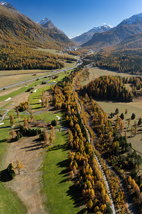
Larch trees typically reach their peak of color for only one weekend in late October, when a long weekend of flying from the highest airport in Switzerland revealed stunning scenery.

Engadin Airport (elevation 5,600 feet, also known by the name of the mountain village it serves, Samedan) had been circled as a destination since 2018, when I was working on a project photographing the peaks over 4,000 meters in the Alps. Samedan, near the resort town of St. Moritz, had provided a convenient fuel stop. Perched in a deep valley north of Lake Como, Italy, Samedan’s natural beauty quickly made an impression. I fell in love with it while descending into the circuit, an attachment that only grew once I landed. It was positively a divine mix of Pyrenees and Colorado air and blue sky.
I was able to view them by air in 2019 in that section of Switzerland during the autumn, though that trip was cut short by a nasty storm. The pandemic year was a bust, and 2021 presented the hard decision to board a commercial flight to Norway and buy a Super Cub instead.
Finally, in 2022, I was geared up to spend a long weekend flying from one of the highest airports in Europe (Courchevel Airport in the French Alps is at 6,588 feet). There is a requirement to take an online course and carry the results on any flights into Engadin Airport; I was already current from previous flights. The airport is in a very tight valley with some interesting winds, as described during the online course.
Larches change in mid-October, and the colors last until early November. I was watching webcams and thought that it was still a bit early, though I decided that it was better to be early than to miss the season. The chosen weekend came, with iffy weather for the crossing of the Alps.
Reckoning with Samedan


I must confess that I get neurotic every time I fly to Samedan. To date, I had only made the trip in the PA–11 Cub Special, and it would be so again as the Super Cub was in the shop. I had flown to Samedan in the middle of summer many times for the 2021 flights documenting the glaciers of the Alps. At 109 nautical miles as the crow flies, it should not be a harrowing prospect with 18 gallons of fuel. While many pilots would hesitate to operate a Cub in such terrain, I spend most of my time in the air over and among large mountain ranges. Something about this particular flight makes me nervous—and was tormenting me.
At the halfway point, there is a convergence of four ranges and high passes that I call the “crown of the Alps.” It isn’t the highest point; there are certainly much higher mountains elsewhere. It is where the Alps seem to come together and where the low crossings are highest. The passes tend to be windy, though nothing I am saying is unique to this part of the Alps. I do find that, for a trip to be successful from western to eastern Switzerland in the Alps, it should be a better day than normal, as the large expanse of territory means that more weather is taking place than just a local flight.
In any case, I agonized over the decision to book a hotel and undertake the flight. The day before, it appeared like some lingering weather would blow out and everything would be fine, so I made the reservation. The morning of departure came with a less optimistic forecast, though it was VFR and was expected to improve. I decided to make the trip to the Obergoms and to the north side of the ridge separating the Italian- and German-speaking sections of Switzerland. “It will be fine,” I told myself. “Quit being a drama queen.”
As I cleared 7,000 feet over Rüwlispass in the Bernese Oberland, I was greeted by light rain showers that were not on radar and overcast blocking more of the Bernese Alps ridge than webcams had indicated. I continued toward Gemmipass, getting accelerated through at 9,000 feet with some sprinkles, a roaring tailwind, and not too much room above.
Blowing over the ridge toward the Rhône valley, I was greeted with more rain showers and marginal VFR conditions, which were neither forecast nor showing up on observations. Sion was a viable alternate per the METAR, so I decided to see what awaited around the bend. The original flight plan was now out the window, and I was making it up as I went along.
Reaching Brig, it was painfully evident that the Obergoms and crown of the Alps region was entirely socked in with overcast down below the passes and rain again, none of which was materializing on radar nor forecast.
I decided to check out Simplon Pass, knowing that Locarno and Engadin Airports were still reporting VFR conditions. Once I crossed the pass to the south side, there would likely be no going back due to strong north winds.
The pass was barely open, with evidence of sun at the Italian border, so I made a go for it, wedging through yet again with a roaring tailwind, getting blown out the other side. What I saw before me on the other side confirmed that maybe, just maybe, every time I take this flight, it is complicated. I had to climb 1,500 feet to 10,000 feet msl to get above a relatively persistent cloud deck. To my left, the ridges of the Alps, where I had originally intended to fly, were impenetrable. Straight ahead was a sea of “islands in the sky” as various ridges stuck out above the cloud deck. Observations still said VFR in both places, so I continued eastbound, flying VFR on top in the Alps until I got north of Lake Como, where it was evident that I could get into the valley without too much complication.
As is normal, the flight ended up being 2.5 hours to make the 109-nm hop, because of various deviations, plus enjoying the beauty of the trees for a while. I fueled, had some lunch, and hopped back in the airplane for another local flight.
After some valley frolicking, the sun started to cast harsh shadows in that deep valley. I wandered around the base of the Morteratschgletscher at low altitude, something I hadn’t done before, then aimed for 12,500 feet to enjoy the ridgeline of Piz Bernina and other glaciated peaks. It was rather windy, quite cold, and modestly menacing as rainfall continued to stream from the northwest toward the Austrian border. The views with sunset light of the glaciers were extraordinary.
Will fly for color


The next day, I opened the curtains of the hotel room with great anticipation and instead was met with something of a horror outside: The valley was socked in with ground fog. At breakfast, the locals confirmed that it only happens the day after rainfall, and it should clear quickly. Thankfully it did, leaving a picture-perfect day in its wake: bright blue skies, incredible larch colors, and little wind. As I was preflighting the aircraft, a Super Cub was being used for instruction, which topped off an otherwise perfect morning.
I decided to take off to the southwest to look at the cloud deck that was receding toward Italy. The view of mountains above the clouds was interesting as always. I turned to the northwest over Julierpass, for the first task of the day: I wanted to check out the larches in the neighboring valley where Davos is located. I had flown through the valley once in late spring, and it appeared to have plenty of trees. As I crossed Bivio toward Albula, Schmitten, and Davos, I found the larch results a bit disappointing. Terrain was naturally picturesque, though larch density was low and often only on the north-facing slopes. Wandering my way around some of the idyllic valleys south of Davos, I found the same to be true, so I decided to head back toward the Engadin, via Flüelapass.
At the summit of the pass, the neighborhood Super Cub flew by in the other direction. We would often hear each other on the radio during the weekend, as the airplane was kept busy instructing.
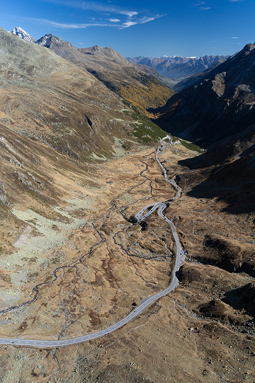
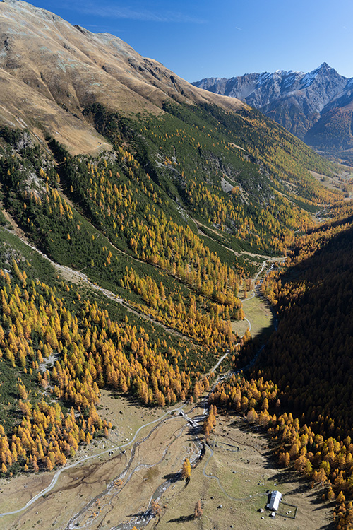
After cresting the pass, I followed the contour of terrain lower down into the trees, where the larches exploded into color. Reaching the valley of the River Inn, I had a choice to make: Turn right toward Samedan, or left toward Austria? Given that the lighting favored higher altitudes, I turned right toward Zernez and Samedan, flying back and forth across the valley, working my way up each side valley until forced to turn around.
It was a nonstop exercise of box canyon flying, with a primary concern that I didn’t encounter gondola cables. While they are marked on the map, there are plenty of them used in forestry and agricultural operations, aside from larger installations for skiing. One drawback of my navigation software is that it “sees through” mountains and projects my flight path, warning about cables that might be a mile away, though literally through a mountain. It results in frequent false alarms, so one must keep a good lookout. Thankfully, the PA–11 is a docile and slow aircraft that turns on a dime, so I spent a good hour at low cruise speed, flying at about 7,000 feet, right at the larch tree layer, taking stupendous photographs.
I continued past the airport and back into the low valleys of the Morteratschgletscher and Tschiervagletscher. While I had frolicked the night before, it was shadowed and had broken clouds, whereas today was in the peak of brilliant midday light. I was hoping to capture the tongues of these sizable glaciers and, to the extent possible, include some larch color in them. I was rewarded on both fronts, treated to a very personal experience with these specific glaciers that I had not enjoyed before.
After a fuel stop and a sandwich, I was back in the air in the early afternoon, this time to wander a bit into Italy to see what I could find. The flight path was to Berninapass, over Forcola di Livigno at the border, then to what appeared from the air to be the resort town of Livigno. It was an interesting sight: mountains that looked positively like they were out of Colorado, high altitude vegetation a golden brown because of the time of year, and oddly placed larches in full bloom. It could have been mistaken for an out-of-body experience in Montana, Colorado, or Wyoming. In any case, it was an exploration process as I was flying, as Google Earth does not distinguish trees by their species. In some places, it was vibrant larch color. In others, it was green pine.
I continued to the southeast toward Bormio, though I found a similar phenomenon as I did from Bivio to the north: The larches abruptly cease, along with the brilliant colors. I turned southwest at San Carlo, over the uninhabited Pass da Val Viola and back into Switzerland. I already knew that the larches live in a narrow band in the Alps, and that reality was getting confirmed the more I explored. I decided to use the remaining fuel on that tank to cross near the airport and turn west toward Malojapass. With brilliant sunshine and afternoon tones, the air work continued in each box canyon adjoining the main valley until fatigue and lower fuel set in.
I hadn’t decided if I would fly a third time that day. The thought of a luxuriant dinner at the hotel, with a wood-fired pizza oven that I could sit near (and warm up), was proving to be a temptation. It was also brilliant early evening light. “You’re here, go flying,” I said to myself, rationalizing that the pizza oven would be crackling just as well after dark. Cold and a bit tired, I took off again, heading southwest to get the last light before shadows closed off the trees near Malojapass. Then I ascended toward Piz Bernina again, for a cameo performance of the prior night. Lighting and the views were world-class above 12,000 feet as the sun began to set, leaving me forgetting for a moment how cold and tired I was.
Windy Way Home


The next day was time to return. The forecast was full sun, which was a welcome change from the eastbound flight. Yet again, I found myself a bit nervous. “Why all the drama?” I asked myself, attempting to rationalize that I had taken plenty of 2.5-hour flights the previous day through thick terrain. How could this be different? As I approached Andermatt, I was reminded why things are usually complicated. A crosswind became a headwind, which was not forecast. The wind in the Alps is more likely to bend and twist down valleys than to necessarily stay with the ambient flow aloft, which means that a south wind can be a west wind for a while, or vice versa. Andermatt also tends to have quite a bit of wind, with observation stations to confirm it.
Cresting the “crown of the Alps” at 11,000 feet, the winds had turned south again, finding an exit over Grimselpass. I was presented with the choice of a west/southwest path down the Obergoms, or to take the tailwind to the north side of the Bernese Alps. I opted for the Obergoms, as there were a few larches below, and the light was gorgeous.
The flight crossed the base of the Aletschgletscher, the longest glacier in the Alps, and skirted the southern edge of the Bernese Alps, before crossing again at Gemmipass, this time without any clouds. The moderate headwind that was causing some concern near Brig turned into a roaring tailwind before landing at Saanen on an otherwise tranquil day in the autumn.
Larch trees can be found in several places in the Alps. They are prominent in the Valais, in sections of Italy near Aosta, and further in the Southern Alps in France. I know they continue east into South Tyrol, Italy, and likely to some extent in the Dolomites. I would have preferred the Super Cub to cover more territory, though 12 hours over three days in the air was enough. There is always next season to continue exploring.
Related Articles


