WX Watch: Hurricane Encounters
Leave it to the experts
 But now is also a good time to review what has been this year’s noteworthy Atlantic hurricane season. At this writing in early October, there have already been 15 named tropical storms and 10 hurricanes, of which five were major—meaning they had winds of 137 knots or higher. The worst damage was caused by the devastating major hurricanes Harvey, Irma, and Maria.
Most pilots steer well clear of hurricanes, of course. But there are some exceptions. The U.S. Air Force flies its 10 beefed-up WC–130J aircraft right into hurricanes to gather readings essential to forecasting a storm’s path and intensity. The National Oceanic and Atmospheric Administration flies its Lockheed WP–3D Orions and Gulfstream G–IVs on similar missions.
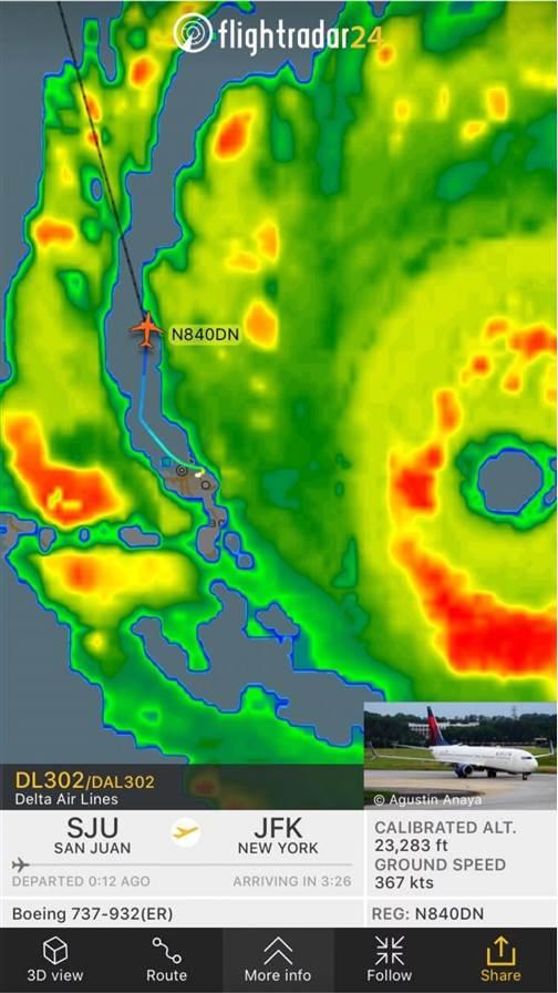
Civilian flights into tropical storms and hurricanes? Why even think of it? And yet, on September 6, Delta Air Lines chose to dispatch a scheduled flight from New York’s John F. Kennedy International Airport to San Juan, Puerto Rico. It arrived as hurricane Irma was approaching the east coast of Puerto Rico. Apparently, Delta’s meteorologists were convinced that safety wouldn’t be compromised. The Boeing 737-900ER landed in San Juan after flying through turbulence that the captain said “wasn’t even bumpy until we got close.” Visibility for the landing was nine miles in light rain, with surface winds of 28 to 36 mph.
A Delta statement said that the company’s meteorology and dispatch offices “were prepared for heavy wind shear, crosswinds, strong tailwinds, but it was no worse than a summer thunderstorm in Atlanta.”
Once at the gate, the airline crew did a 40-minute quick-turn, loaded up with 173 passengers, and then launched back for JFK as Flight 302. Eight minutes later, the San Juan Airport was closed.
 Wx24Pilot
Delta has its fancy flight weather viewer app, and now there’s yet another new weather app aimed at general aviation pilots. It’s Wx24Pilot ($39.99 from the App Store). The iOS app is heavy on the visuals, showing color-coded weather symbology along the route of flight; circular airport weather symbology that shows both color-coded and textual weather for selected airports; and plots that let you customize the displays to show your personal minimums. It’s worth checking out, but better read the tutorial first to understand all its functions. —TAH
How did Delta pull it off? Real-time coordination between flight crew and the meteorology and dispatch offices, sharing of turbulence data via Delta’s proprietary flight weather viewer app, and imagery from the airplane’s own onboard weather radar led the list of decision-making aids. It also didn’t hurt that Flight 302 flew in the gaps between the rain bands surrounding Irma’s outer perimeter. Still, it all sounds a tad risky. Outer rain bands can bring tornadoes with them.
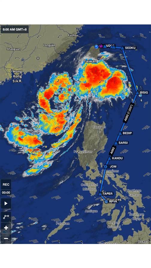
Meanwhile, on the other side of the world, I ran into some tropical weather of my own on September 1. I had been ground-bound with an Air Journey tour group in Taiwan for three days, waiting out tropical storm Mawar. Its huge cloud mass hadn’t budged, but a plan was hatched to take off from Taipei’s Songshan Airport, fly through what looked like a soft spot, and make a wide circumnavigation to the east around the storm. Weather for takeoff was wind 90 degrees at 13 knots, five miles in rainshowers, with cloud layers of 1,500 scattered, 2,500 scattered, and 9,000 overcast. Not too bad, but shortly after takeoff our Cessna Citation Mustang ran into torrential rain while climbing through 15,000 feet. It was so bad I wondered if the engines would flame out—but the single bout with turbulence wasn’t that bad. The engines didn’t flame out, and we broke out between layers starting at about 28,000 feet. By 36,000 feet we were on top and all worked out well for the rest of the trip. I won’t do that again, and suggest you follow suit—no matter what kind of airplane you’re flying. The next day Mawar’s surface winds peaked at 50 mph.
Warming runways
Once back home, I read a New York Times article by Mike Ives titled “Climate Change Lands at the Airport.” The thrust of the piece was that global warming could threaten many airports. Rising sea levels would inundate low-lying airports built near seacoasts or river beds. Thawing permafrost would damage runways in northern latitudes. Rising temperatures would require longer runways to cope with the effects of high density altitude, and payloads would have to be reduced to preserve safe climb rates.
Whether you believe global warming is achieved by man-made influences, or is a part of natural cyclical patterns, this year’s especially violent Atlantic hurricanes make you wonder: What will next year bring?
Email [email protected]

Related Articles


