Runway Visual Range
What to expect when flying an ILS approach
By Rob Mark
An instrument approach in instrument conditions normally ends in one of two ways: Either the pilot flying visually spots enough of the runway environment to safely land the aircraft, or they don’t. If not, a missed approach is the only option. FAR 91.175 (d) 2 stipulates that no pilot “may land an aircraft when the flight visibility is less than the visibility prescribed in the standard instrument approach procedure (IAP) being used.”

To be clear, flight visibility should not be confused with ground visibility. Flight visibility is how far a pilot can see from the cockpit. Ground visibility, however, must be calculated by a certified weather observer on the ground.
Most airports sport several ground-based visual aids like approach and runway lights, precise runway surface markings, and runway end identifier lights to create every possible opportunity for the flying pilot to safely complete a touchdown. Busy commercial airports often include another valuable tool known as a runway visual range (RVR) system that precisely measures the distance a pilot flying an ILS approach might expect to see when looking down the runway in those critical seconds just before touchdown. An RVR is typically installed in conjunction with the runway that offers the lowest landing minimums. As traffic has come roaring back since the pandemic, an RVR is considered a critical element to moving large numbers of airplanes in poor weather.
The RVR plays another important role in demands made by some cockpit crew members during takeoff in poor visibility conditions. The word “some” here is important because while aircraft operating under Part 91 are legally allowed to depart in zero-zero conditions or shoot the approach in any weather, aircraft operating under Part 121 or Part 135 are unable to even begin the approach if the weather sinks below landing minimums, except when the airport employs an RVR that provides the most accurate visibility measurement for takeoff and landing.
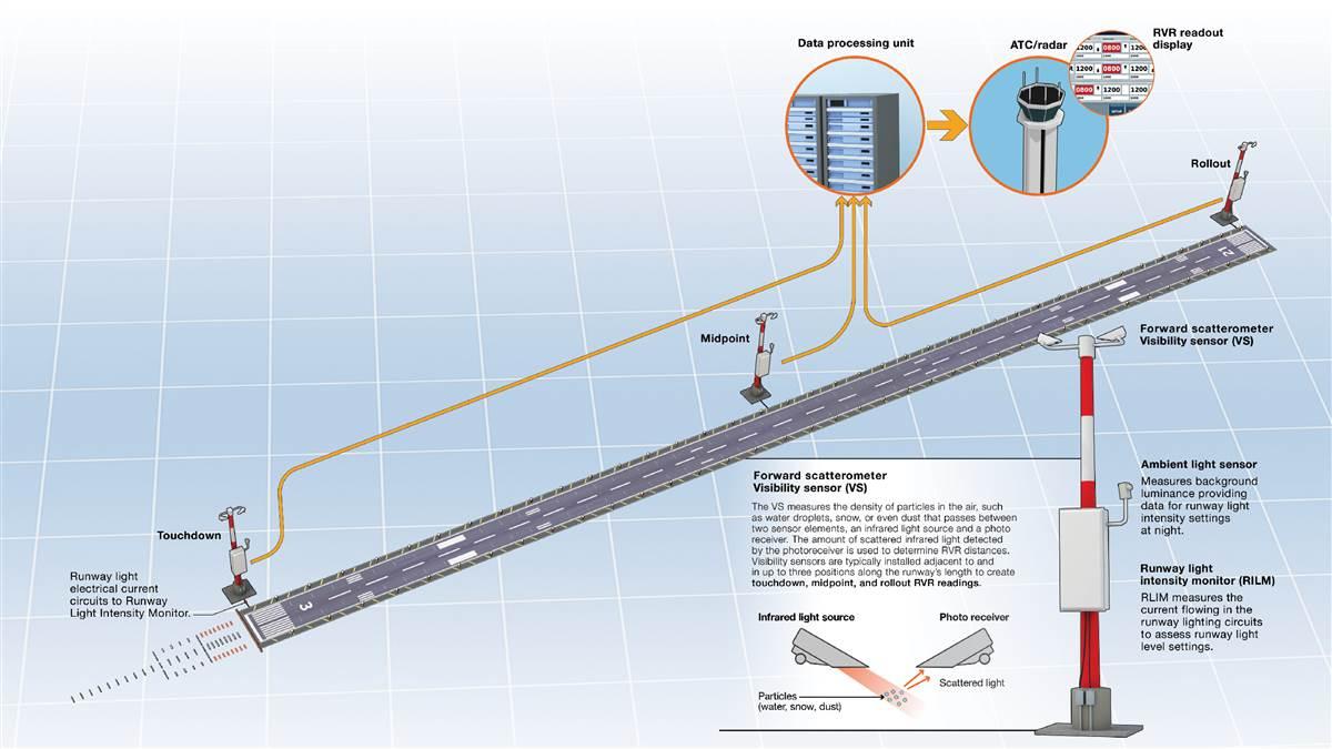
As traffic has come roaring back since the pandemic, an RVR is considered a critical element to moving large numbers of airplanes in poor weather. A typical RVR system is built around elements including a visibility sensor, an ambient light sensor, a runway light intensity monitor, a data processing unit, and a control display unit. RVR units are also connected to an airport’s automated weather surface observing system to capture and broadcast additional data points as they’re generated. The most advanced RVR visibility sensors (VS) now use a forward scatterometer that includes a projector and a photo receiver attached to a pole, placing the electronics approximately 10 feet higher than the runway surface. The VS measures the density of particles in the air, such as water droplets, snow, or even dust that passes between the two sensor elements, consisting of one that creates a beam of light aimed at a second receiver some distance away to create data points that are translated into a usable RVR measurement. Visibility sensors are typically installed adjacent to and in up to three positions along the runway’s length to create touchdown, midpoint, and rollout RVR readings. Although these visibility measurements are captured at only three points along the runway, the data they create have proven to accurately represent the visibility over the entire landing surface. One additional RVR element, the ambient light sensor (ALS), interprets the impact that background lighting, such as nearby runway lights, might have on the overall visibility measurement. All the data gathered is then fed into the RVR’s computer to generate the RVR measurement pilots are familiar with.
From a practical perspective, RVR readout displays are normally located in both the control tower and the radar room where air traffic controllers can regularly update pilots inbound on an approach or departure. For example, when clearing an aircraft for takeoff, the tower controller might announce, “Falcon Two-Three-Nine-Zulu, Runway Two-Two Left RVR one thousand six hundred, cleared for takeoff,” which translates into a touchdown distance of roughly one-quarter of a statute mile. It’s the pilot’s responsibility, of course, to adhere to the takeoff minimums that apply to their flight.
As a reference, the lowest authorized ILS minimums, with all required ground and airborne systems components operative, are: (a) Category I decision height (DH) 200 feet and RVR 2,400 feet (with touchdown zone and centerline lighting, RVR 1,800 feet); (b) Category II, DH 100 feet and RVR 1,200 feet; (c) Category IIIa No DH or DH below 100 feet and RVR not less than 700 feet; (d) Category IIIb No DH or DH below 50 feet and RVR less than 700 feet but not less than 150 feet; (e) Category IIIc No DH and no RVR limitation.
A quick look at the minimums box on the Runway 22 Left ILS at JFK, for example, indicates that with the proper aircraft equipment, the pilot of a Part 121 aircraft may land if the flight visibility is at least one-half statute mile, also equating to an RVR of 2,400. Without an RVR system, approaches to minimums less than a half mile are not possible. For cockpit crews trained and certified for Category II or III ILS operations, and with the addition of items like touchdown zone and centerline lighting, the crew may land when the RVR is as little as 600, approximately one-eighth of a mile. In the best, or worst case depending upon how a pilot looks at the data, a crew certified for Category IIIc approaches can land in weather in actual zero-zero conditions. A typical landing clearance at the RVR-served airport during poor weather might sound like this: “Falcon Two-Three-Nine-Zulu, Runway 22 Left cleared to land, touchdown RVR one thousand eight hundred, midfield one thousand two hundred and rollout one thousand eight hundred.”
Rob Mark is an aviation journalist and the publisher of JetWhine.com.


