Rivers in the sky
Watching atmospheric rivers slam California
Of course not, as anyone who has logged any time flying there can readily attest. Sunny beaches? Not along the coastline, at least when high pressure’s sinking, warming air runs into the cooler, low-level air above offshore cold currents. As the warm air aloft runs into cold, drops in temperature create a low-level stratus layer that can cause widespread instrument conditions. This marine inversion layer may be just 1,000 feet deep, but ceilings are often as low as 500 feet—lower in northern California in the winter months. This layer burns off with the heat of the day, and typically dissipates by late morning. But until then, instrument meteorological conditions are the rule. Typically, a clearance to 1,000 feet or more lets you pop up to clear skies, and you’re on your way.
California also has plenty of high terrain that can create turbulence, icing, and mountain obscuration. Expect strong, gusty, shifting winds at any high-elevation airports.
Then there are the strong Santa Ana winds—named for the Santa Ana River in the San Bernardino Mountains that live in Southern California. We’ve all learned that high pressure systems generate clockwise-flowing winds, and low pressure means counterclockwise flows. Let’s say we have a center of high pressure located east of Los Angeles, and a low parked somewhere the Imperial Valley in extreme southern California. There’s a pressure gradient between these two systems, and that’s what sends high-speed air to the west, through mountain passes, and into Los Angeles and neighboring communities.
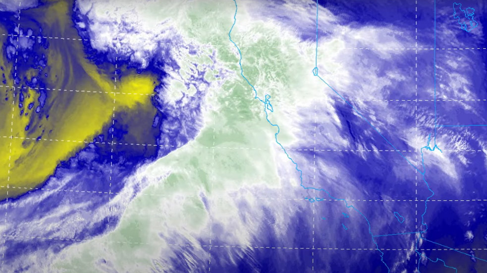
. The darker the shades, the more the water suspended in the atmosphere. I looked at this to see the trend as our trip to Joby manufacturer in California approached. As you can see, the remnants of the last “river” are still over central and northern California. I was hoping against hope that that tongue of yellow and red (the darker the shades, the more the moisture transport) would hold off long enough to provide a gap for our visit three days later. Alas, it was not to be. The second view is from February 1, 2023; now you can see that a surface high off the California coast is blocking the rivers to the west, keeping them on headings to Alaska and the equatorial region. Center for Western Weather and Water Extremes.")
A big high can have an impact of its own, but when a high and a low adjoin each other, watch out. Wind speeds will be much higher than those from a single, lonesome high, and can reach 100 mph. Because Santa Ana winds blow from high terrain to low, they warm as they flow westward and descend.
There’s more, of course. San Francisco and Los Angeles have their own microclimates, thanks to their geographic peculiarities. Dry conditions coupled with strong winds create fire weather that result in flight exclusion zones in high terrain. Many airports are located right along the coast, so there are sea breezes to deal with. And some airports are wedged into valleys or put in deserts, where it can easily hit triple-digit temperatures in the summer.
This year, California got a taste of yet another semi-permanent weather phenomenon: what have come to be called “atmospheric rivers.” California gets its rainy season in the winter months, and this year’s procession of heavy rain events were mainly caused by high-altitude dynamics with origins in the North Pacific.
Simply put, these “rivers” are caused by especially long bands of jet stream winds at altitudes ranging from 5,000 to 30,000 feet. Jet streams mark the boundary between polar and subtropical air and create low pressure centers and their associated fronts. Like all fronts, they’re influenced by the geography around them. In this case, a literal ocean of water. The jet stream picks up all this water, which then is transported eastward according to the undulations of the upper-air patterns. It’s a lot of water, on the move.
Meteorologists scan the North Pacific looking at satellite or computer models with bands 1,200 statute miles long and 600 or so miles wide bearing high moisture signatures. When these bands take aim on California, get ready for lots of rain and a massive number of airports to experience bouts with instrument meteorological conditions. In the last big atmospheric river event, between December 26, 2022, and January 17, 2023, San Francisco International recorded a total of 15.28 inches of rain, Santa Cruz, 36.18 inches, and Oakland, 18.33 inches.
As luck would have it, AOPA Pilot staffers got slammed by a January 11, 2023, inundation while reporting on Joby’s JS4 (see “Coming to Your Airport in 2025?” p. 50). January 11 was the day we arrived at Joby’s headquarters at the Marina, California, airport (OAR). Not only would there be no flying that day, but when checking into the hotel in nearby Monterey the hotel clerk advised us that we were under a flood watch.
The next day was better, but as it turned out we had to scrub the air-to-air photography and come back after the “river” effects had indeed subsided.
Want to watch for atmospheric rivers? Check out the National Center for Environmental Prediction’s integrated vapor transport website (cw3e.ucsd.edu/ivt_iwv_npacific).

Related Articles


