Mountain pass charting changes coming
Two newly charted mountain passes will appear on Alaskan flight charts this March to help pilots plan and navigate routes across the Brooks Range while another pass in the area is being considered for removal.
These changes are the result of a joint effort between industry and the FAA to improve the information available to pilots flying in mountainous regions. While this effort is currently focused on locations in Alaska, future changes are in the works for mountainous regions across the country.
Background
Flying through mountain passes can be a challenge, especially in unfamiliar terrain. Studying flight charts to select a route is an essential element of preflight planning for any flight, but when navigating through confined mountainous terrain, it is particularly important. One critical aspect is knowing the location of any relevant passes, which represent the highest points pilots have to cross before anticipating lowering terrain ahead. Knowing the elevation of these points is also valuable information. When clouds and ceilings are a factor, determining the minimum altitude needed to comfortably fly a route through a pass is an important parameter. The inability to maintain that altitude long before approaching the pass is a good indicator that you should consider an alternate route—or retreat while you still are able to turn around.
Newly charted passes
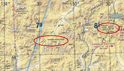
On the March 24, 2022, chart cycle, pilots will find Naqsralugiaq Pass in the central Brooks Range. This pass is well known by locals as it offers a much safer route across the central Brooks Range than Atigun Pass. Only 22 nautical miles west of Atigun, it is more than 1,000 feet lower in elevation and located in much less confined terrain. While Atigun Pass has a road and pipeline leading to it that make it easy to find, due to its higher elevation and precipitous terrain, it has been the scene of numerous fatal accidents over the years. Adding Naqsralugiaq Pass to the Fairbanks and Point Barrow sectional charts will hopefully encourage pilots to consider another alternative when crossing the central Brooks Range.
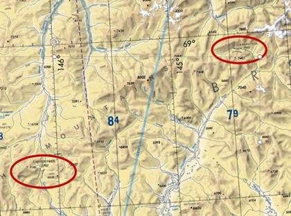
The other pass added during this chart cycle is Carter Pass, in the eastern Brooks Range. This pass is also well known to pilots who routinely fly in this area. It supports a route between the Marsh Fork of the Canning River to the north, with the Chandalar River drainage to the south. Carter Pass provides a much more direct route than Guilbeau Pass, which is more than 40 miles further east and almost 1,000 feet higher.
Removing a mountain pass
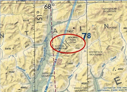
The working group addressing these issues was also tasked with considering removal of unsafe mountain passes. While examining this area, the group identified Holmes Pass. This pass is also in the central Brooks Range, is relatively high, and has a much lower terrain route around it. Based on the experience of the working group, it is not used by local pilots. It was originally identified as a pass in 1930 by Robert Marshall, who traveled the area by dogsled. A request was submitted to remove this pass from aeronautical charts. The FAA is currently circulating a public notice inviting comments on this proposed change. If you use this pass and think it should remain on the charts, please review this notice, and advise the FAA of your use of this chart feature.
More change is ahead