A dive into cold fronts
Where cold air and warm clash


All of them—cold, warm, stationary, and occluded—have their dangers when it comes to lowered ceilings and visibilities, turbulence, and icing in the colder months, but somewhere out there must be an analysis of which fronts are more often implicated in accidents. I’m betting on cold fronts. Warm and stationary fronts generally affect larger areas and move slowly. Warm fronts typically move at a blistering 10 to 15 knots, if that, and stationary fronts, well, as the name implies, don’t move much at all. Maybe five knots on average. They tend to languish for as much as a day or two—or until another system comes along and blows them apart. Same thing with an occluded front. The adverse weather associated with these slow-movers can cover several states, and generally moves to the north and east. These fronts are well-advertised in forecasts, so experienced and current instrument pilots flying more capable airplanes are more likely to take them on. Day-VFR pilots know enough to stay away.

Of course, in the summer months cold fronts are apt to produce thunderstorms, and the gust fronts, outflow boundaries, squall lines, and icing that can precede them. In worst cases, tornadoes can occur. These happen when upper air patterns create the right amount of wind shear to allow low-level air columns to rotate and become ingested into supercell thunderstorms. For all this mayhem, it’s a thunderstorm’s turbulence that often causes accidents—because of in-flight breakups.
As for flying near cold fronts bear in mind the warnings to maintain visual separation (a minimal standoff distance of 20 nautical miles is most often mentioned) from building cumulus and cumulonimbus clouds, slowing the airplane to maneuvering speed in turbulence to minimize structural overloads, avoiding abrupt control deflections, and making a 180-degree turn to exit any sketchy-looking conditions. Next to visual avoidance, Doppler weather radar imagery, datalinked into the cockpit via SiriusXM Aviation weather or FIS-B, is one of the most useful tools for avoiding storm cells. Just be sure to give any heavy precipitation returns or contouring cells a wide berth; datalink is best used for strategic avoidance and decision-making—it’s not meant for weaving your way through a front or other convective situation with tightly packed cells. We’ve all heard much of this advice from the earliest days of our flight training—but they bear repeating.
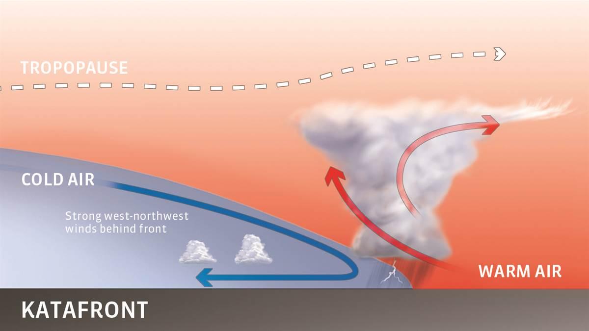
Conventional information leaves you with a single impression of a cold front and its behavior. It’s boisterous, with cold air aggressively pushing broad masses of cumulonimbus clouds and storm cells ahead of it, in angry lines, clusters, or large-scale, organized mesoscale systems. That description fits most cold fronts, especially in the depths of summer in the warmer parts of the United States. Meteorologists call these katafronts. Katafronts have strong temperature contrasts across their frontal boundaries, and upper-level winds that cross them at an angle and energize their dynamics. There is often sinking air behind them, which means that clearer skies follow the frontal passage.
The other type of cold front is called an anafront. They occur when there’s less of a temperature contrast across the front (which makes them more common in the colder months), and upper winds flow more parallel to the frontal boundary. They have rising air on the cold, postfrontal side of the frontal boundary, move slower than katafronts, and tend to produce stratiform clouds and precipitation. Still, they’re no picnic because, like katafronts, thunderstorms can still form ahead of the frontal boundary—just not as often.
You may wonder why the area ahead of a cold front is so conducive to convective activity. Recall that fronts exist in pressure troughs, which usually radiate from a parent center of low pressure, and that there’s a low-altitude wind shift as you cross a cold front. The advancing cold air commonly blows out of the west or northwest, while winds out of the south or southwest fill the warm sector ahead of the front. This explains why you need to adjust your heading to crab to the right when you cross a front.
Those warm and humid southerly winds ahead of the cold front can intensify for hours before the cold front bears down on them. Temperatures and moisture levels skyrocket as they ride the trough’s pressure gradients and pack in the heat, causing what’s called a thermal ridge—a northward projection of maximum heat that’s fertile ground for frontal convergence and lifting forces to create thunderstorms. Stand on a ramp ahead of a midsummer cold frontal passage and you may well notice sharply rising southerly winds, temperatures, and mugginess in the hour before the fireworks begin.


