Flying into a bowl
Helena, Montana’s ILS Z Runway 27 approach

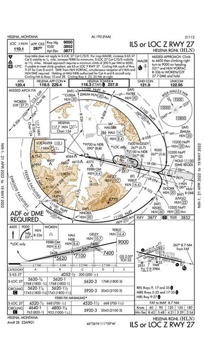
Helena Regional Airport (HLN) sits in a bowl, surrounded by high terrain in almost every direction. The field sits at an elevation just shy of 3,900 feet msl, which in and of itself is not a huge deal. However, the terrain only a few miles away reaches higher than 8,700 feet msl. The highest minimum safe altitude is 10,800 feet.
An initial look at the chart can be overwhelming, as it is loaded with information. The Notes section is long, and it includes a cold weather temperature correction notation. Back in the day, one of the things that would have made this approach a challenge is the DME arc. DME arcs can be difficult because the direction of the wind constantly changes relative to your position and heading. On the off chance that you would need to do this approach without a GPS and with an old-fashioned VOR needle, you will be busy as you balance the acts of managing the arc itself along with altitude and airspeed while working your way around to the final approach.
If you have a functional moving map and GPS and an autopilot, you need to make sure complacency doesn’t set in, because the terrain still represents a real threat.
I’ve done this approach in both visual and instrument conditions. In IMC, you are taking it on faith that all the information is accurate and the technology will work as advertised. In VMC, you will get a stunning view of the valley and an appreciation for just how accurate that technology is. You may also wish you were in IMC just so you wouldn’t have to see how foreboding the terrain is.
What is difficult to appreciate when looking at the chart is just how well the arc follows the terrain. Along most of it, you are limited to 11,100 feet, so if you’re in a piston aircraft, this already may be taxing the limits of your airplane’s performance. Inside the 058 and 103 radials off the VOR, you can descend to 10,200 feet until joining the localizer. In a jet or a turboprop, this is no big deal, but with a piston engine or two, you may be busy juggling props and mixtures as you descend into thicker air.
If you come into Helena in IMC in the winter, you will also need to be cognizant of ice no matter what you’re flying. In either VMC or IMC, you also need to be prepared for turbulence, but especially in visual conditions with an unstable air mass in the area.
Because of the valley, fog can also be a concern, so pay attention to the weather reports before you go. If you need an alternate, make sure it is within a reasonable range and will not produce the same issues of the sort presented by Helena.
However, once established, the approach is straightforward, save the higher altitudes, which will lead to higher groundspeeds. The missed approach, on the other hand, requires attention to detail, as it calls for a rate of climb of 300 feet per nautical mile to 6,000 feet. This isn’t a big deal at sea level, but at higher elevations or density altitudes, it matters—especially if you’ve picked up any ice along the way.
Chip Wright is an airline pilot and frequent contributor to AOPA publications.


