VFR Unleashed: Are we allowed to do that?
Part Four of a multi-part series on expanding our horizons as VFR-only pilots
I used to have enough fear of marginal VFR conditions that I would never embark on a trip without perfect 10-mile visibility and stable cloud layers more than 4,000 feet agl. That was probably a great personal minimum for a brand-new private pilot but is ultimately unrealistic for someone wanting to go farther. Unless a trip happens to fall into one of those rare, “severe clear” high-pressure systems dominating most of the nation, odds are that somewhere on a long cross-country trip, marginal conditions will exist.

A few years ago, I had an important trip scheduled that would take me 567 nautical miles from Maryland to Illinois in a Cessna 172. It was in the high heat of summer, but the forecast was completely clear all the way across the seven states I would traverse on my 5.9-hour flight. There wasn’t supposed to be a cloud in the sky. Easy trip, right?
A thick layer of unforecast clouds was sitting along the eastern edge of the Appalachian Mountains near Petersburg, West Virginia. The AWOS at Grant County Airport was reporting broken clouds at 5,000 feet agl. With the airfield elevation of 963 feet msl, and the mountain range just to its west topping out at 4,770 feet msl, some quick calculations would suggest that I had roughly 1,200 feet of clearance between the cloud bases and the mountainous terrain.
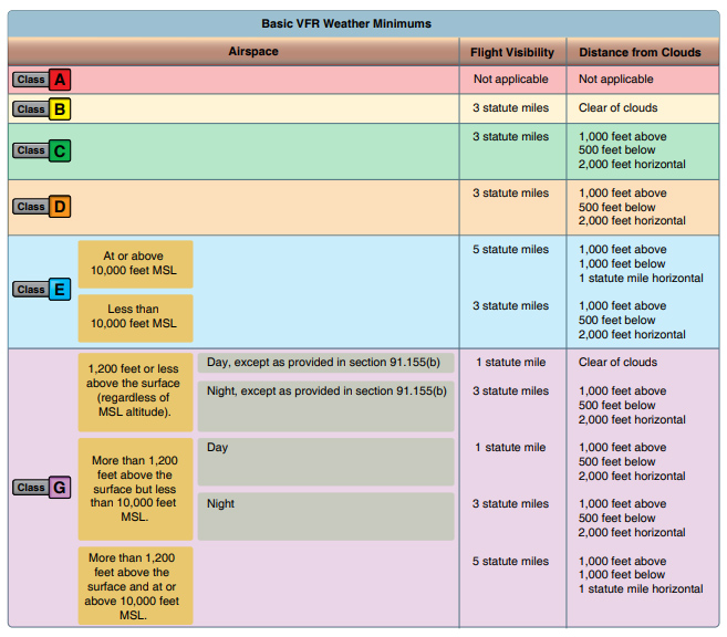
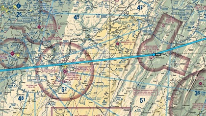 According to the regulations, it would have been legal for me to fly the route. The surrounding airspace was Class G, meaning if I stayed below 1,200 feet agl and navigated around some Class E airspace near Elkins, I only needed to remain clear of clouds, unlike the requirement to stay 500 feet below the clouds in other airspace. Further tempting me, the VFR sectional chart indicated a maximum elevation figure for that quadrant of 5,200 feet msl, meaning I could easily fly above any charted obstacles and stay well below the clouds.
Hopefully you notice there is a lot of math here. While the detailed equation did result in a technical justification for the route, just because it is legal doesn’t mean it is safe or wise.
There are some serious problems when we’re tempted to run this kind of math to find the narrowest margins for VFR flight. Cloud bases are rarely perfectly uniform. They were nearly 6,000 feet msl over Grant County Airport, but that does not mean they would be so 20 miles to the west. Heading deep into the Appalachians, I was facing 35 miles of wilderness, multiple mountain peaks, and no alternative landing spots. If conditions deteriorated, there would be no way out.
 A much better solution to crossing the mountains would be a 120-mile detour, where I would first head 40 miles northeast—the opposite direction to my destination—and then turn west where the ridges were only 3,000 feet high, several small airports were nestled in the mountains, and there was a major interstate I could follow for both situational awareness and emergency landing options.
I am glad I made that choice.
Including a fuel stop, it added two hours to my trip. When our VFR travels are tied to some other agenda, there can be genuine pressure to continue a trip to keep commitments we’ve made to other people. In this case, as I chose safety over efficiency, it meant that I would miss the evening meeting I was aiming for in Illinois. But as I crossed the Appalachians near Garrett County, Maryland, the six miles of hazy visibility and uneven layers of broken clouds confirmed for me that crossing mountains in marginal conditions is no joke.
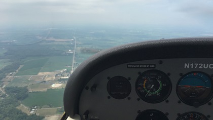
For the rest of the trip to Illinois the forecast was just as expected, with only a few clouds in the sky. But when I climbed to my planned 6,500-foot-msl cruising altitude to try to beat the blazing temperatures near the surface, I found forward visibility in haze and humidity that might as well have been a solid bank of clouds. There was no discernible horizon, and the glare of the harsh sunlight made spotting traffic impossible. The flight may have been technically VFR, but it was clearly not visual flight in any practical sense.
 So, down I went to slog it out all the way across the Midwest for the next 450 miles at 2,500 feet. It was not fun. It was bumpy. I measured a scorching 90 degrees inside the aircraft. By the time I made it to Illinois, my planned 5.9-hour flight had evolved into nearly 9 hours of grueling effort.
An instrument rating would have certainly made the trip straightforward, on-time, and more comfortable with much cooler cabin temperatures. But a VFR certificate still got me there with a little more work and some careful decision making. Oh, and that meeting I missed? We rescheduled it, and it happened the next morning just fine.
I learned one really important lesson about the rules regarding clouds and visibility: Just because I am allowed to do it doesn’t mean I should.