In case of emergency
It’s a big world out there. Flight plans help rescuers find those in need.

Its concept is simple: Tell someone where you’re going, how you plan to get there, and when you expect to arrive. That way, if you don’t show up, the cavalry can be dispatched.
Flight plans are filed, opened, and finally closed. The filing is simply the creation of the plan. It can be filed the old-fashioned way with a phone call to Flight Service; by using a computer to file one online with the same folks; or by using an aviation app such as Garmin Pilot or ForeFlight as an intermediary. Once you are ready to go, or in the air, you open—or activate—the plan by phone, radio, or perhaps by simply tapping a button in an app. You close the flight plan on arrival at your destination. If you don’t close your plan at the other end because of an off-airport emergency landing or crash, searchers will know two things: Where to start looking for you, and the fact that they need to look for you in the first place.
Flight plans minimize the time to your rescue by getting the fastest possible jump on the search and rescue efforts. Yet the FAA’s General Aviation and Part 135 Activity Survey showed that in 2018 only 30 percent of VFR hours were flown with a flight plan. That number is down from 56 percent in 2012.
Why did so few pilots file? And why are the numbers dropping? The original numbers may be simply attributable to the independent I-don’t-have-to-talk-to-anyone pilot personality, perhaps fueled by fear of hostile encounters with authority when forgetting to close a flight plan (we all have). But the decrease in flight plan filing may be related to changes in technology, which is ironic given that technology has also made filing, opening, and closing flight plans easier than ever before.
Many pilots today feel that a cluster of new technology and options keep them as safe—or safer—than the old-fashioned flight plan. Instead of filing, they rely on their airplanes’ emergency locator transmitters (ELTs), portable personal locator beacons (PLBs), GPS trackers, smartphones, flight following, or Automatic Dependent Surveillance-Broadcast (ADS-B) transponders.
So how’s all that working out? Is it time to just fold up that old flight plan and use it as a paper airplane?
The ELT
The story of the ELT is the story of two airplane crashes. The first was the 1967 crash of a Cessna 195 with Alvin Oien, Phyllis Oien, and Phyllis’ 15-year-old daughter, Carla Corbus—who turned 16 while awaiting rescue—on board. The pilot had filed a flight plan, and the trio all survived the crash. But they were never located by searchers. The father died of exposure while trying to hike for help. The mother and daughter hung on for 55 days before finally succumbing to starvation, all the while chronicling their ordeal in a series of letters recovered when deer hunters stumbled across the wreckage seven months later.
Publication of a portion of the mother and daughter’s diary in newspapers galvanized the first ELT legislation, which was given a second push by the 1972 disappearance of a pair of U.S. congressmen in the Alaskan bush (who, to this day, have never been located). The result of these crashes was that Congress required all aircraft in the country be equipped with 121.5 MHz ELTs to make locating downed airplanes easier. Later, satellite technology was used to “listen” for ELTs, which were designed with spring-loaded switches to automatically activate upon detecting an impact.
But expectations exceeded technology, and the ELT system was plagued with both a high false alarm rate and failures to work properly when needed—the first generation activating less than a quarter of the time in actual crashes. And although most of us are still required by the 1970s legislation to have them in our aircraft, the satellites that listened for the beacons were turned off in 2009. Airliners still monitor 121.5, as do many GA pilots, but relying on a 121.5 ELT as your primary safety tool is a bit like counting on winning the lottery as part of your retirement planning.
That said, a new generation of ELTs using GPS technology on the 406 MHz band also meets regulatory requirements, and these units come closer to fulfilling the original promise of the ELT. Newer 406 ELTs are monitored by satellite, activate far more reliably than 121.5 models, transmit more accurate location information, and relay vital information specific to an aircraft. But they are more expensive, and many older aircraft—which describes most of the GA fleet—are not retrofitted, and probably never will be.
Instead, many pilots rely on a readily affordable “pocket” version of this technology called a personal locator beacon, or PLB.
Personal locator beacons
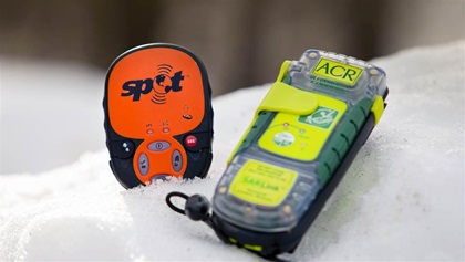
Lots of pilots now carry PLBs, small GPS transmitters than can send a Mayday signal to the swarm of satellites when activated, pinpointing your location with astonishing accuracy.
But there’s a problem.
This is what you trained for: At 3,000 feet your instructor reaches over and pulls the throttle back to idle, announcing, “Your engine just failed.” You establish best glide speed, pantomime trying to restart the engine, and pull out your emergency checklist. While you scan the terrain around you for the best landing spot—hmm… the farmer’s field or the country road?—you pretend to change the radio to 121.5 MHz and, without pressing the mic of course, make your Mayday call. Then you simulate entering 7700 into your transponder to alert air traffic control to your location.
But at remote airfields, an engine failure after takeoff or landing accident may leave you seconds, not minutes, to react. There isn’t time to activate the PLB, and it doesn’t activate automatically as an ELT should.
GPS trackers
A technology related to the PLB, but one that’s always on the job, is a GPS tracker such as the Spot satellite GPS messenger. These devices have a button that can be pressed to send a mayday signal like a PLB, but the trackers also automatically broadcast their location as often as every two and a half minutes. Without manually activating the mayday signal, however, someone outside the airplane needs to know when the flight is supposed to arrive at its destination; if it’s delayed, look up the track info online; and then report that information to the authorities. Sort of a friends and family flight plan.
 Unless, of course, you filed a flight plan online through Leidos’ Flight Service website (1800wxbrief.com), and you have registered your Spot with Leidos. In that case, search and rescue is activated when your tracker stops moving, rather than when your flight plan is overdue. (Leidos also supports GPS trackers from Spidertracks and other systems such as Garmin InReach.)
Still, even without a flight plan, a GPS tracker provides a good first place to look once an emergency is suspected. In fact, Spot manufacturer Globalstar counts hundreds of aviation-related saves among their more than 7,069—and counting—rescues (most of which are hiking and boating incidents).
Smartphones
Everyone, it seems, has a smartphone. But like the PLB and the emergency button on a GPS tracker, calling for help requires either time before a crash, or a conscious and lucid pilot after the crash—assuming a signal is available.
While driving America’s highways, it might seem that there’s cell service everywhere, but away from populated areas there are huge swaths of the country where cell service is, well, no bars. No one can hear you now.
Flight following
Many pilots believe that requesting VFR traffic advisories, known as flight following, is a good replacement for filing a flight plan. After all, they rationalize, they’re on the radio with air traffic control the entire time. All they need to do is give a quick shout-out if they get into trouble, and ATC will already know where they are.
Flight following is granted on a workload-permitting basis, and the workload doesn’t always permit. On top of that, the service typically is available only in the cruise portion of flight, rather than during the higher-risk takeoff and landing phases. Oh, and depending on where and how high you fly, there are more holes in the nation’s radar net than you’d expect. In many places in the Mountain West flight following isn’t available at lower altitudes simply because the controllers can’t see you on radar.
All of that is not to dis flight following. Its traffic alerts—the primary purpose of the service—enhance safety. But flight following is no substitute for a flight plan.
ADS-B
Completely separate from an airplane’s ELT, and in many cases much more accurate, is ADS-B. If equipped, these next-generation transponders are always broadcasting location data. If you’re within range of an ADS-B ground station, this feeds into the air traffic control system, whether or not the airplane is on a flight plan.
Is ADS-B used to help search for missing aircraft?
“Most definitely,” says John Desmarais Sr., the headquarters director of operations for the Civil Air Patrol. “We try to narrow down the search area with whatever reliable data we have, including ADS-B.” In the case of a missing aircraft, CAP can even access space-based ADS-B data.
But like many of the other perceived technological replacements for the humble flight plan, ADS-B—despite its amazingly accurate location data—can’t tell anyone an airplane is down.
Not obsolete yet?
The technology for finding a missing airplane has never been better—once the authorities know to start looking. And that’s where the traditional flight plan continues to shine.
All this new tech, says master CFI and safety guru Gary Reeves, has led to pilots being “a little bit lazy” about filing flight plans. “Pilots are spoiled by the new technology,” he says, “and they think they don’t need the flight plan anymore.” And although frustrated by it, he also appreciates the irony that the same tech that’s made flight plan filing numbers drop is also making the actual filing easier than ever.
Just how many aviators are saved thanks to the VFR flight plan? No one knows. None of the various agencies involved in search and rescue operations can put a finger on this number, but the latest annual report of the Air Force Rescue Coordination Center reports that 82 percent of the organization’s missions are flown in response to what they call ALNOT, an alert notice issued by the FAA that an aircraft is overdue. And the best tool to alert the FAA that an airplane is overdue is the old-fashioned flight plan.
So it would seem that the flight plan isn’t obsolete yet. Far from it. In fact, Reeves views the flight plan as the cornerstone for all the new technology. When speaking of GPS trackers, of which he is a huge fan, he says, “Every pilot should have one. But every pilot should use flight plans, and flight following, too.” FT
William E. Dubois is an aviation writer who holds a commercial pilot certificate with instrument rating, and advanced and instrument ground instructor certificates.

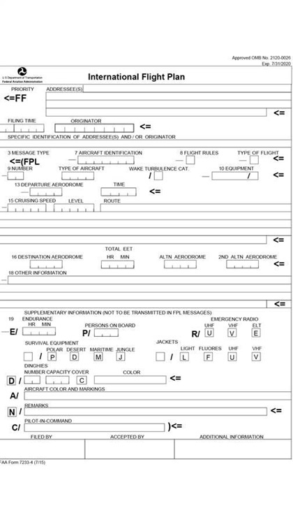
 The FAA flight plan form

