Surveillance from a Skyhawk
CFI eyes new business opportunity for flight schools
Augusta National Golf Club was off-limits to drones during The Masters in April, but flight instructor and AOPA member David Dobbins was in the air, with permission to patrol, broadcasting live video from a Cessna 172 Skyhawk using an imaging system of his own invention.

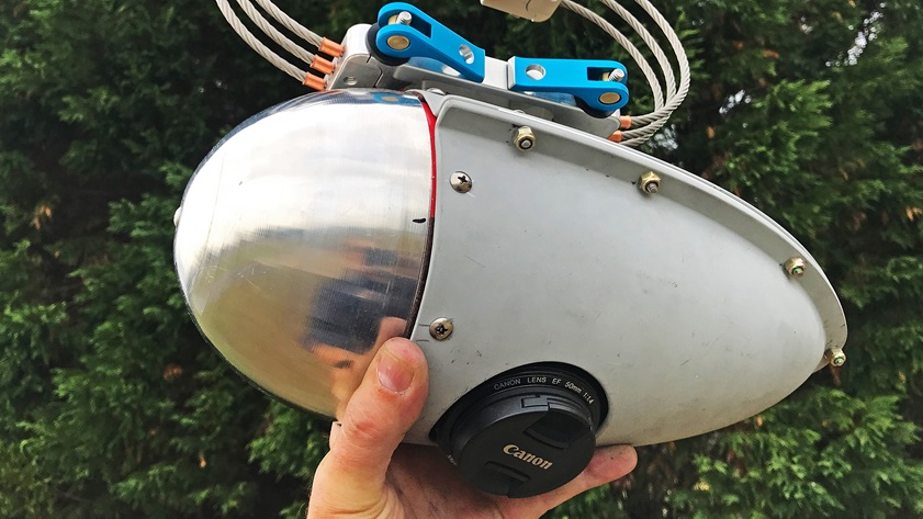
The sensor pod Dobbins crafted is a prototype that could one day be mass-produced and leased to aircraft operators across the country, giving flight schools and other commercial aviators a new revenue stream, and providing consumers of image data a convenient, on-demand end-run around unmanned aircraft flight restrictions that keep many drones grounded over populated areas.
“Other providers need to not feel threatened,” Dobbins said. “This pod and this project is not here to replace all of the data-collecting assets out there … from satellites to the single-quadcopter owner-operator. We want to be the go-to place for the data, that’s the message I need to get out.”
Dobbins logged about 20 hours over the tournament, flying at about 1,200 feet agl, safely above the 1,000-foot minimum altitude during the proof-of-concept mission. He noted there were still some rough edges to smooth out—video latency of about 30 seconds being one, and the lack of a gyro-stabilized gimbal to smooth out the bumps being another. He is working on a new design that will incorporate multiple imaging devices. The live video feed he broadcast online in April suffers from an image quality standpoint due to high winds, turbulence, and bandwidth limits, but nonetheless illustrates the potential, with a split-screen view that includes a live ForeFlight aircraft track alongside the video captured by a Canon 5D Digital SLR camera and beamed down to the ground through a cellular hotspot.
Dobbins said his work overseas flying unspecified military drones in unspecified locations inspired the creation of a concept, and also paid for the Cessna Skyhawk he teaches in out of Augusta Regional Airport at Bush Field. (“I worked multiple platforms in quite a few venues. Six different countries. That’s about all I can say,” he confided).
Flying those decidedly nonpublic missions overseas gave him insight on how the technology could be more efficiently used. It is very expensive to operate a high-tech camera system for just one customer, such as a military or other government entity, but Dobbins said a civilian setup where users around the country, or around the world, can sign up for video and still images captured by Cessnas flown with pods attached would change the economic equation dramatically.
Once he has a production model ready, he envisions leasing imaging pods to operators around the country, and matching that sensor package with an app that allows end users to monitor live images and even request a closer look at specific locations.
“It has to be fractionalized,” Dobbins said in a telephone interview. “Do you need to operate a Predator 14 hours a day? No. It may only be for minutes … you can cover a lot of ground at 100 miles per hour.”
The camera pod, affixed to the landing gear strut of the Skyhawk, is small enough that Dobbins was able to avoid having to secure supplemental type certification. The U.S. Army veteran (Dobbins served as a paratrooper with the 82nd Airborne, and later worked for the Secret Service) has “a good relationship with the FAA,” and was careful not to ruffle feathers when overflying competition during the Masters. He gave the relevant regulators a heads-up well in advance, he said.
“We were looked at all the way to Washington,” Dobbins said, noting there were “no complaints at all.”
There’s a limit to how much mass can be affixed to a Skyhawk strut, however. “Now if we’re talking about multi sensors, there’s a weight concern.”

He’s working on a white paper to spell out a case for flying up to 55 pounds of gear on an external mount, noting that the FAA allows drones to fly up to that weight, so why not have the “drone” attached to one of general aviation’s most reliable and proven aircraft? “To make that as painless [and] as frictionless as possible is our goal,” Dobbins said.
Dobbins has done his homework, and is aware of STCs that do much the same thing, including one that allows for a gimbal-mounted camera to be attached to the outside of a Cessna 172’s cargo door. He’s looking to make something more affordable, and suitable for mass production.
“We intend to lease those to providers,” Dobbins said. “That’s how we’re going to horizontally scale this project.”
Dobbins has already found customers for the data he can generate today using off-the-shelf cameras and transmitters. South Carolina-based Full Circle Aggregates told The Augusta Chronicle that hiring drone operators to image the firm’s five sand mines and landfills spread across four counties was more expensive than hiring Dobbins.
“I think there’s going to be a great synergy between the general aviation community and business owners like myself,” Full Circle Aggregates co-owner Ryan Williams told the local newspaper. “They’re already up there, so why not take a few pictures? They can make a little money and we can save a little money.”
Dobbins is ready, willing, and able to deliver images on demand for news outlets, public safety agencies, and other customers who need data, particularly over large areas or in controlled airspace where drone flight is either prohibited or cost prohibitive.
He is licking his lips at the thought of the next generation of mobile broadband. “When 5G rolls out, that’s a game-changer for us,” Dobbins said. “This is really just on the cusp of taking off. Live is where we thrive.”
Dobbins remains busy teaching students through his flight school, MVP Aviation (an acronym for “most valued pilots”), and he established Eureka Earth, a subsidiary of Civicus Media, to serve digital imaging customers. He’s eager to partner with other firms that offer remote sensing technologies, perhaps one that already has an app for that. Meanwhile, he’ll be happy to offer some dual instruction, or an orientation flight, or a sightseeing tour, perhaps doing a little filming on the same flight for another customer.
“I just enjoy the instructing, the instrument instructing,” Dobbins said. He also knows very well that flight schools need to scale up or develop independent revenue streams to thrive. One day, he said, “we’re going to be able to do that in 400 cities around the country.”