Technique: Charting your course
Sectionals contain a wealth of information
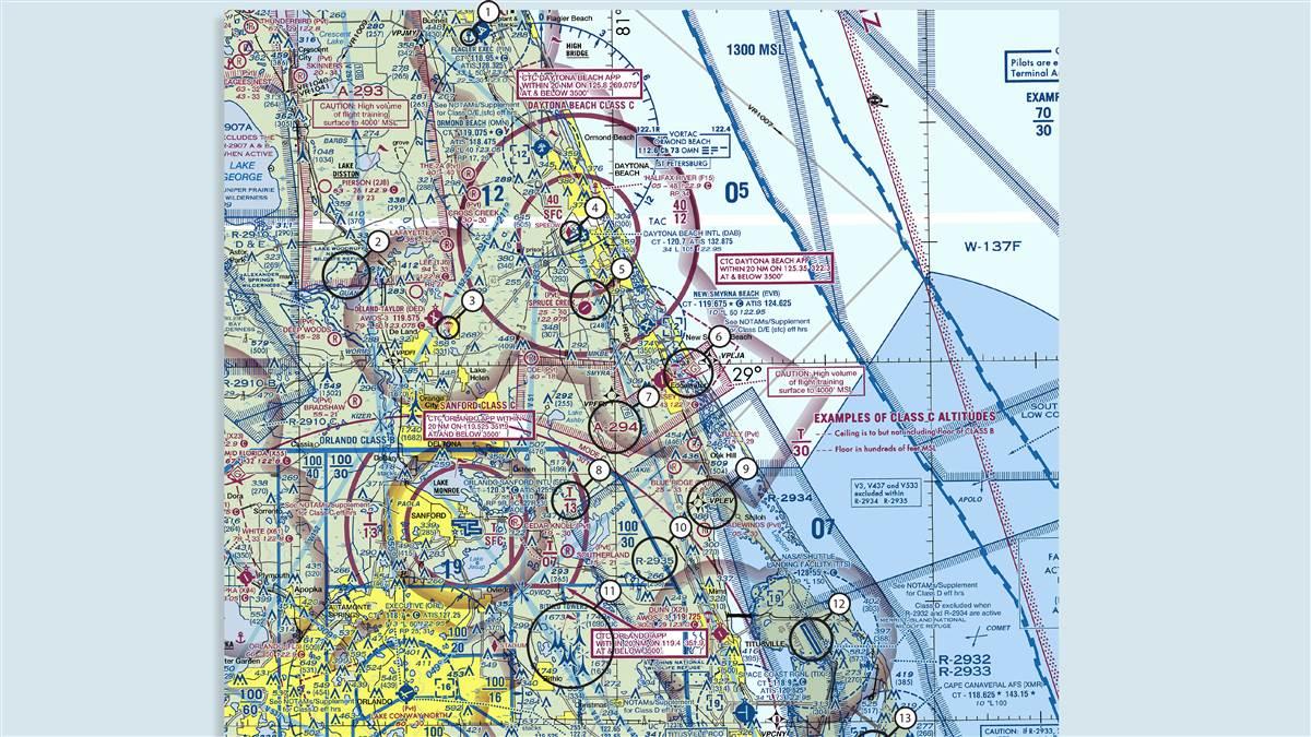
Whether you fly using digital aeronautical charts or their analog—as in, printed on folding paper—equivalent, charts contain a wealth of information important to your flight. There are other details that are simply interesting until understanding them becomes important for a flight. Here are a few interesting features from the Jacksonville Sectional Aeronautical Chart, along Florida’s Atlantic Coast from Flagler Beach south to Cocoa Beach.

While the airspace along this stretch of coastline looks intimidating at first glance, with proper planning it can be navigated without requiring any clearances or even talking to air traffic control. Want to know more? The FAA Aeronautical Chart User’s Guide contains far more information than you’ll find on a paper chart’s legend, and it can be read online or downloaded.
- Flagler Executive Airport offers a seaplane landing area on the field, using Waterway 18W/36W.
- Wildlife refuges such as Lake Woodruff National Wildlife Refuge—as well as national parks, primitive areas, and wilderness areas—are special conservation areas. Pilots are requested to avoid flight below 2,000 feet agl in these areas.
- Deland Municipal-Sidney H Taylor Field Airport has a parachute jumping area. If no frequency is specified, listen on the unicom frequency for jump information.
- The maroon diamond at Daytona Beach International Airport denotes a sporting event temporary flight restriction (TFR) site; check notams to make sure no TFR will affect your flight. In this case it marks Daytona International Speedway, located right beside the airport.
- The maroon flag indicates that Spruce Creek Airport, a private landing strip, is a VFR checkpoint. This is a good place to call air traffic control for permission into nearby controlled airspace.
- In addition to skydiving, Massey Ranch Airpark has glider operations.
- An alert area, such as A-294, informs nonparticipating pilots of airspace that may contain a high volume of pilot training or unusual aerial activity. Here, it’s pilot training—lots of it.
- “T” indicates that Orlando Sanford International Airport’s Class C airspace goes to but does not include the floor of the overlying Orlando Class B airspace—here, 3,000 feet msl.
- This five-letter fix, beginning with “VP,” is a VFR waypoint. These waypoints are established to help VFR pilots navigating with GPS, and should be accessible in up-to-date navigation databases. Use them as waypoints to plan a route and navigate around complicated airspace, but do not expect air traffic controllers to be familiar with them.
- R-2935 is part of a multi-tiered restricted area surrounding the Kennedy Space Center; it overlies multiple Class G and Class D airports and juts into the eastern boundary of Orlando’s Class B airspace.
- This group obstruction symbol indicates multiple obstacles, 1,000 feet or more above ground level, marked with high-intensity strobe lighting that may operate part-time or only when aircraft are nearby.
- Space shuttles no longer land at the NASA shuttle landing facility but the 15,001-foot-long runway is a great landmark.
- The magenta rocket symbol indicates that Cape Canaveral Air Force Station is a designated space launch activity area.

Mike Collins
Technical Editor
Mike Collins, AOPA technical editor and director of business development, died at age 59 on February 25, 2021. He was an integral part of the AOPA Media team for nearly 30 years, and held many key editorial roles at AOPA Pilot, Flight Training, and AOPA Online. He was a gifted writer, editor, photographer, audio storyteller, and videographer, and was an instrument-rated pilot and drone pilot.


