Weather: Clues in a cloud
Cumulus congestus often heralds thunderstorms

Cumulus congestus clouds like the one pictured here are also called towering cumulus clouds because they reach high into the sky. They often, but not always, grow into thunderstorms.
1. This part of the cloud has a hard-edged, cauliflower-like appearance that’s caused by fast updrafts, which are lifting supercooled water drops so fast they aren’t turning into ice crystals.
2. This smooth area is where the updrafts have slowed and supercooled water drops have turned into larger ice crystals, which don’t reflect as much light as numerous tiny water drops. Scientists call this “glaciation.” It’s a sign that the cloud is on the way to becoming a thunderstorm, if it hasn’t already done so.
Illustration by Kevin Hand
It’s Electric
Charged up
Storm’s turbulence helps create lightning
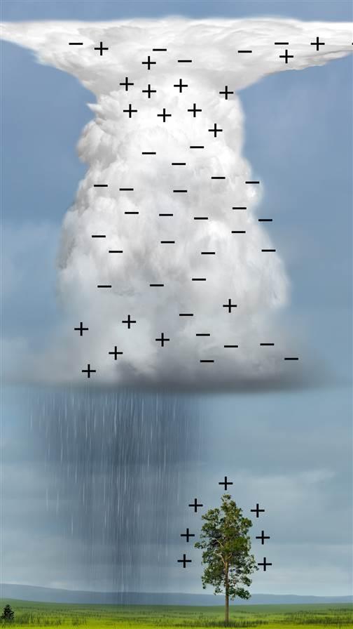 Scientists continue to work out the details of how cumulus congestus clouds and thunderstorms create the electric charges that cause lighting, but the leading hypothesis is that collisions among water drops, ice crystals, and the tiny slushy particles called graupel create positive electrical changes on the lighter particles, which rise to the cloud’s top—and negative charges on the heavier particles, which fall to the bottom of the cloud. This leads to lighting strikes between the negative charge in the bottom of the cloud to the area of positive charge at the surface, and things on the surface such as trees, buildings, and airplanes sitting on ramps. —JW
As the weather warms up, thunderstorms become more common across most of the United States, especially during the afternoon and evening. Each year roughly 100,000 thunderstorms hit the United States. About 10 percent of these reach severe levels, with winds of 58 mph or faster, or hail one inch or larger in diameter.
Even the weakest thunderstorm brings gusty winds, while stronger storms sometimes blow down trees. In addition to hail, a mature thunderstorm at the height of its power is a maelstrom of supercooled water that turns to ice when it hits your airplane, hailstones (chunks of ice that can be bigger than baseballs), large raindrops, and violent up- and downdrafts that could shake your airplane with severe and extreme turbulence.
During the cumulus cloud stage of a thunderstorm’s development, air is rising into the cloud, causing the cloud to grow higher. When rain begins falling, the falling rain drags air down, causing downdrafts.
When a strong downdraft—known as a downburst—hits the ground, it causes sudden shifts in wind strength and direction that may send flames roaring into fire-fighting crews. Downbursts also have killed pilots and passengers when they were caught near the ground by the sudden wind shift. Obviously, pilots also should be wary of towering cumulus clouds.
If a towering cumulus cloud does become a thunderstorm—many weaken and die without making it—this is considered the first of the thunderstorm’s three stages. Pilots should avoid towering cumulus clouds, because any one could grow into a thunderstorm while you’re in it. Even if it doesn’t, you’d still be in for a rough ride.
Thunderstorm advice for pilots. The FAA, meteorologists, and experienced pilots advise staying at least 10 miles from any thunderstorm and 20 miles away from a severe thunderstorm. A good way to avoid thunderstorms is to fly early in the day, before the ground has warmed up enough for rising air to begin forming cumulus clouds. If you plan to fly far from your home airport, you should make sure during your preflight weather briefing that thunderstorms are not expected near your route later in the day.
Forecasters have improved their ability to say when and where, in general, thunderstorms are likely to form; however, you should stay alert and keep up with the weather by checking in with flight service on 122.2 MHz.
If you see growing cumulus clouds ahead or the forecast changes to a possibility of thunderstorms, you should turn back or land and wait for the clear, smooth air that sometimes follows thunderstorms. —JW
Related Articles


