Weather: Correlating cloud types
Anticipate their effects on your flying


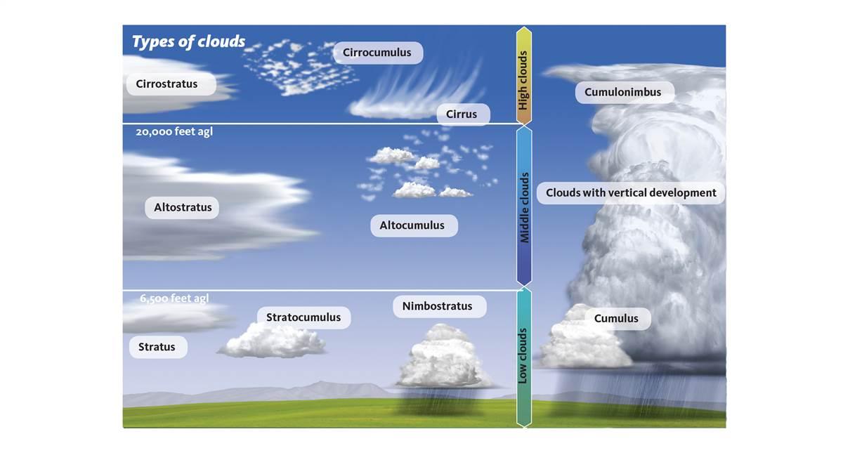
Cirrostratus clouds are generally flat clouds higher than 20,000 feet agl. A nimbostratus cloud also is generally flat, but close to the ground. In practical terms for pilots, if you’re flying under visual flight rules, cirrus clouds aren’t a concern; they’ll be high above you. Nimbostratus clouds, on the other hand, are less than 6,000 feet above the ground—often far below 6,000 feet. Since they are flat clouds that cover large parts of the sky, they can be a showstopper for VFR flights.
HOW CLOUDS ARE NAMED. The system for naming clouds (see p. 53) is essentially the system that Luke Howard, a London businessman and amateur scientist, developed and first presented in 1802. It categorizes clouds by their heights above the ground and whether they are generally flat (stratus) or lumpy and piled up (cumulus).
Historians say Howard’s system of naming clouds encouraged the development of meteorology as a science because it helped scientifically minded people realize that clouds aren’t random collections of water drops, but are parts of an organized system. When he presented his system to the public, Howard wrote, “Clouds are subject to certain distinct modifications, produced by the general causes that affect all the variations of the atmosphere; they are commonly seen as good visible indicators of the operation of these causes.”
In a similar way, understanding cloud names and associating them with what you see in the sky will help you to better picture the factors affecting your flight.
 A CLOSER LOOK AT CLOUDS. Stratus clouds tend to form when a large mass of air rises at more or less the same speed to cover a large part of the sky—maybe all of the sky you can see. They are generally flat.
Cumulus clouds form when bubbles of air are rising while air is sinking nearby. While the bottoms of cumulus clouds typically are flat, the tops can rise like castles in the sky in some places—and hardly at all in others. You’ll usually see breaks between the clouds.
Clouds higher than 20,000 feet are called cirrus clouds or have names beginning with cirro. Since they’re so high, they are made mostly of ice crystals, although scientists have found supercooled water drops (water still liquid although colder than 32 degrees Fahrenheit). Cirrus clouds have wisps of snow falling from them (often called “mares’ tails”) that quickly evaporate. More or less solid sheets of these high clouds are called cirrostratus clouds, while those with lumps are cirrocumulus clouds.
Although these clouds don’t directly affect most general aviation pilots, they often offer clues to the weather in the next two or three days; they could be the leading edge of the clouds created by an approaching storm.
KEEP AN EYE ON MIDDLE-LEVEL CLOUDS. Clouds between roughly 6,500 feet above the ground up to 20,000 feet agl have names beginning with alto, such as altostratus and altocumulus. When you see middle-level clouds begin to replace high-level clouds, you should suspect that lower clouds and precipitation are on the way.
Clouds below 6,000 feet don’t have a prefix indicating their height. If they are lumpy, they are cumulus clouds of various kinds. If they are flat, they are stratus clouds or have strato or stratus in their name, such as nimbostratus. Nimbo means rain or snow is falling from the clouds.
To tell stratocumulus, altocumulus, and cirrocumulus clouds apart, extend your arm pointing at the lumps in the clouds. If your little finger covers a lump, the clouds are cirrocumulus. If your thumb roughly covers one of the lumps, the clouds are altocumulus. If your fist is needed to cover a lump, then you’re looking at stratocumulus clouds.
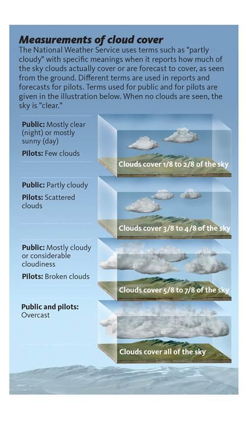
In addition to knowing the different types of clouds and how they could affect a flight, pilots also need to know what meteorologists mean when they refer to scattered clouds or overcast (see p. 53).
RISING AIR HOLDS CLOUDS UP. Clouds are made of tiny drops of water or small ice crystals that are always falling. For a cloud to stay together and in the sky, air must be rising into it at least as fast as the water drops or ice crystals are falling at what’s known as their terminal velocity, which depends on their size and weight.
Air cools as it rises; when it cools to the dew point, the water vapor in the air begins condensing into tiny drops of water or sublimating into tiny ice crystals. These create the clouds we see. In a strong thunderstorm, air can be rising at 100 mph. In an ordinary stratus cloud it will be rising as slowly as a few inches an hour. Air does not have to be rising straight up to form clouds; it can be ascending at an angle, such as where warm air ahead of a surface warm front is sliding up over colder air next to the ground.
These typical terminal velocities show how fast the air has to be rising for clouds, rain drops of certain sizes, or hail to form:
Typical cloud drop: 0.02 mph
Small rain drop: 4.5 mph
Large rain drop: 20 mph
Large hailstone: 100 mph
Growing cumulus clouds have generally flat bottoms showing where the rising air has cooled enough for water vapor in the air to begin condensing into cloud drops, or—if the air becomes cold enough—depositing directly into ice crystals.
CLOUD COLORS. The water drops and ice crystals that make up clouds are large enough to scatter all wavelengths of sunlight. That is why the tops of clouds and their sides facing the sun are white—except near sunrise and sunset, when light has traveled so far through the atmosphere that all of the other colors have been scattered away, leaving only red and orange to paint the clouds.
If a cloud is thin enough, its bottom could also be white. At least half the sunlight hitting a cloud less than 3,000-feet thick makes it though the cloud, which is why the bottoms of many clouds are gray. Since little sunlight passes through clouds more than 3,000 feet deep, their bottoms are dark.
Illustrations from The AMS Weather Book, used by permission of the American Meteorological Society.
Ceilometers measure cloud height by sending up laser pulses and measuring the time needed for the infrared light to be reflected back.


