Hard to believe, but the ubiquitous workhorse IFR GPS receiver, the Garmin 430, was introduced 17 years ago in 1997. With more than 100,000 Garmin 430s and 530s shipped, it still has the largest installed base of any IFR-capable GPS. Yet despite its longevity, pilots are still asking basic questions about it, such as “When should I Load versus Activate?” or “When do I switch to VLOC on an ILS or VOR approach?”
Lest you think any of these questions are trivial, the former question became a full page in my Max Trescott’s GPS and WAAS Instrument Flying Handbook. As for the latter question, there’s finally an official FAA answer and surprisingly, it’s different depending upon whether you’re flying an ILS or a VOR approach.
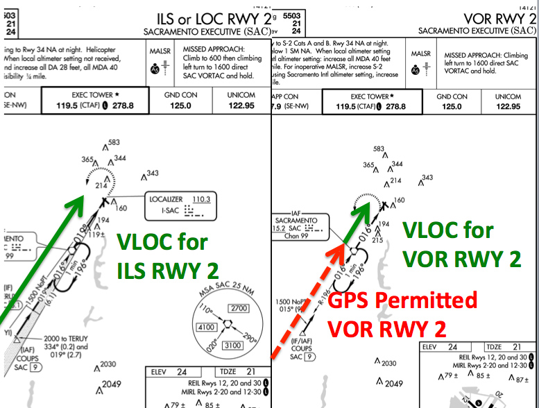
For a lot of people flying mostly ILSs into the same few airports, the answer may seem simple. They might respond “Well the CDI just switches automatically to VLOC as I’m about to intercept the final approach course.” That is true some of the time, though only for ILS approaches and only if you’ve turned on the ILS CDI Autocapture in the Garmin 430 or 530’s AUX group.
But the automatic switching on an ILS only occurs if you intercept the final approach course between 2 to 15 miles outside the Final Approach Fix (FAF). That’s not a problem for most ILSs, but for a really long one with a large descent of perhaps 5,000 feet or more (e.g. the ILS 31 at Salinas, Calif. or the ILS 32R at Moffett Field, Calif.) the CDI won’t switch automatically as you join the final approach course. In these cases, you’ll need to manually switch it. Of course, you’ll always need to manually switch it for any non-ILS approach that uses a Nav radio, such as Localizer, VOR, VOR/DME, LDA, SDF, and Localizer back course approaches.
How Late Can You Switch?
But when are you required to switch to the Nav radio for primary guidance? Imagine you’re on a checkride and you forget to switch the CDI from GPS to the Nav radio. How far can you proceed along the approach before you fail the checkride because you didn’t switch the CDI to the Nav radio?
The story I heard years ago—but never confirmed so I don’t know if it’s true—was that Garmin and Cessna gave differing guidance on this point, because they were located in different FSDOs and got different guidance from their local FAA regional offices. One said you had to switch the CDI or HSI to the NAV radio as soon as you turned onto the final approach course. The other said that you didn’t have to make the switch until you reached the FAF. Which is correct? Like most things in life, it depends!
The FAA reference for this is AC 90-108, dated March 3, 2011. For an ILS, localizer, LDA, or localizer back course, Section 8. c. says that an RNAV System (e.g. a GPS) cannot be used for “Lateral navigation on LOC-based courses (including LOC Back-course guidance) without reference to raw LOC data.” This means that as soon as you turn onto a localizer or ILS, you need to display course guidance from the Nav radio. On the Garmin 430/530, that means as soon as you turn onto the localizer, you must push the CDI button so VLOC is displayed.
But oddly for a VOR approach, the answer is different. Section 8. b. says that an RNAV System (e.g. a GPS) cannot be used as a “Substitution for the NAVAID (for example, a VOR or NDB) providing lateral guidance for the final approach segment.” The final approach segment always starts at the FAF, which is marked with a Maltese cross. So on a VOR approach, you can fly all the way to the FAF before you need to switch the CDI or HSI to the Nav radio. Fly past the FAF using just the GPS (as I saw a client do a few days ago) and you’ve busted your checkride, and the regulations if you were to do it for real on an IFR flight plan.
How Early Should You Switch?
Waiting until the last possible time to switch the CDI or HSI to the Nav radio rarely makes sense. My guidance to clients is when the controller first begins issuing vectors—meaning you’re no longer using the GPS for primary guidance—switch the CDI or HSI to the Nav radio (unless of course you’re flying a GPS approach). That gives you time to verify that the course is set correctly before you join the approach course.
I saw a great example of why that’s important while teaching last weekend at a Cirrus Pilot Proficiency Program (CPPP) in Concord, Calif. One of the attendees I flew with didn’t switch the HSI to the Nav radio until the moment he turned onto the final approach course for the LDA RWY 19R at KCCR. At that time, I noticed that the HSI’s course pointer was incorrectly set for 191 degrees rather than the 181 degrees required for the approach, but didn’t say anything because I wanted to see if and when he’d catch the error. Had he made the switch earlier, he would have had more time to review his setup and possibly catch this error.
The needle remained centered, though it was pointed 10 degrees away from our heading. As we crossed the FAF, he asked “Now do I turn ten degrees to follow the pink line to the airport?” I was stunned that he came up with that as a possibility, since localizer signals are always beamed out in a straight line with no turns. Clearly he knew there was a problem in the conflicting information he was seeing, but he never considered the possibility that the course was set incorrectly.
The mantra I teach clients is to review “MORSE, Source, Course” as part of their setup for an instrument approach. There’s no need to check the MORSE code ID or to set the CDI Course when flying a GPS approach, but they’re absolutely essential to check and set anytime you’re using the Nav radio.
Why Does the FAA Allow the Switch to Occur Later for a VOR
So why must you switch to the Nav radio as soon as you turn onto an ILS or localizer, but can wait until the FAF to make the switch when flying a VOR approach? Consider an instrument approach with a VOR at the FAF. You might guess that when on the approach outside the VOR, a GPS signal keeps you closer to the centerline than a VOR signal, but that’s only true when you’re more than 6 NM from the VOR. At that point, the GPS is in Terminal mode and full scale CDI deflection is ±1 NM, which matches the ±10° full-scale deflection for a VOR signal at that distance.
Six miles is probably close to the average length of an intermediate segment, so while I have trouble saying these words [choke], the VOR would actually be more precise for navigating the last six miles to the FAF. Yes, a VOR signal scallops around a lot, but usually not much when you’re that close to a VOR.
The real benefit of GPS accuracy when flying a VOR approach occurs when you’re flying the initial segment, almost all of which would be more than 6 NM from a VOR at the FAF. Not only would GPS keep you closer to the centerline, but more scalloping occurs on a VOR signal at that distance.
It’s a little tougher to do the same analysis on an ILS or localizer approach, since the beamwidth of the localizer varies between about 3 to 6°,depending upon the particular installation. Suffice it to say that any approach with a localizer will have a narrower beamwidth, keeping you closer to the centerline, than a VOR approach when at the same distance from the antenna site. Just remember that localizers are more precise, so the FAA wants you to start using the Nav radio as soon as you turn onto one. But VORs are less precise, so you don’t have to switch to the Nav radio until you reach the FAF.
Postscript
After reading this post, a friend emailed suggesting I’d misinterpreted AC 90-108 and came to the wrong conclusion about needing to switch to localizer data as soon as you turn onto the final approach course. I sought clarification from AFS-470 at FAA HQ and they quickly responded confirming that pilots MUST use raw localizer data for primary guidance along the entire localizer. They raised an additional point that a reader also mentioned in the Comments section. Both pointed out that a pilot can always monitor RNAV (GPS) data as they fly along a localizer. However they cannot use it for primary navigation. The pilot must have raw LOC data displayed on their primary instrumentation and must use that LOC/VOR data for primary navigation. My thanks to everyone who contributed to this discussion! — Max Trescott
Related Articles


