The mountains are calling
Flying the majestic Yellowstone region

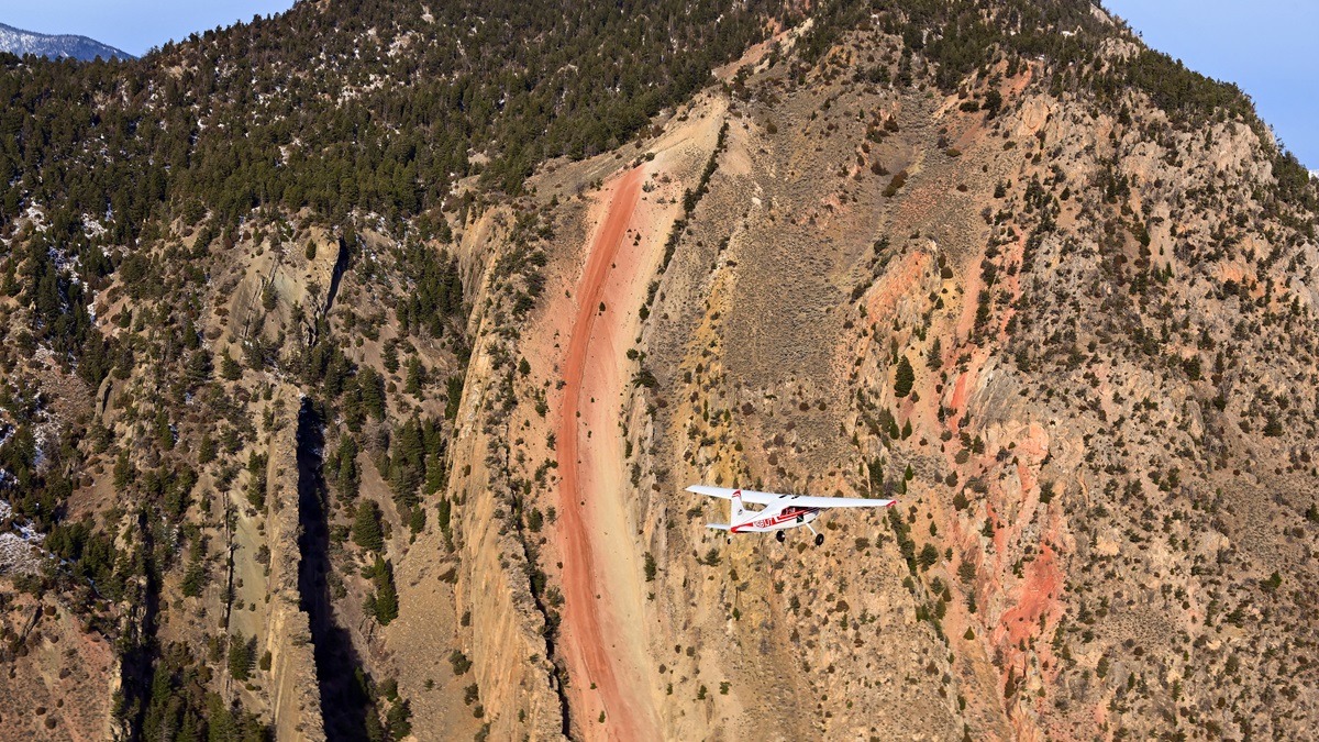
Traversing the western slope of the Rocky Mountains near the majestic Grand Teton, the American Champion Citabria I was flying kept gaining altitude despite a nose-down pitch attitude and idle power.
From 12,000 feet, it rose like an express elevator to 13,000 feet, then 14,000 even though I was pushing the nose down and the needle on the airspeed indicator was flirting with the yellow arc. Finally, near Driggs, Idaho, the powerful updrafts relented, the airplane’s agreeable temperament returned, and a normal descent and landing followed.
“These conditions are pretty much normal for a summer afternoon in the mountains,” said John McBean, head of Kitfox Aircraft in Homedale, Idaho, and a CFI who has flown in this region for decades. “The wind hits the western slope of the mountains and it’s got nowhere to go but up. Throw in some heat from the afternoon sun and you’ve got the recipe for extremely powerful updrafts.”
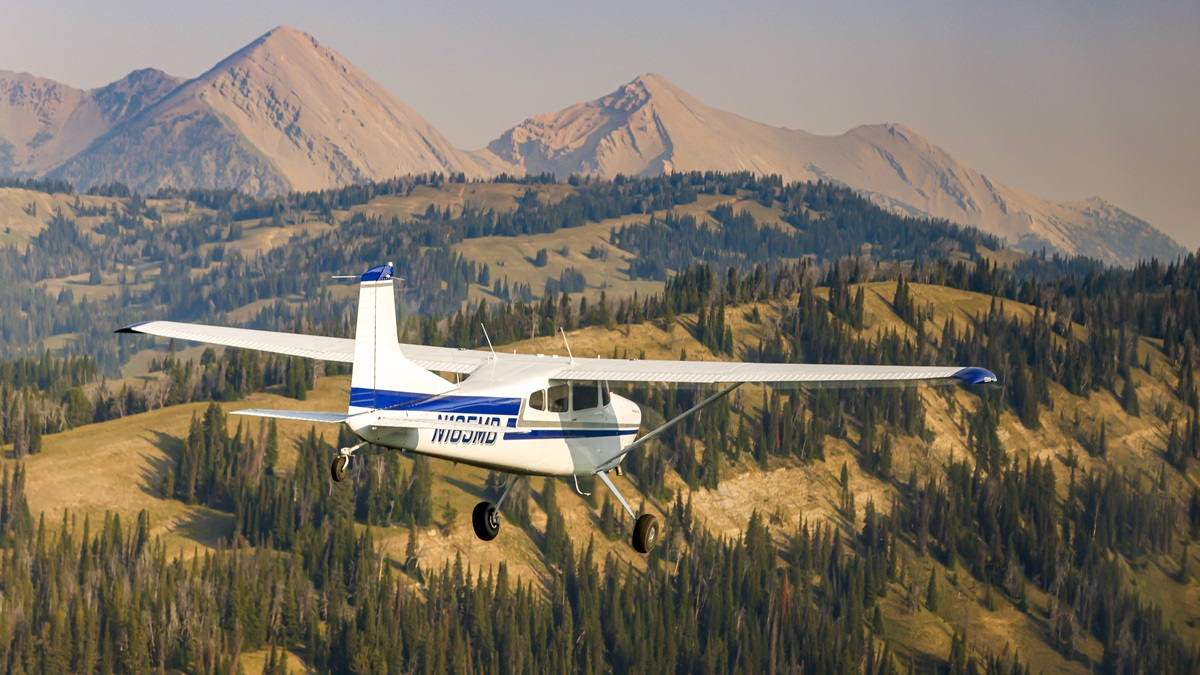
The Yellowstone region of the Mountain West is an awe-inspiring and rewarding place for general aviation pilots to fly—and not just those with specialized short-takeoff-and-landing airplanes seeking out extreme, off-grid adventures. Cities and towns throughout this area have hard-surface runways of adequate length for the full spectrum of general aviation aircraft.
The winter and summer peak seasons for outdoor recreation draw the most visitors—and the seasons themselves are vivid studies in contrast. Winter brings extreme low temperatures, powerful jet stream winds at high altitude, and crystal-clear days with visibility that can top 150 miles. Summers tend to be cool and comfortable at the surface, but pilots must contend with high density altitudes, wildfire smoke, and thunderstorms that can produce hail and lightning.
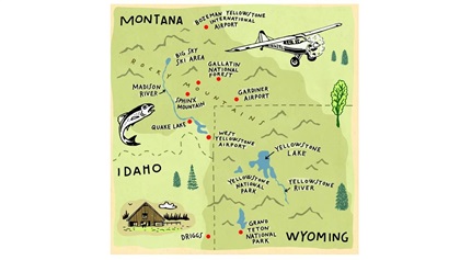
The Mountain West


Flying tips for the mountain west
 During summer, fly in the mornings when surface winds are calm, and plan to be on the ground by 11 a.m. to avoid swirling surface winds and turbulence.
Density altitudes can be extreme in summer, and they can dramatically degrade aircraft performance.
Smoke from forest fires, even distant ones, can radically reduce visibility—even when VFR conditions are reported. Check NOAA’s fire and smoke map (fire.airnow.gov) for the latest conditions.
Fly on the windward (upwind) side of mountain ranges and avoid the lee (downwind) side where rotors and downdrafts are likely to form.
Carry survival equipment to ensure warmth, hydration, and a personal locator beacon and/or satellite messenger.
Beware the possibility of icy clouds, even in summer.
Leave a detailed flight plan or your intended route of flight with a friend.
Be cautious about flying when winds at the mountain peaks are 25 knots or greater due to turbulence.
Spring and fall, known here as the “shoulder” seasons, are some of the best for flying with snow-capped peaks and cool temperatures—but they also usher in periods of high winds, turbulence, and localized valley fog. The vastness of this “big sky” region belies the complex series of tiny microclimates that comprise the Mountain West. It’s not unusual for dense fog to take hold in some valleys, and winds at high altitude are sometimes at odds with the strength and direction of wind on the surface. Temperatures and dew points are often close together at night and early mornings, and small changes in elevation are enough to bring them together.
“The Bozeman valley is less than 100 miles from West Yellowstone Airport,” said John McKenna, a founder of the Recreational Aviation Foundation who grew up in Montana and learned to fly here. “But it’s not unusual for the weather to be totally different. We’re accustomed to seeing 40- or 50-degree temperature swings in a day, so pilots have got to be aware of the changing conditions and stay flexible.”
Over Yellowstone
This ferry flight in a two-seat Aviat Husky is a relatively short one by Western standards—just 185 nautical miles as the crow flies—but it’s a sensory feast because of the splendor of the surroundings. From Aviat’s factory in Afton, Wyoming, a valley with snowcapped mountains to both the east and west, I fly north to Jackson Hole and parallel the Tetons with the iconic, 13,775-foot summit on my left side.
The morning sun paints the craggy and nearly vertical rock faces in sharp relief, and mostly still air allows me to fly level at 11,500 feet—about 2,000 feet below the jagged summit—yet close enough to see dirt and rocks embedded in the crusty snow. Jackson Lake is just ahead, and the mirror-smooth surface of the blue-water lake reflects snowy peaks and stratiform clouds beside and above me.
Visibility on this autumn morning is more than 100 miles, and I continue northeast toward West Yellowstone Airport (WYS) which sits on a high plateau. The nontowered field is almost directly along my route to Bozeman, Montana.
West Yellowstone Airport is just outside the national park boundary and listening to the common traffic advisory frequency reveals a mix of regional airline, corporate jet, firefighting, and general aviation traffic. The single runway isn’t terribly busy, but airplanes ranging from a Super Cub to a Global Express take off and land during the 20 minutes or so that I’m tuned in. I descend slightly to 10,500 feet to get a better view of the national park, and that puts me about 2,000 feet above the ground—the recommended minimum for the charted wildlife area over Yellowstone and surrounding national forests.
Groups of what looks like dozens of campfires dot the landscape ahead, but the plumes aren’t smoke. They’re steam from the countless geysers for which Yellowstone is renowned. On this cool and still morning, the distinctive clouds of vapor hold together and fill low-lying areas. There’s a tremendous amount of volcanic activity here, and even though the super volcano underlying Yellowstone has been dormant for tens of thousands of years, these geysers are visible signs of ceaseless geothermal action.
Yellowstone and beyond


Quake Lake (officially Earthquake Lake), on the Madison River about 25 miles northwest of the park, was created in 1959 when a powerful earthquake (7.5 on the Richter scale) caused a massive landslide that reshaped the river.
Several pathways through the mountains lead to Bozeman, and I follow the easternmost, which keeps me over Yellowstone the longest. I pass along the western edge of Yellowstone Lake, a sprawling piece of water fed by the Yellowstone River, then turn north to follow the river’s path.
Whitewater surges through the Grand Canyon of the Yellowstone and Yellowstone Falls just ahead. The water level isn’t particularly high, so I imagine what it must be like in springtime when the mountain snow is melting.
Looking for wildlife, I see a herd of about 20 elk and a few deer on the ridges atop the canyon, but my spotting skills are weak. I once flew in this region with an expert hunter and he called out mountain goats, moose, and other game that I failed to find at all. Later, I overfly a small herd of bison that seem to pay no attention to the Husky overhead.
Yellowstone is larger than the Eastern states of Delaware or Rhode Island, and about one-third of this massive reserve burned during a raging 1988 fire. The remnants of hundreds of charred tree trunks and other signs are still visible, but less obvious with each passing year. Recent summers have been smoky and hazy for weeks at a time, but the source of that smoke has generally been distant fires in other Western states.
I keep following the river to the north entrance of the park at Gardiner, Montana, where the elevation drops to 5,300 feet. The scenic, nontowered airport at Gardiner (29S) is quiet this morning, and I pass just east of Devil’s Slide, a towering rock formation with a nearly vertical line of orange-colored sandstone that resembles a Slip ’N Slide of epic proportions. I descend to 8,500 feet, and the massive peaks in the Gallatin National Forest tower above me. Farther west, the granite monoliths Sphinx Mountain and Lone Peak rise spectacularly from the Madison Range. Emigrant Peak to my right tops out at more than 11,000 feet in the imposing Absaroka-Beartooth Wilderness which stretches out of sight to the east.
Without a horizon, I glance frequently at the airplane’s attitude indicator to maintain level flight among this spectacular but dizzying terrain. The aviation charts, and the colorful terrain display on the Husky’s moving-map screen, let me know I needn’t climb to reach my destination, though. Nearing the town of Livingston, Montana, I turn left and cross the Bozeman Pass. My destination at Bozeman Yellowstone International Airport is clearly visible a little more than 20 miles ahead.
I’m out of the wilderness now, and Interstate 90 leads almost directly to the airport. A gigantic M carved into a mountainside with slabs of limestone by the Montana State University class of 1918 makes the location unmistakable.
Light west winds, and the Husky’s soft tundra tires, favor landing on the turf Runway 29G. The G stands for grass, and even though the busy airport served by multiple airlines is as active as ever, the tower controller kindly clears me to land on the smooth, 80-foot-wide, green surface.
It’s an odd juxtaposition as I come to a stop in the verdant grass, then follow a Boeing 757 and a 737 to the ramp. The jets head to the passenger terminal, and I seek out the Recreational Aviation Foundation’s pilot shelter among a bevy of metal hangars. The pilot shelter has tiedowns, a camping area, showers, and even a gas grill.
My head is still buzzing from a flight that felt at times more like an Imax movie.
Even though this trip is over, I’m already hatching plans on how and when to return. These mountains have an irresistible and lasting pull.
Natural wonders abound
Backcountry survival vest
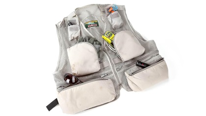 When packing survival gear, think of an adage from backcountry pilots: “Survival gear is only what’s on your body. Anything else is camping gear.” In the tumult following a mishap, items inside an airplane may be thrown from the airplane, or get destroyed in the crash or a follow-on fire. There is not always time to re-enter the airplane and look for needed gear. Keep essential survival items on you in a survival vest.
Cheap fishing vests are ideal for this purpose, especially vests designed for fly-fishing as they tend to have a lot of pockets, loops and, Velcro patches. Go to a local big box retailer and find a cheap vest that fits comfortably.
Think in terms of four Rs: Repair, Replenish, Refuge, Rescue. Limit your vest to essential, helpful items to keep it light weight and not too bulky to fly in.
Repair: Essential medical items to repair your physical condition.
- Burn gel.
- Gauze pad and adhesive bandages.
- Tylenol or Advil.
Replenish: Items to help you replenish nourishment with liquids and sustenance.
- A water filtering device such as those made by LifeStraw is lightweight and compact.
- Zip-lock bags to hold water.
- Energy or food bars.
- Fire starters and/or kindling sticks.
Refuge: Items to help you obtain refuge from the elements.
- Small tube of sunscreen.
- Small tube of insect repellant.
- Compact, high-visibility space blanket.
- Knife and/or multi-tool.
- Flashlight.
Rescue: Items to help you connect with rescue resources.
- Personal locator beacon or satellite communication device.
- Whistle.
- Signaling mirror.
- Parachute cord bracelet.
Saddle up
Nine Quarter Circle Ranch is a fly-in attraction
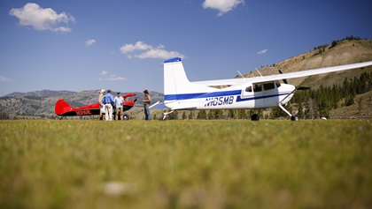 Nestled along a creek in the mountains south of Bozeman and northwest of Yellowstone lies the Nine Quarter Circle Ranch (1MT0). The seasonal, family-owned dude ranch has been in continuous operation by the Kelsey family for decades and is currently run and operated by Kameron and Sally Kelsey.
Kameron is a pilot and aspires to have his own airplane to fly in and out of the ranch. Their stunning 4,000-by-100-foot grass airfield opened in 1962 and flying in is a treat. While the strip is fairly long for the backcountry, the 6,974-foot elevation makes density altitude a factor even in the morning. The surface is mostly smooth and well packed—it serves as a pasture for the horses on an average day. If you fly in, call ahead so that the horses can be cleared from the runway. But be aware that the oldest, most stubborn horse (who has now gone deaf) may be reluctant to move for a mere visitor.
Instead of traditional hotel rooms, visitors stay in cozy log cabins. The ranch requires a minimum stay of a week, but there’s more than enough to do for those truly looking to relax and enjoy a ranch experience. There are guided and solo options for fly fishing, where even an absolute beginner may find luck. Or you can wander the property and take short local hikes. In the evenings, enjoy happy hour with the other guests, and take a ride in the Kelsey’s vintage Yellowstone tour bus. Weather and forest service permitting, enjoy a firepit as the sun sets, and bring your dancing shoes for the square dance in the barn at the end of the week, complete with a caller and music from well-loved vinyl. All meals are included, and the food is delicious. The family-style feel of the ranch makes it nearly impossible to leave without making friends, and regulars will often plan future vacations together to ensure they’re at the ranch the same week year after year.
Other than flying in, the unique highlight of the Nine Quarter Circle Ranch is its horses. The Kelseys and their wranglers breed, raise, and train their own Appaloosas. From daily trail rides to overnight pack trips, the ranch has something for every skill level (including rides just for kids). Guests are paired with a horse at the beginning of the week and ride with that one for their entire stay (barring any issues or horse/rider personality conflicts). On trail rides, traverse fields of Montana wildflowers with an experienced guide, look out onto Hollywood-ready peaks and valleys, and keep your eyes peeled for wildlife.
If you prefer a quiet day, have a cup of coffee and watch the light change over the airfield, relax with a good book, turn off your phone (there’s no service anyway but there is limited Wi-Fi), and time travel back to the golden age of the ranching West.
It is a curated yet authentic experience. If you’ve ever wanted to be a cowboy for a day, and you have the backcountry proficiency, fly in to the Nine Quarter Circle Ranch. —Alicia Herron

Related Articles


