It’s a fine fall afternoon: 10 miles visibility, a light south wind, high clouds. It's almost 3 p.m. Eastern Standard Time, and the station, in northern New England, is reporting barometric pressure of 30.27 inches hg, and a comfortable nine-degree (Celsius) temperature-dew point spread.
That's a serene weather picture. But if a pilot made the mistake of launching for a prolonged VFR flight based only on this information, a rude surprise would await, because conditions will soon deteriorate.
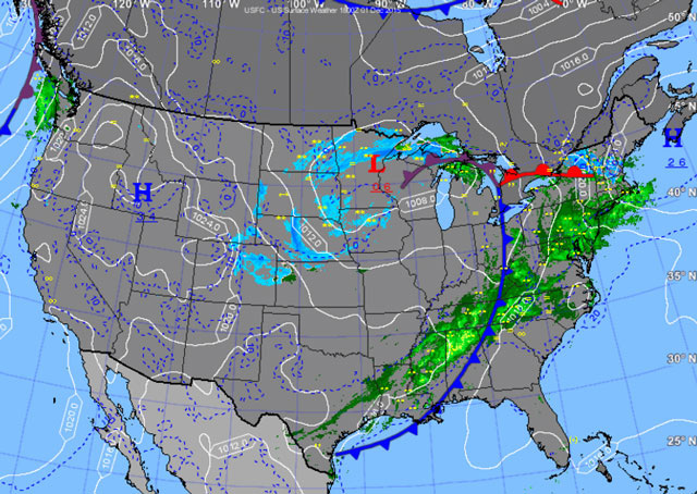
A more thorough weather briefing, commenced with a check of the current surface analysis chart, would raise the alarm. That chart depicts high pressure east of New England and a low pressure area west of the Great Lakes, with a warm front extending east, a cold front curving south, and in between, the extensive zone of bad weather typical of such systems.
Even a careful look at the station METAR summarized above would raise skepticism in a weather-wise pilot, because the southerly wind and three cloud levels, reported as “FEW120 SCT180 BKN250,” suggest that the weather is in a state of transition.
Next the pilot might check the station’s terminal aerodrome forecast. It calls for conditions to deteriorate to marginal VFR with light rain and low clouds in multiple layers after 03 Zulu, with instrument meteorological conditions three hours later: "FM020300 VRB03KT 3SM -RA SCT015 OVC025 FM020600 VRB03KT 2SM -RA OVC015 FM021300 VRB03KT P6SM OVC003." (Which forecast element after 06Z would rule out VFR flight?)
At an airport 100 miles to the southwest, the warm front is already knocking at the door. There, the visibility and barometric pressure are similar, but already light rain is falling, the multiple broken cloud decks are much lower, and there is a 9,000-foot overcast. By 11 p.m., instrument conditions will prevail there, according to this TAF excerpt: “FM020400 VRB02KT 2SM -DZ BR OVC005.”
None of this would come as a surprise to a wary pilot.
“Generally, prior to the passage of a warm front, cirriform or stratiform clouds, along with fog, can be expected to form along the frontal boundary,” notes the discussion of warm fronts in the Pilot’s Handbook of Aeronautical Knowledge. (See page 11-19.) “Light to moderate precipitation is probable, usually in the form of rain, sleet, snow, or drizzle,” it adds, describing conditions that match well with both stations’ near-term forecasts.


