Wilderness beckons in Big Bend, Texas
Take a giant step
Big Bend


That’s when we knew: Big Bend, Texas, had been worth the trip.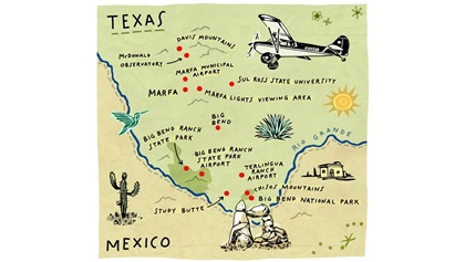
Big Bend refers to the westernmost segment that juts out like a hitchhiker’s thumb from the rest of the state. It’s an arid, rugged swath that reaches down to Mexico and is bordered by the Rio Grande, and its mountain ranges are as imposing and beautiful as any that can be found in New Mexico or Colorado. Here is where you’ll find Big Bend National Park and Big Bend Ranch State Park, whose combined footprint presents more than a million acres to explore by airplane, car, or boat.
Getting here isn’t easy. Senior Photographer David Tulis and I flew commercially to Midland, Texas, about as close as we could get, and without access to a small aircraft in Midland we still had a three-hour drive from there. Viewing the sandy terrain punctuated by the occasional oil derrick, we began to worry. Would pilots want to make the effort to come here?
After we had put Midland in the rear-view mirror and ventured deeper south and west, our concerns dried up. The grubby, featureless terrain disappeared, to be replaced with a landscape that sharpened and darkened as hills and then mountains with distinct features presented themselves.
sights and sightings


Two climates
When you’ve lived your entire life in a state the size of Maryland, it is startling to come to Texas, where “big” just doesn’t seem like an adequate descriptor. Presidio County, home of the Big Bend region, is 3,800 square miles—and it isn’t even the largest county in Texas. It’s not uncommon to experience different climates within the county. Marfa, elevation 4,790 feet, was 62 degrees Fahrenheit during our December visit. The town of Presidio—56 miles southwest—sits at 2,610 feet and was enjoying 67 degrees, warm enough to go without a jacket on the ground. Those mild temperatures make Big Bend a popular destination in winter months. In summer, however, outside temperatures can soar to 115 to 120 degrees F. Density altitude is a factor, and so visiting pilots need to be well-versed on the effects of “hot and high” on aircraft performance.
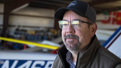
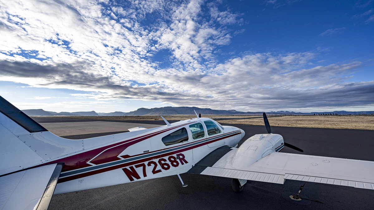
Our genial tour guide, Mark Morrison, showed us the incredible vistas from the 1966 Cessna 182 he uses for business travel for his construction company. He also has a Cessna 140 that he flies on shorter hops—shorter being a relative term here in Texas.
“A 35-mile car trip can take three hours,” Morrison said. “There are no direct roads here.”
But with Morrison’s capable 182, we were able to map out incredible vistas for visiting pilots:
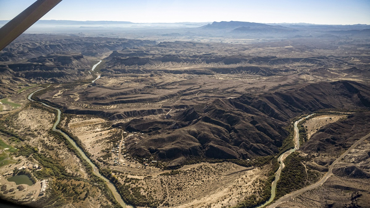
Santa Elena Canyon: The meandering 13-mile canyon with 1,500-foot vertical cliffs of limestone is a popular destination for overnight hikers and river rafters. A shorter hiking trail can be completed in one hour.
Chisos Mountains: Forty square miles of mountains created by volcanic activity 35 million years ago are waiting for you within Big Bend National Park.
University of Texas at Austin McDonald Observatory: This imposing silver building hosts a telescope that can observe almost all objects in the northern sky. Come back in the evening for a “star party,” where you can view those celestial objects through high-powered telescopes. Reservations are required.
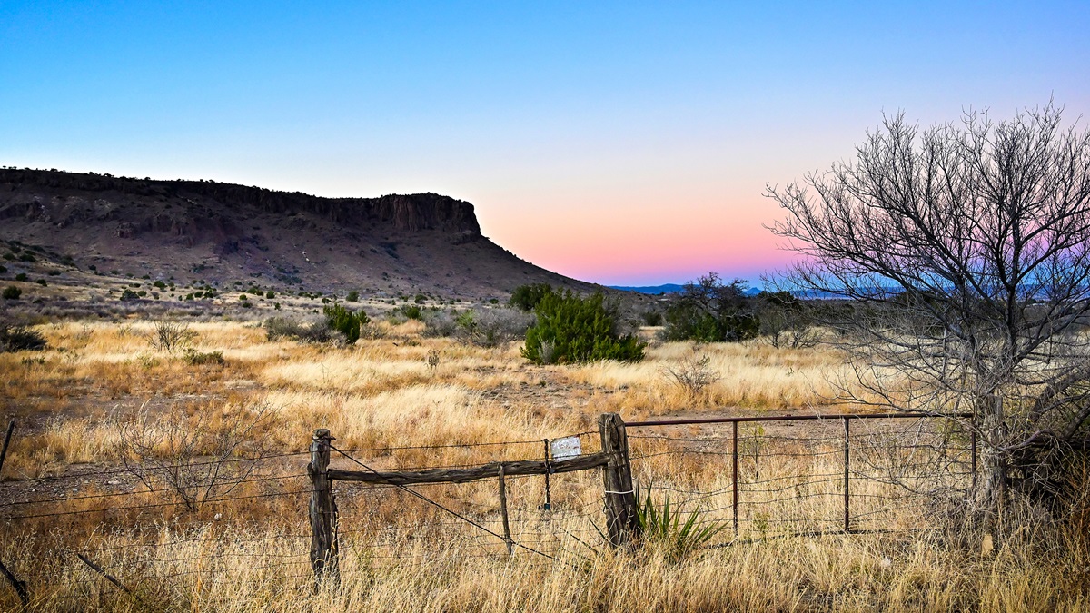
Capote Peak: Not named for the twentieth-century author, but rather from the Spanish word for “cloak” or “cape.” Morrison said it’s because the peak’s swirly top resembles a cape, but the name may also refer to fog or mist that sometimes surrounds the peak.
Closed Marfa Army Airfield: Opened in 1942 and placed on standby status in 1945, this once-bustling airfield had six paved runways, a control tower, hangars, plus a hospital, barracks, chapel, and theater. All that remains is the faint outline of those runways and taxiways. On certain days when the sun is at the correct angle, Morrison said you see sunlight glinting off what’s said to be the wreckage of a Boeing B–25 that crashed near the base. The Marfa Lights viewing platform, a popular tourist spot for those who want to spend a clear evening watching for the fabled “Marfa Lights” (see p. 77), is located just north of the former airfield.
attractions


Soar, and soar some more
If you don’t have an airplane but would like to see the aerial views of Big Bend, head to Burt Compton’s hangar at Marfa Municipal Airport. (His is the one with the big U.S. flag, the Texas-shaped flagstones, and the signpost outside the hangar that boasts all the locations he’s raced sailplanes around the world.) Marfa Gliders (flygliders.com) offers glider rides, flight training, tow-pilot training. What’s more, Compton’s expansive hangar features vintage sailplanes, soaring memorabilia, and a Ludwig drum kit. Compton was a professional musician throughout the 1960s, 1970s, and 1980s—including opening for Led Zeppelin—and he continues to play, although he keeps his four Rickenbacker guitars, an electric drum kit, amplifier, and piano in his house.
 Compton grew up on a gliderport in Miami, but when he decided to leave the Southeast he knew he wanted to come to Marfa. Main attractions are the beautiful weather year-round and the quality of the water found here—there’s no oil drilling or fracking. The weather makes for splendid soaring conditions, he said.
“Our air is influenced by the Pacific and Northern Mexico flow and the Marfa dew point—or Marfa dry line—because that dry air from the west collides with moist air from the Gulf of Mexico, 600 miles east of Marfa,” he said. “That creates a shear line and a line of growing thunderstorms that goes all the way up into Indiana. The thermals here—because of the dryness—can go to 15,000, 16,000, or 17,000 feet. We do have [mountain] wave off the mountains here in the Big Bend area and I have a wave window with ATC up to 28,000 feet. We have to be careful to making sure we have our oxygen” on board on those days, he said.
“That’s what I love about it, the challenge,” Compton said. “There’s no two landings alike and no stabilized approach in a glider. You’re a slow-moving, lightly loaded aircraft moving through a very dynamic atmosphere of ups and downs, even in the pattern. You’re thinking all the time.”
Make a plan
Flying in the mountains means doing your homework and creating a plan. For exploring Big Bend, we recommend that you fly first to Marfa or Alpine, Texas, and set up a base camp here. Each of these locations has airports with fuel, as well as lodging and restaurants and stores for stocking up on water and survival equipment. Transportation from the airport may be one of the most problematic things to acquire on this trip, as rental car agencies are almost nonexistent. The ride-sharing service Lyft may be available in Marfa, and Tipsy Taxi operates two cars in Alpine nightly and “some days” if a driver is available. Call the FBO where you plan to stop to see if they can assist in locating a vehicle for you.
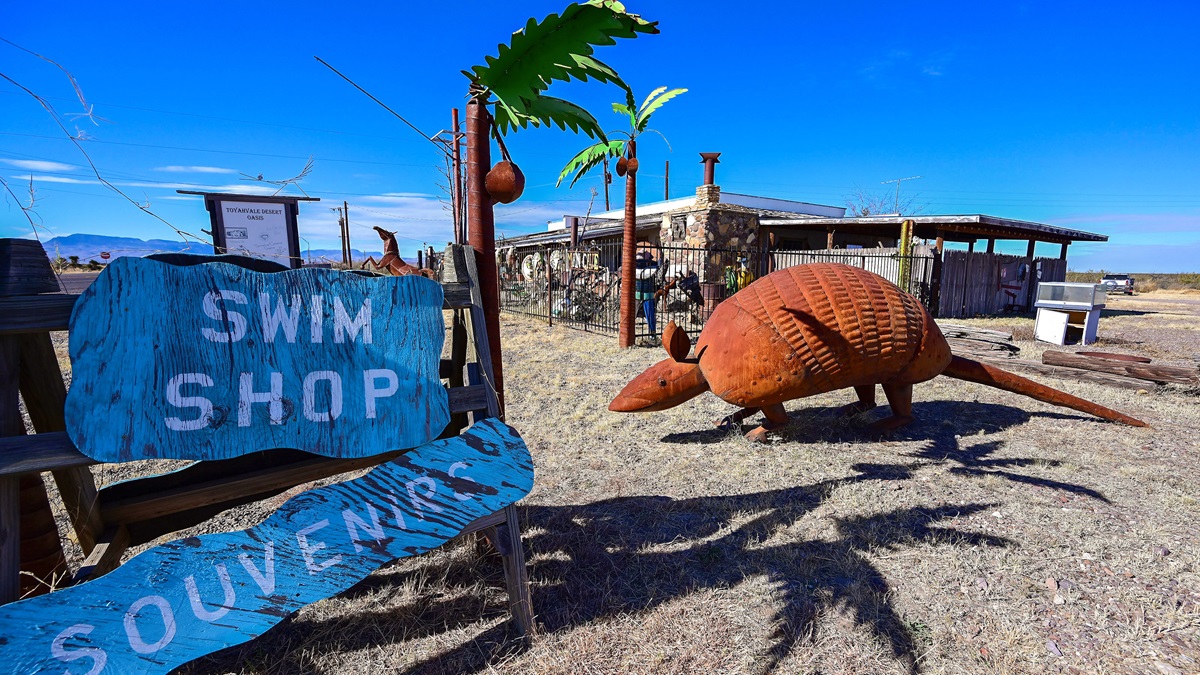
Marfa (population 1,625) is the funky little cousin of Austin, Texas. Here’s where you’ll find live music, art installations both indoors and outdoors, and a slow-paced, walkable town with some amazing restaurants. We stayed at the modestly priced and no-frills Riata Inn. Those craving a bit more atmosphere should head for the Hotel Paisano, built in 1930 and featuring exquisite Spanish architecture, or look for an Airbnb or Vrbo listing. After a day’s flying, sample sotol (a drink fermented from a cactus-like plant) at The Marfa Spirit Co. Dine at the Water Stop on West San Antonio Street, which offers a small but eclectic menu. Cap off your visit by driving 9 miles east to the Marfa Lights Viewing Area, and let us know if you spy the infamous Marfa Lights. Sometimes red, sometimes blue, and sometimes white, the mystery lights appear randomly at night, and no one seems to agree as to what causes them.
Alpine (population 5,982) has a funky vibe similar to Marfa’s, but it also has more of the accoutrements of a bigger city. Custom hat and saddlery stores can be found, along with more traditional destinations such as the Museum of the Big Bend, which explores the area’s shared history with Mexico. The museum is located on the Sul Ross State University campus. Incidentally, some of the university’s more enterprising students in 1981 dragged a school desk to the top of Hancock Hill to create an outdoor classroom. It’s still there—and it is a tourist attraction all by itself, where you can complete a 20-minute hike by signing your name in a notebook on the desk. There are a selection of hotel/motel chains, but for sheer fun we suggest the Big Bend Biker Hotel on West Avenue East. You don’t have to be a motorcycle rider to stay here, but if you are a biker, you’ll appreciate that this hotel has special indoor parking just for your ride. Its loft-style rooms are big and comfortable. Yes, you are staying overtop the Old Gringo biker bar, but you don’t even need earplugs. Downstairs, Old Gringo serves good pub-style food, including something called the Big Gordo that serves two to four people and has pork and ground beef and chicken.
Going deep
 To go even deeper into Big Bend, venture to Terlingua, about 109 statute miles south of Marfa. Terlingua hugs the Big Bend National Park. There are places to land an airplane and spend some time, but each is very different based on your budget and your airplane’s capability.
Terlingua Ranch Lodge (terlinguaranch.com) has its own airport (1E2), with a 4,700-foot dirt/gravel runway. That may give some owners pause, said Morrison. “The propeller on [my 182] has more dings in five years than my friend’s Lance got in 20 because of landing on gravel strips. The horizontal stabilizer taking dings from the gravel—it’s the same thing. If you have a really nice, pretty airplane you probably don’t want to [land there].” Another factor is the length of the runway combined with density altitude, he said.
There’s no fuel. Landing is to the south, takeoff is to the north, thanks to a marked upslope and rising terrain. Lodging ranges from tent and RV campsites to cabin rooms. The ranch’s Bad Rabbit Café is open daily, and it, the cabins, and a swimming pool are within walking distance of the airport. Call ahead to arrange assistance with your luggage once you have landed. A courtesy van is sometimes available, but if you want to be able to explore the area by car, you should rent a car or ask a Texas flying friend to come pick you up.
Thirty nautical miles west is Lajitas International Airport (T89), privately owned for the use of guests and property owners at Lajitas Golf Resort (lajitasgolfresort.com). The airport sells 100LL and Jet A and has a paved, 6,500-foot-long runway. The airport is day VFR only, and 24 hours’ advance notice is required to let them know your estimated time of arrival. And you will want to make that call; it’s four miles from the airport to the resort, and a shuttle will come to transport you and your passengers.
Lodging options start with standard or luxury hotel rooms and go all the way to condominiums and three-bedroom villas. The resort features an 18-hole golf course, horseback riding, a spa, clay shooting, zip lines, mountain biking, and swimming pools.
Big Bend Ranch State Park has an airport (3T9) with a 5,500-foot asphalt runway. Camping is available at the park, but reservations are required, and it’s a “very challenging uphill hike” to haul water, gear, or other equipment from the runway to the campsites, according to a recent comment on ForeFlight. And once you’re here, you won’t be going anywhere—unless your airplane can carry portable bicycles. If you want to get away from it all, this is the way to do it—just remember that there’s no cellphone coverage and no fuel available.
Caution
The airspace in the Big Bend area is uncomplicated—so long as you stay on the U.S. side of the border and remain clear of the Air Defense Identification Zone. The Rio Grande is a good marker to stay within U.S. airspace.
U.S. Customs and Border Protection operates a tethered aerostat radar system off Highway 90. Its cable extends to 14,000 feet msl and it is marked as Restricted Area R-6318, inside the Valentine Military Operations Area.
Density altitude, winds, weather: Texas knows how to dish it out. A breeze that flaps the state flag at 10 to 15 knots the locals consider “light and variable.” And that wind changes directions on you. We watched a tumbleweed skid around Marfa Municipal Airport, then turn around and go back in the other direction. “I’ve seen two windsocks pointing in different directions,” said Mark Morrison.
The U.S. National Park Service notes that the COVID-19 pandemic has created an explosion of visitors to national parks. Peak season for Big Bend is October through April, and the park service urges visitors to consider making the trip at other times of the year.
Is Big Bend worth the effort of getting here? Of course. Texas makes you work for the privilege of viewing its majestic landscape, but you will come away with a greater appreciation for the enormity of the state. My home state of Maryland is 1.5 times larger than New Jersey, but it would fit into Texas 22 times. That’s a lot of sightseeing.
Get your boots on


Related Articles


