Waypoints: Cleared direct
Not always welcome news
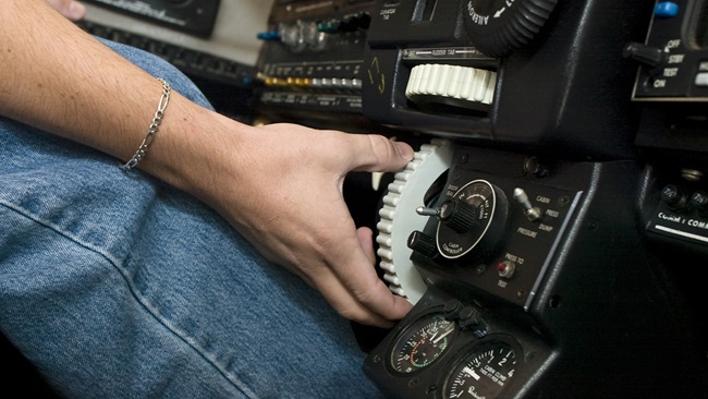
Eyes open wide, I stared at the Bendix/King KNS 80 in the center of the stack. Now what do I do? I asked myself as the 1984 Beechcraft Bonanza A36 continued trucking eastbound toward Frederick, Maryland, some 600 nautical miles away. I had filed the IFR flight plan with the description code of “slant R.” Today that code has a complex meaning, but in the early 1990s it told ATC that you had area navigation (RNAV) equipment that allowed you to fly to any point in space. Few light general aviation airplanes had that capability then and it was a bragging point to have such gear. But the truth of it was that flying direct in the days of VOR/DME was complicated.
I acknowledged the clearance, gulped, and then grabbed the instrument chart on the seat next to me. I was already navigating to a VOR along my route, but the filed route had me zig-zagging from station to station toward Frederick. The controller now expected me to fly a direct route for nearly 600 miles—well beyond the range of any VOR. Not wanting to disappoint, I went to work, mindful of the head-down task ahead and thankful for a quality autopilot.
The trick was to draw a line on the paper chart (you remember those, right?) from your current position to your destination. On a long leg like this one, you might have charts spread across the cockpit—trying to draw a line that crossed from one to the other. Next you would choose VOR/DME stations along the route and, using a plotter, choose a radial that intersected with your hand-drawn route. And then measure the distance from the station to the line. Pencil the radial/distance next to the newly created waypoint and move on to the next one.
With that accomplished you’d then turn to the box—in this case the KNS 80, but there were others. Narco, for example, also had an RNAV system. The KNS 80 could store up to four waypoints. You would carefully select the frequency of the VOR/DME you were using, then enter the radial and the distance. Double-check them all to make sure you don’t go heading off into the hinterlands.
With that, the RNAV computer would create a waypoint on that radial at the selected distance. As we used to say, you were essentially moving a VOR/DME to a new location along the route and then navigating to it. Once reaching that first station, you could then choose the second waypoint already stored and then begin calculating and storing the fifth waypoint along the course in the now-behind-you number one memory slot.
You can imagine the head-down time—and this at a time when almost no light airplanes had traffic awareness systems and no one had terrain warning systems—and most light airplanes either had no autopilots or, if they did, they were rather rudimentary.
And while ATC was expecting you to fly a great circle route, you were not, since that’s difficult to draw on a paper chart. Still, no one seemed to notice or care.
Technology eventually removed some of the tediousness from the process. A couple of companies came out with handheld RNAV flight computers that contained the coordinates for every VOR/DME station. You could enter your starting and ending points and the computer would give you list of stations and radial/distances to create a true great circle route between the points. It all worked great, as long as the batteries didn’t die.
The FAA even created RNAV approaches, which electronically placed a phantom VOR/DME station at the runway end. The FAA would provide the radial/distance points on the approach chart along with vertical navigation guidance.
The FAA’s flight test program assured that signal strength was good for the approach waypoints, but out in the wild, you were on your own to make sure you were high enough and the station near enough to provide a quality position.
I’ve always remembered that flight from St. Louis as the longest RNAV route I had flown at the time. Some airplanes by then had loran receivers; with their waypoint databases, they made flying long distances easier—if not technically legal for IFR purposes. We, of course, backed up our loran route with legal VOR/DME tracking (wink, wink). IFR loran was briefly a thing, but GPS came crashing onto the scene and by 1994 we were flying IFR GPS approaches, also referred to as RNAV approaches. The Wide Area Augmentation System (WAAS) soon came online and we were quickly flying LPV approaches to ILS-like minimums to thousands of additional runways.
Now, “direct to” makes us children of the magenta line, taking all the tedium out of long legs and, to a certain extent, infusing an element of boredom into the flight. Still, though, on legs I’m flying from Point A to Point B, I’m not looking for adventure. Bring on the boredom.
Email [email protected]
@tomhaines29

Related Articles