WX Watch: Polar power
For bad weather down low, check the winds up high.

But I have news. There is no single, free-roaming polar vortex. Instead, there is a huge high-altitude (approximately 30,000 feet msl in the winter, 50,000 feet msl in summer) circumpolar vortex that encircles the entire mid-latitudes of the northern hemisphere, and it typically consists of three to six troughs of low pressure. The troughs extend to the south like lobes and the air beneath them is indeed cold—or at least colder than the warmer air south of them. What’s more, this circumpolar vortex is present year-round. Its boundary—where cold, northern air meets warmer air from the south—moves north and south with the seasons.
The entire works—the polar air and its troughs within the boundary—move west to east in the northern hemisphere, their movement slowly following the rotation of the Earth beneath it. And it’s what goes on within the boundary, otherwise known as the jet stream, that causes much of our airmet and sigmet weather.
Here’s a simplified description of how this often works: Where warmer air from the south meets one of those cold troughs from the north, right-turning Coriolis forces team up to generate high-altitude westerly winds around the bend in the upper-level trough’s axis. They blow the fastest at the apex of the trough, where the battle between pressure gradient forces (which draw air toward the trough’s parent low-pressure center) and Coriolis forces (which move to the right, away from low pressure) are in balance. But once this fast-moving air rounds the bend it often slows down as the pressure gradient slackens. This in turn can cause a divergence of air aloft. To compensate for this, air at the surface converges, which in turn causes rising air, low pressure centers, and their attendant cold and warm fronts.
In the colder months, warm fronts cause plenty of trouble because they cover a large area, often producing instrument meteorological conditions in snow farther ahead of the front’s surface position, snow and ice pellets (sleet) closer to the front, and freezing rain immediately ahead of the front.
Sometimes, when the pressure gradient remains tight after emerging from a trough’s boundary, wind speeds of up to 200 knots can form in jet stream cores. But the tug of war between pressure gradient and Coriolis forces still hangs in there, because if there’s any decrease in wind speed, pressure gradient begins to exert itself and in so doing creates lifting forces. But not for long, because Coriolis force quickly responds in the other direction. The result is the formation of more intense, localized areas of lift aloft and low pressure at the surface—and the heaviest snowfalls and ice storms.
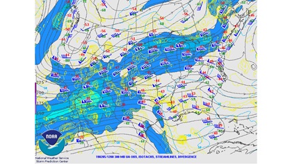
Want to graphically identify the circumpolar vortex’s location? One way would be to call up a constant pressure chart for the 300-millibar pressure surface. This roughly corresponds to an altitude of 30,000 feet—a good altitude to start with for winter weather. A constant pressure level of 200 millibars, or about 40,000 feet, would be a typical altitude for the summer months. The National Weather Service’s Storm Prediction Center has nice charts, complete with wind barbs and color-coded areas showing jet cores. Select the pressure level and time—or video loop.
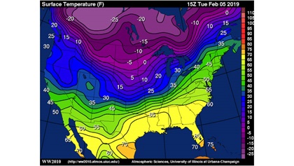
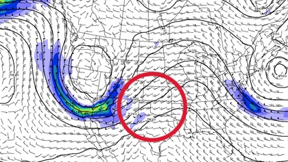
Another way is to use a surface temperature chart. Try the University of Illinois website. See the boundary between the blue and green areas? There’s your polar vortex—er, circumpolar vortex—boundary.
Pilots enduring the drudgery of their first aviation weather courses may say, “Why in the world are we studying the weather at 30,000 feet? I’ll be flying at more like 5,000 feet.” True, but high-altitude dynamics dictate the worst flying weather at lower altitudes. Winter or summer, that polar boundary and its high-speed winds can put you in turbulence, icing conditions, or thunderstorms, and top it all off by giving you instrument conditions for your takeoffs or landings.
Email [email protected]