Flying eyes on the floodgates
Hovering my quadcopter below floodgates releasing millions of cubic feet of water, I could not help but marvel once again at the beauty and power of Mother Nature.
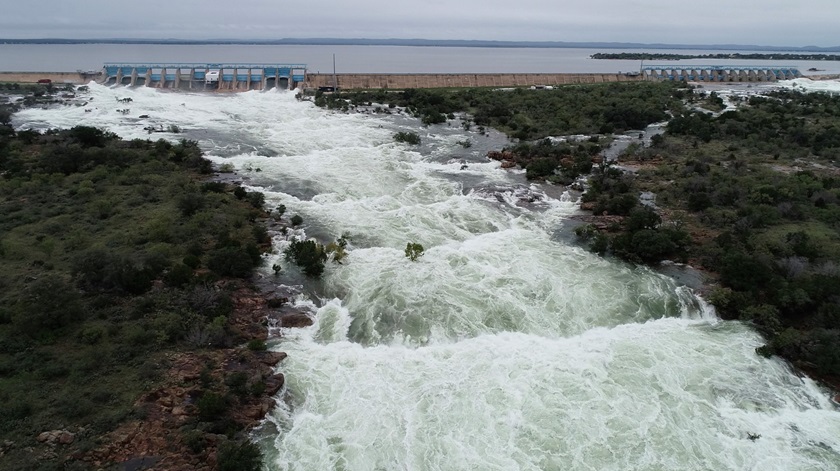
She has unique ways of creating photo opportunities for unmanned aircraft systems, from the predictable sunrises and sunsets to much more dramatic events. This past October, persistent heavy rains over the Texas Hill Country west of Austin forced the Colorado River out of its banks, flooding homes, destroying a bridge and prompting carefully planned releases of water from the series of dams that created the Highland Lakes.
Like hundreds of other Austinites who flocked to the closest public access points around the dams for ground-based photos and video shot through chain-link security fences, I packed up my photo gear, including my drone, to spend the day gathering keepsake images of swollen lakes and rushing, rising waters.
Dams are critical infrastructure, and thus have UAS restrictions above and around them. I was prepared to do my best from a distance when a phone call from the Lower Colorado River Authority changed this outing to a commercial endeavor at the behest of those who operate the dams and are charged with managing the waters of the lower Colorado River basin. Over a period of days, I accompanied LCRA videographer Deborah Cannon, who is also a certificated remote pilot and functioned as my visual observer (VO) and director. We worked at the base of dams, from the top of them and, of course, over them. We scripted each flight at each dam prior to launching.
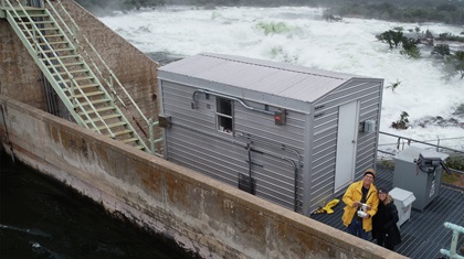
The sheer volume of water that surged from these structures, Buchanan Dam in particular, was a phenomenal sight. A preflight for each of these missions involved logistical considerations including rain, potential clouding of my camera lens, and operating in thick spray from roiling whitewater. Rain continued to fall intermittently from the gray, overcast skies, once forcing a quick landing and hasty retreat to the car. It’s not really known how much moisture a drone can endure before it decides to call it quits, but I had no desire to be the test case and end the job with little to show for it.
Since some of these dams produce hydroelectric power, there are hefty transmission lines running from the structures. While the drone would not likely even scratch them, the quad would not have survived an encounter. Having a second set of eyes to helped me remain clear of those lines while skimming the surface of the water, then climbing steeply over the tops of the structures. Cannon helped manage the shot list as well, to ensure I was meeting the client’s needs.
It occurred to me as I flew from the calm but full lake side of a dam to a raging river on the other that this mission was also unique for its lack of people in proximity. The lakes were closed, and secured perimeters for the most part kept others away. My greatest concern became losing the drone by getting caught in some of the water as it crashed against the river bottom and spewed high into the air. An occasional radio tower also loomed nearby, something taken into account during preflight planning. The notion of losing the drone and the visuals for the client prompted frequent changing out of memory cards as I shot, so that each “money” shot was safely in a coat pocket (it was cold, by the way) before the next launch. With each launch, I flew lower and lower to the water to better scale the rapids against the trees as the water rushed by. Looking directly into an open floodgate from water level is not a view to pass up. Once again, my VO was instrumental in maintaining situational awareness, also reminding me that she was not replacing my expensive equipment if it went down river. Water droplets on the lens forced a couple reshoots after drying the glass.
Another unique aspect to this mission was that launching from the top of Buchanan Dam made that the home point, or zero agl. Thus, once clear of the dam superstructure and descending to the waters below, the altimeter readouts were negative. Between the sloping terrain and inability to determine an accurate base for the water, we were left with the video telemetry and two sets of eyes to determine how close to the water we were. Once again, if ever there was a case for a VO, this was one of them. I was also thankful for the hours of practice over dry land, close to obstacles and low to the ground. The footage and stills we made from these flights reminded me that drones are not just cheaper alternatives to a helicopter—they are sometimes the safer platform for work in cramped quarters and low altitudes.
I would, however, suggest that drone makers consider adding tiny windshield wipers.
Related Articles


