Viva la VOR
The VOR is dead. Long live the VOR.

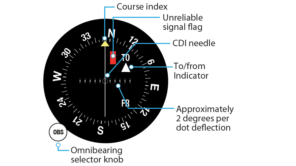
VOR stands for very high frequency (VHF) omnidirectional range. These ground-based navigational aids (navaids) transmit in all directions on a VHF frequency band of 108.0 to 117.95 MHz. Courses from the station are called radials and are numbered 001 through 360, correlating with degrees from magnetic north. Pilots can tune the frequency of a nearby VOR on receiving equipment and display the course to the tuned VOR on an instrument such as a course deviation indicator (CDI) or horizontal situation indicator (HSI).
Over the next several years, the FAA plans to decommission 308 VORs, out of the 957 in the United States; those remaining will be used as a backup system in the event of a satellite outage. It’s important to have a backup—and to know how to use it. But there’s another reason VOR navigation is relevant. Many rental aircraft and used general aviation aircraft on the market aren’t equipped with GPS navigators. If you only learn how to navigate with a GPS, how are you supposed to know where you’re going?
Private pilot Greg Vertise had a lightbulb moment the first time he rented an airplane. “Once I became a private pilot, I rented a Cessna 172 from a local airport,” he said. “I thought I knew much more than I did, mostly because I took lessons from a flight school that had the newest airplanes and technology money could buy. I learned a lot. But I didn’t know how to confidently navigate using VORs. Obviously, there were a few things I took for granted.”
Jason Hammond had a similar experience as a freshly minted private pilot. “I had to learn VOR navigation on my own time. I asked my flight instructor several times if we could or needed to go over VOR navigation again, because I wasn’t confident in my skills. He told me I didn’t need to know it anymore because it was obsolete. I felt embarrassed to ask again, so I researched it myself.”
Under visual flight rules, you don’t need GPS—or any other type of electronic navigation equipment—to get to your destination. Electronic navigation systems such as GPS and VOR comprise just one of three major methods of navigation. Dead reckoning is the calculation of one’s position by direction and distance from a known position. Pilotage is navigation by reference to visible landmarks—another good reason to keep your eyes outside the aircraft in flight. Overreliance on one piece of navigation equipment can lead to trouble; even while using GPS or VOR, you should keep track of your position by using landmarks and a sectional chart.
“I remember getting lost within 10 minutes of leaving the airport during a lesson with my instructor,” Hammond said. “I realize I should have been more aware of the local landmarks around me, but I felt so invincible with the GPS that I thought I could never get lost. Since then, I’m always on the lookout for landmarks on my route, and I write them down in a notebook so I can always use them again. And I always use VORs to navigate.”
Many pilots appreciate the value of efficiently using VOR navigation and pilotage. Jill Turnberry, a student pilot from Hartford, Connecticut, navigates using VORs and landmarks along her route. “I’ve flown in several different airplanes and I’ve never seen a GPS device in any of them,” she said. “I guess that’s probably why I’ve never used one. I’m not really interested in looking at a tech device while I fly, anyway—I’d much rather enjoy the view.”
Needle Position
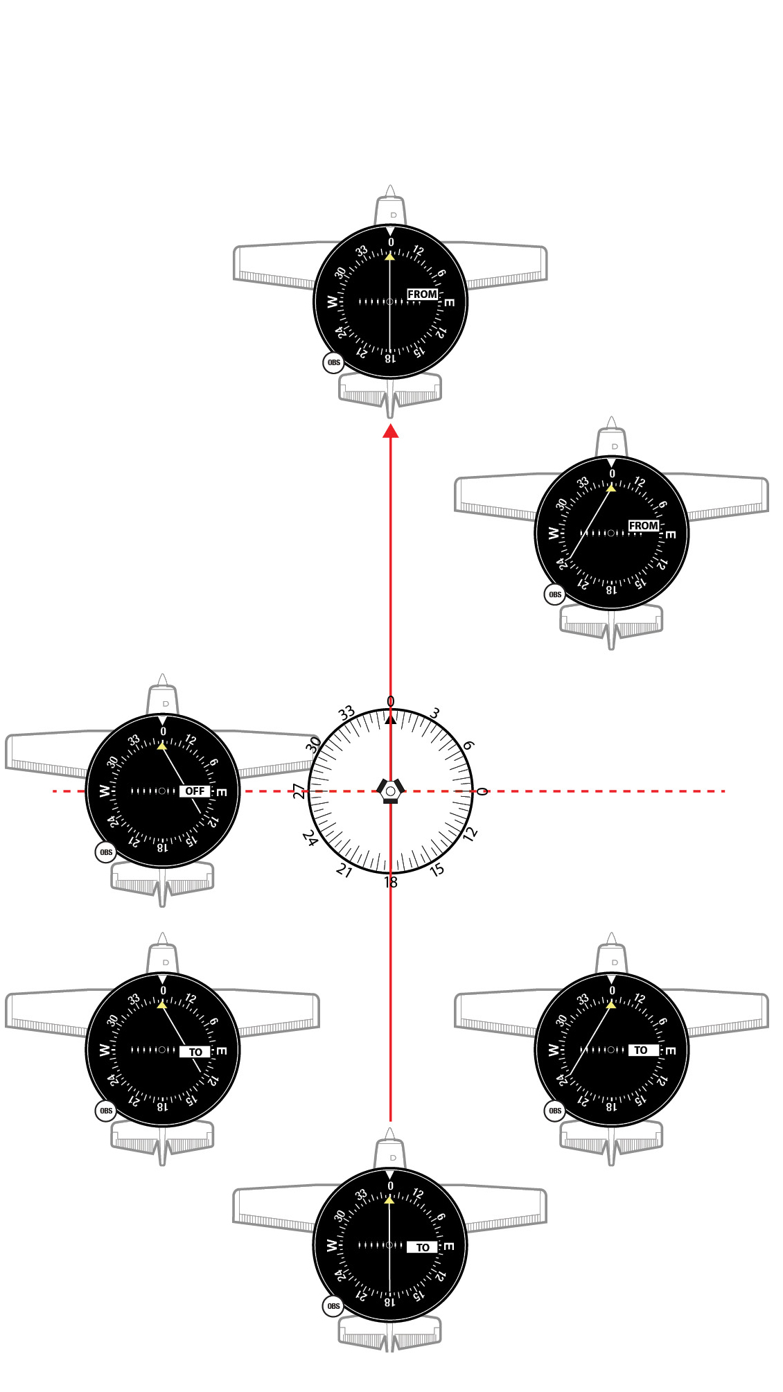
Tracking a radial
In calm wind, tracking to a station is as simple as tuning and identifying the station, centering the needle, and turning to the desired heading. In the real world, you must compensate for wind.
1. Tune to the frequency of the desired VOR and listen for the Morse-code identifier to confirm you’re receiving the correct station.
2. If you wish to fly toward the VOR, rotate the dial until the CDI needle centers and the TO/FROM indicator reads TO. Don’t confuse your heading with the radial you’re flying. Radials emanate out from a VOR, so if you’re flying inbound to the station, your course will be 350 degrees and the instrument will read 350 TO. When flying away from the station, the flag will say FROM and the course will match the selected radial.
3. Turn to the heading indicated on the azimuth dial. If there’s wind, the aircraft will drift off course and the needle will gradually move off center.
4. To return to the desired radial, turn toward the needle. Make small adjustments to avoid overshooting the radial.
5. When the needle centers, turn back toward the original heading—but not all the way. You must set up a wind correction angle to compensate for drift.
6. If the needle drifts in the opposite direction, your wind correction angle now is too great. Repeat the process, making progressively smaller heading corrections.
7. The needle will be come more sensitive as you approach the VOR. When flying over the VOR, the CDI fluctuates, and then the TO indication changes to FROM.
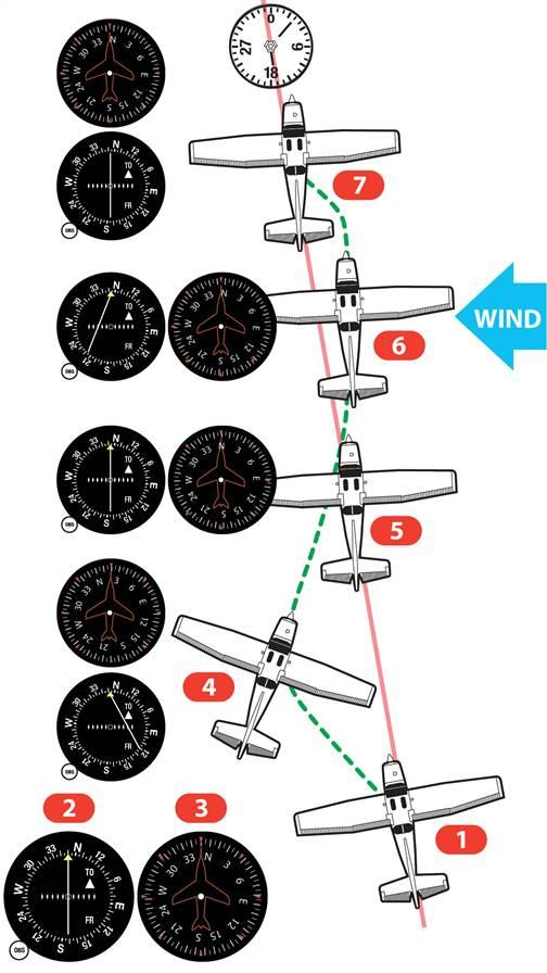
 Intercepting a radial
1. After identifying the station, center the CDI to find your current radial and confirm that TO or FROM is displaying correctly.
2. Turn the OBS to the desired radial. The needle will deflect left or right.
3. Decide on an intercept angle. It will depend on how close you are to the desired radial and to the VOR. A 90-degree intercept angle would get you to the radial the fastest, but it’s also easy to overshoot the radial when turning on course from perpendicular. A 45-degree intercept generally is more manageable.
4. Fly the intercept. Once you’ve selected your intercept angle, turn to the heading that will give you that angle from the desired course. When the CDI begins to center, turn to the desired course and track the radial.
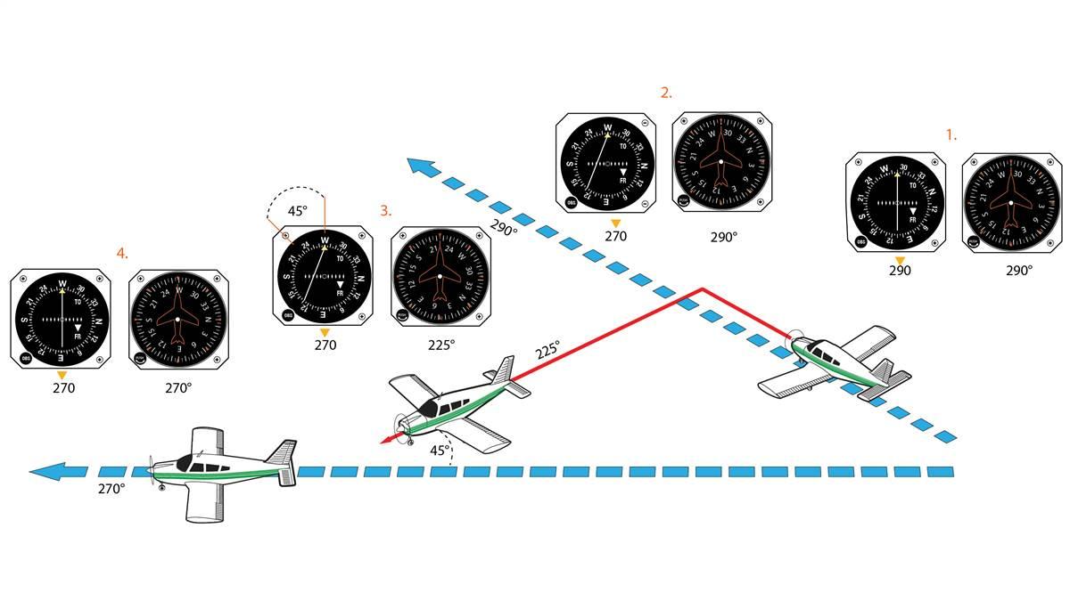
Know your navaids
Ground stations used for VOR navigation include VORs, VORs with distance measuring equipment (DME), and VOR with military tactical air navigation (TACAN) equipment (VORTAC). Although these are indicated by different symbols on a sectional chart, the VOR indicator behaves the same regardless of station type.
Related Articles


