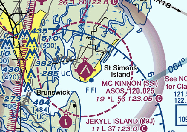
It’s early morning as a pilot preflights an aircraft at Malcolm McKinnon Airport in St. Simons Island, Georgia. Visibility is good, but the ceiling reported by the automated surface observing system (ASOS) is 900 feet. Can a pilot depart or enter the airspace under VFR?
That depends on what time it is.
Checking out Malcolm McKinnon on the Jacksonville Sectional, the pilot would observe a dashed magenta line encircling the airport symbol. That signifies that Class E airspace reaches to the surface. In surface-based Class E airspace, VFR minimums are a 1,000-foot ceiling and three miles visibility.
But, further inspection of the chart reveals this note near the airport symbol: "See NOTAMS/Directory for Class E (sfc) eff hrs)." Looking up the airport’s listing in the airport/facility directory produces this important note: "AIRSPACE: CLASS E svc 1100–0259Z‡; other times CLASS G."
If the flight is ready to depart before 1100Z (7 a.m. Eastern Daylight Time), Class G minimums apply, and the flight may proceed—provided there is no notam to the contrary.
Even within the small charted circle of Class E airspace, other uncommon charting characteristics or symbols draw the eye, perhaps sending a pilot to a reference source such as the Aeronautical Chart User's Guide to research the meaning.
What does the circle along the shore just south of the airport represent? You're correct if you responded that it is the symbol for a marine light. (It is the 104-foot-high lighthouse and museum of the Georgia Coastal Historical Society operating nightly and during bad weather.)
How would one research the meaning of the letters F and Fl that appear beneath the lighthouse symbol? The abbreviations (fixed, and flashing) are found on a list of features of marine lights on Page 25 of the Aeronautical Chart User's Guide.
There are obstructions just west of the airport; note that one contains the notation UC ("under construction or reported: position and elevation unverified," according to the sectional chart legend).
Just west of the Class E airspace is the eastern boundary of a large complex of special-use airspace including several military operations areas, and adjacent restricted areas. Be sure to check hours, altitudes, and types of operation; know how to request activity updates by radio from flight service (see the communications box for the Brunswick VOR) or via the Coastal MOA Advisory Service, if you plan to transit.


