Air Traffic Services Brief -- Wide Area Augmentation System (WAAS)
The Issue
The Wide Area Augmentation System (WAAS) is a navigation system comprising satellites and ground stations that improve the accuracy of the Global Positioning System (GPS). With WAAS on board the aircraft, pilots are authorized to fly Area Navigation (RNAV) throughout the United States under Instrument Flight Rules (IFR) without reliance on ground-based navigation aids. WAAS is capable of supporting all phases of flight, including instrument approaches to minimums like those of an Instrument Landing System (ILS). WAAS is a cost-effective navigation system that general aviation pilots can use to improve safety and enjoy increased access to airports in all weather conditions.
Background
The Federal Aviation Administration (FAA) began developing WAAS in 1995. A 1998 study by the Johns Hopkins University Applied Physics Laboratory concluded that WAAS would allow pilots to rely on GPS as a sole means of navigation. Also, an independent review board administered by the Institute for Defense Analyses concluded in a January 2001 study that WAAS is critical to both aviation and other users. The FAA authorized pilots to use WAAS for IFR operations in July 2003. In September 2003, the first WAAS approaches were published with minimums as low as 250 feet above the airport.
AOPA has been a strong advocate of WAAS since the program's inception. It is AOPA's position that WAAS benefits will far outweigh the costs of the system's development, offering cost savings for both users and the FAA in the future. However, AOPA maintains that the FAA must remain aggressively focused on delivering the benefits that AOPA members desire: approaches with vertical guidance to every airport.
How WAAS Works
There are 38 widely-spaced reference stations throughout the United States, Canada, and Mexico that collect GPS data. The extremely accurate receivers evaluate the quality of the GPS signal and relay that information to three master stations. They receive the information and determine what differential GPS information is needed to improve the accuracy of GPS to the quality needed for precision navigation.
The master stations then transmit the correction data through a ground transmitter up to geostationary satellites that "hover" over the United States. These satellites broadcast the GPS correction signal, which is received by a WAAS-capable satellite navigation receiver aboard the aircraft.
The WAAS receiver uses the WAAS signal to calculate the improved accuracy and integrity information, ultimately improving its known GPS position. Simultaneously, the receiver uses WAAS to ensure that the pilot will not be receiving false or misleading navigation information.
The Benefits of WAAS
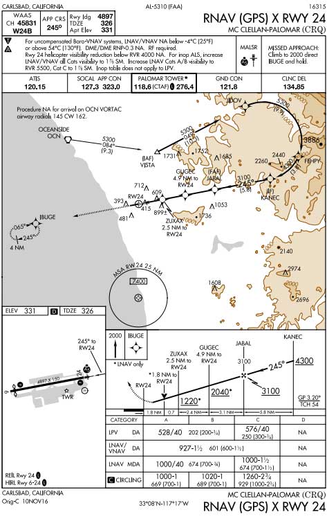
Given its enhanced approach capabilities, access to airports will increase. The FAA is publishing WAAS-enabled Localizer Performance with Vertical guidance (LPV) approaches to general aviation airports. They are frequently providing minimums of 200 feet and one-half mile. The FAA does allow an LPV procedure with a decision altitude equal to or less than 300 feet agl to be used to demonstrate precision approach proficiency. The LPV approaches provide unprecedented access to general aviation airports, at a fraction of the cost of traditional ILS approaches. In 2016, there were more than 90,000 aircraft equipped with WAAS and capable of flying any of the nearly 4,000 LPV procedures published. Additional information on the different kinds of approach procedure lines of minima can be found below. The full list of WAAS approaches is available on the FAA's Satellite Navigation website.
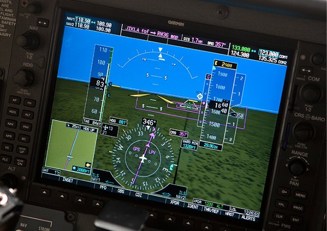
Caption: An avionics display shows an LPV procedure being flown.WAAS also supports advisory electronic glidepath capabilities to many runways served by a non-precision GPS approach. The vertical descent angle will be published on the procedure, should obstacles be clear, allowing pilots to use vertical navigation to descend to the published minimum descent altitude. This WAAS-avionics-system-generated “advisory” glidepath can reduce pilot workload and promote a stabilized approach, although, pilots are cautioned to not treat the published minimum descent altitude as a decision altitude when using the advisory glidepath. In other words, pilots must not descend below the minimum descent altitude while using an “advisory” glidepath until they meet the requirements of FAR 91.175, which includes the aircraft is continuously in a position to land, sufficient flight visibility, and runway environment in sight.
WAAS promotes smart aviation policy. There are no ground navigation systems (e.g., ILS) to purchase or maintain; therefore, the cost of installing a WAAS approach is less than 10 percent of an ILS. The annual ILS maintenance cost can be as high as $100,000 while the cost to maintain a WAAS approach is less than $3,000 per year.
WAAS falls within the FAA’s category of Performance Based Navigation (PBN) because this system uses satellites and onboard equipment to navigate. This onboard equipment conducts performance monitoring and can alert the pilot to position errors, which allows it to meet the requirements for more advanced forms of RNAV or Required Navigation Performance (RNP). The navigation specification, which is based on the aircraft and aircrew capabilities, determines what RNAV or RNP specification can be flown. Although there are few RNP procedures that are publicly available—in other words, that do not include “Authorization Required” in the procedure title—an increasing number of procedures utilize RNP design aspects. One characteristic used increasingly in the National Airspace System (NAS) is the use of Radius-to-Fix (RF) legs. RF legs allow for instrument procedures to include turns along a narrowly defined path, which reduces the obstacle evaluation area and allows for lower altitudes to be flown.
Because WAAS is permitted as a sole-means navigation system, general aviation reliance on ground-based navigational aids for instrument flight is reduced. Pilots equipped with WAAS can flight plan their alternate airport based on LNAV and Baro-VNAV lines of minimum versus legacy instrument approaches that rely on ground-based navigational aids. Over the next decade, the use of ground-based navigational aids will continue to decline and their role will increasingly become an optional enroute navigation backup as part of the VOR Minimum Operational Network.
WAAS and GPS Technical Standard Orders (TSO)
When pilots begin shopping for different GPS systems, they will encounter a mix of FAA-issued technical standard orders (TSO). A TSO is the minimum performance standard to which the avionics are designed and certified. A TSO authorization allows the production of a system and also helps pilots to understand the system’s performance capabilities. Below is a brief description of WAAS and GPS systems.
Pilots should check with their avionics manufacturer and consult their aircraft flight manual (AFM) and flight manual supplement for information specific to the capabilities and restrictions of each system. Whether using WAAS or just a GPS navigator, it is important to check for GPS outages and interference events, and plan flights accordingly. The FAA requires pilots flying under IFR with GPS and WAAS systems to ensure their database is up to date (revisions are issued every 28 days) and that the procedure to be flown is retrievable.
GPS-Only System (non-WAAS)
- TSO-C129 – Airborne Supplemental Navigation Sensors for Global Positioning System Equipment using Aircraft-Based Augmentation
- TSO-C196 – Airborne Supplemental Navigation Sensors for Global Positioning System Equipment using Aircraft-Based Augmentation
TSO-C129 and C196 equipment allows you to file RNAV (equipment suffix /G), conduct point-to-point flight, fly T and Q Routes in the contiguous United States (restrictions apply in Alaska), and conduct an LNAV or LNAV/VNAV (if equipped with Baro-VNAV capability) approach. Another benefit is you can take advantage of the GPS substitution rules for certain ground-based navigational aids.
GPS receivers with Fault Detection and Exclusion (FDE) allows pilots to file to either their destination or alternate airport based on GPS lines of minima, but not both. In other words, equipment appropriate to the approach—for example, VOR or ILS—must be installed and operational to use for an approach at either the destination or alternate airport. Also, remember that GPS is supplemental for enroute operations—you must still have navigational equipment installed that is satisfactory for the route of flight. Pilots solely using GPS equipment for RNAV operations must conduct a GPS RAIM check for their route of flight.
WAAS/GPS System
- TSO-C145, Airborne Navigation Sensors Using the Global Positioning System Augmented by the Wide Area Augmentation System
- TSO-C146, Stand-Alone Airborne Navigation Equipment Using the Global Positioning System Augmented by the Wide Area Augmentation System
For flights under 14CFR Part 91, TSO-C145 and C146 WAAS equipment can be used as a stand-alone navigator (remember to check AFM, flight supplement) with no additional equipment required to be installed; pilots may fly LP, LPV, LNAV, LNAV/VNAV approaches; and RF legs. WAAS enhances the reliability of the GPS system and thus no longer requires a RAIM check if WAAS coverage is confirmed to be available along the entire route of flight; in this case the pilot can plan the flight to a destination and file an alternate airport using only the WAAS navigation capabilities.
Additional FAA Resources
The FAA provides several Advisory Circulars (AC) that cover the operational and airworthiness requirements for RNAV and WAAS systems. Pilots should review the pertinent ACs to understand the capabilities and limitations of their system.
- AC 20-138, Airworthiness Approval of Positioning and Navigation Systems;
- AC 90-100, U.S. Terminal and En Route Area Navigation (RNAV) Operations;
- AC 90-101, Approval Guidance for RNP Procedures with AR;
- AC 90-105, Approval Guidance for RNP Operations and Barometric Vertical Navigation in the U.S. National Airspace System and in Oceanic and Remote Continental Airspace;
- AC 90-107, Guidance for Localizer Performance with Vertical Guidance and Localizer Performance without Vertical Guidance Approach Operations in the U.S. National Airspace System;
- AC 90-108, Use of Suitable Area Navigation (RNAV) Systems on Conventional Routes and Procedures.
The FAA’s roadmap for increasing PBN procedures is discussed in the PBN NAS Navigation Strategy 2016. A key aspect of the strategy is to update procedure design policy to allow an increase in vertically guided procedures, like LPV, to more runway ends. Pilots can learn more about requesting the establishment of a new instrument approach by reviewing AOPA’s fact sheet on the topic.
AOPA’s Position
AOPA continues to advocate for LPV and LP approach proliferation as well as for the updating of legacy guidance and regulations to ensure pilots can take full advantage of WAAS. The FAA needs to generate a comprehensive strategy that results in LPV and LP approaches at every suitable runway and that furthers the utility of WAAS systems.
Updated February 8, 2017