VFR WAYPOINTS/CHECKPOINTS FOR MOUNTAIN PASSES
HOW TO REQUEST POINTS FOR HIGH-TRAFFIC PASSES
The Issue
Mountain passes are a standard feature on VFR flight charts, letting pilots know that they are crossing the high point while traversing a mountainous area. While these features are important, and critical in preflight planning, they are in some cases buried deep in a broad mountain range.
Mountain passes are primarily of interest to pilots flying under visual flight rules when either the weather or aircraft limitations don’t allow climbing high enough to clear the terrain and fly a direct route.
Providing tools to VFR pilots to (a) safely navigate through mountain passes, and (b) communicate with each other to reduce the risk of mid-air collisions when flying in confined terrain, are the challenges to be addressed. This document explains recent changes that allows the charting of waypoints associated with mountain passes, how these features may be used, and the process to request additional waypoints associated with them.
Background
In 2019, AOPA approached the FAA Aeronautical Charting Meeting with a proposal to review attributes associated with mountain passes on VFR charts. The FAA subsequently adopted a Recommendation Document (#19-02-341) which focused on mountain passes in Alaska. This lead to changes including the addition of new passes that were frequently used by pilots, but not charted, as well as removal of a pass that was not used. It also explored the topic of adding VFR checkpoints as a tool to help pilots navigate to and from the passes.
A working group was formed with representation from industry and government that explored this topic and lead to a proposed a policy change, allowing the use of VFR waypoints and checkpoints as a navigation aids for high-traffic mountain passes. The policy was adopted in November 2022 and three mountain passes in the Brooks Range in northern Alaska had these features added in April, 2023. As a national policy, this process may be used in other high traffic mountain passes.
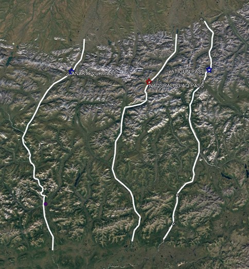
Major mountain passes have long been marked on VFR flight charts with an hourglass symbol and labeled with the name and elevation of the pass. In some locations, a pilot may fly upwards of a hundred miles in confined terrain before crossing a mountain pass and reaching lower and more open conditions on the other side. (Figure 1). Depending on the terrain, navigating to the actual pass may not be straight forward, requiring multiple decision points while the pilot follows drainages into increasingly higher terrain.
To address this issue, FAA now allows the use of VFR checkpoints and/or waypoints to help the pilot maintain situational awareness from the time they first enter confined terrain—such as flying up a mountain valley—until they exit the pass and continue on to their destination.
An additional safety benefit is that these waypoints provide a network of named features which pilots may use to make VFR position reports on a Common Traffic Advisory Frequency (CTAF), helping to reduce the risk of mid-air collisions. When following valleys below ridge top level to cross higher terrain, aircraft may be concentrated in narrow corridors and are generally too low to be seen by radar or to take advantage of flight following services from Air Traffic Control. Having a set of named locations to use in issuing position reports lets local pilots, and those unfamiliar with the area, share their positions with one another.
How it works
Two kinds of checkpoints are used to provide navigational assistance. The example below illustrates how these different waypoints are used. Prior to entering confined terrain, such as a river valley leading to the pass, a collocated VFR Waypoint/Checkpoint is used. This feature is indicated on the chart with a magenta flag and has a name and an identifier, which may be found in the GPS database. Once inside confined terrain, however, only standard VFR Checkpoints are used. These also are depicted with a magenta flag and a pronounceable name. These do not, however, have a five-letter identifier, and aren’t included in the GPS database.
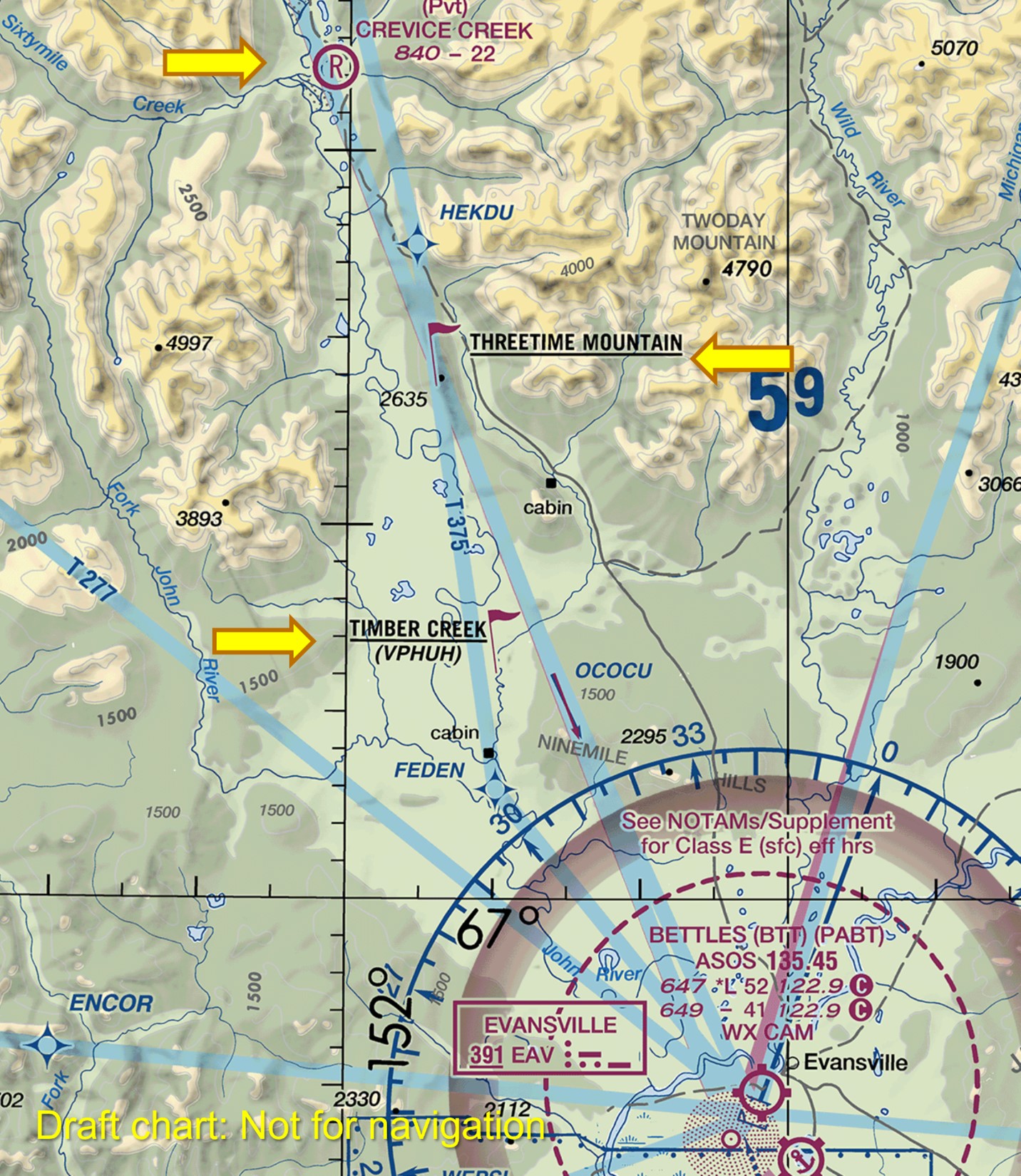
Figure 2 illustrates the use of these charting features for a flight northbound through Anaktuvuk Pass in the central Brooks Range. Departing Bettles (PABT), a collocated VFR Waypoint/Checkpoint is shown at Timber Creek, a small stream flowing into the John River. This location is only a few miles outside of Bettles, well before entering confined terrain. It confirms that the pilot is in the valley following the John River and not the Wild River, which is slightly to the east. The next point, about eight miles further upstream, is Three Time Mountain, a prominent terrain feature on the landscape. The airstrip at Crevice Creek provides the next reference point, marking entry into the increasingly narrow terrain of the Brooks Range.
Further along the valley, Figure 3 depicts the checkpoint labeled Hunt Fork Lake. This is a significant location, as continuing to the northwest up the Hunt Fork feels like more open terrain - but to get to the actual pass, pilots must bear to the right. This lake is also a popular location for float plane operations as a drop off point for boaters floating this scenic river in the Gates of The Arctic National Park. It is also a good location to provide a position report on the CTAF frequency and to be on the lookout for other aircraft that might be maneuvering in the area.
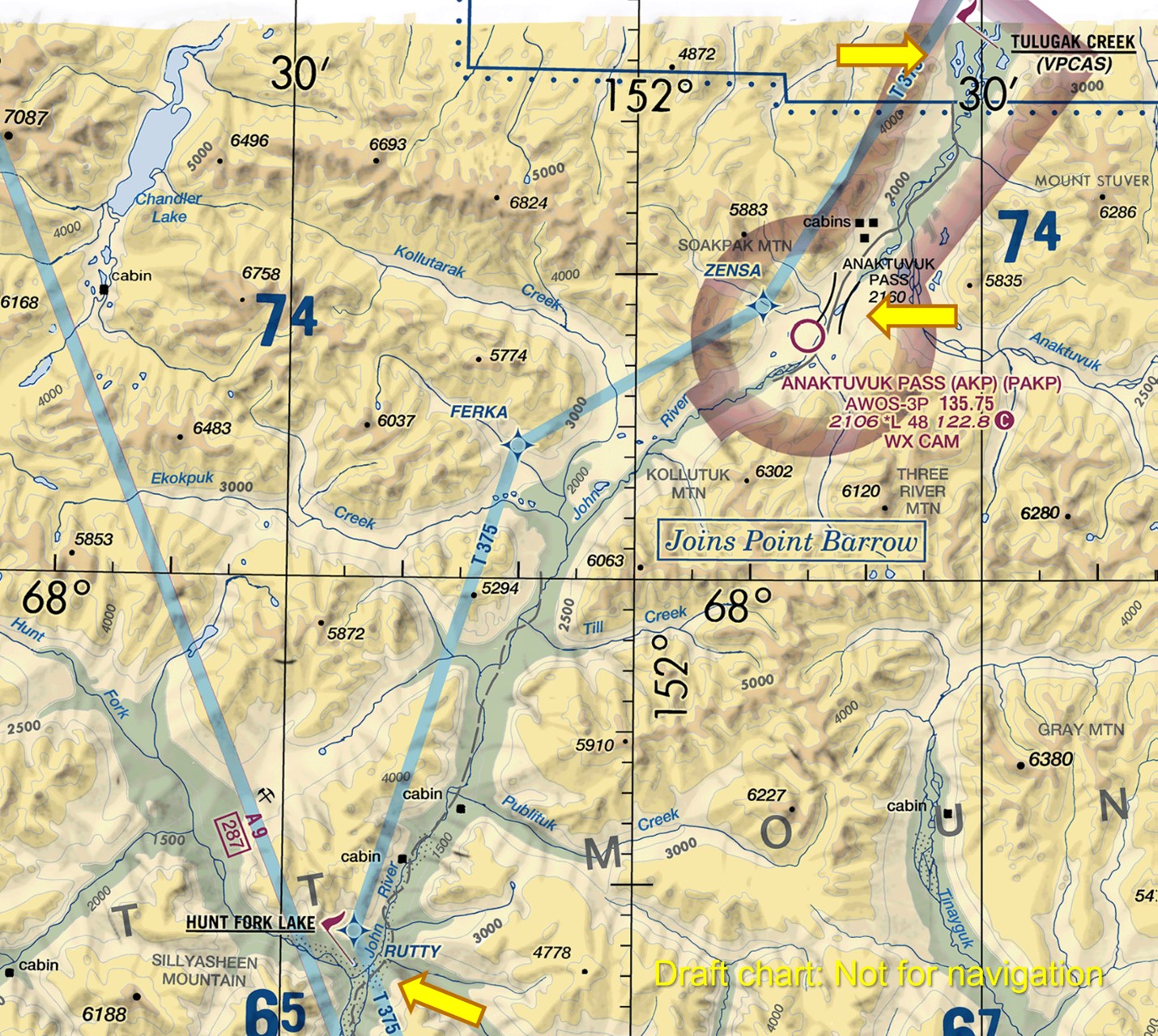
Figure 3. The VFR Checkpoint at Hunt Fork Lake signals the need for a course change to the northeast and is also a popular lake for float planes to drop boaters floating the John River. Tulugak Creek, north of Anaktuvuk Pass, marks the end of confined terrain when flying northbound.
The pass itself is indicated by the mountain pass symbol just northeast of the Anaktuvuk Pass Airport (PAKP) on the chart. Once over the pass, headed down stream on the Anaktuvuk River, Tulugak Creek is depicted as a collocated VFR Waypoint/Checkpoint, signifying the end of confined terrain.
A word of caution: these waypoints do not constitute a defined route that would offer terrain clearance and minimum altitudes to fly while transiting a mountain pass. They are not designed to be used as an IFR style, point-to-point route. They are strictly visual reference points, intended to help with situational awareness to help navigation, and to facilitate CTAF calls—increasing one’s awareness of other traffic that may be sharing the airspace.
Implementation
FAA charting policy now allows the use of VFR check points and waypoints to be used in the manor described above for high-traffic mountain passes. To have these features added to the VFR charts requires submitting a request to the FAA. Requests may be submitted to the FAA Operational Support Group in the area where the mountain pass is located.
|
FAA Operations Support Group |
Email address |
|
Western Area |
|
|
Central Area |
|
|
Eastern Area |
To find the appropriate FAA Service Center see: https://www.faa.gov/about/office_org/headquarters_offices/ato/service_units/mission_support/sc
AOPA Position
AOPA encourages exploring the use of this new policy to establish VFR waypoints and checkpoints for other high-traffic mountain passes. If you think this is appropriate for passes where you operate, we recommend reaching out to local pilot groups and/or users that fly in the area to vet the idea and identify locations and placenames that would be suitable waypoints. We also recommend considering both navigational needs and good locations for facilitating VFR position reports used for collision avoidance. In most cases, local operators already have local landmarks and names in common use. Having these charted should improve safety and be especially helpful for transient pilots who are not familiar with the area.
AOPA would like to thank the Alaska Airmen’s Association, Alaskan Aviation Safety Foundation, FAA, the military, other federal and state governmental organizations that helped craft and implement this change.
References:
FAA Joint Order 7210.3 See Section 8. VFR Waypoint Chart Program
Posted: July 26, 2023