FAA Information Effective: Mar 20, 2025
All information is provided from the FAA unless otherwise noted.
(W75) Hummel Field
1 rating | 4 reviews
Overview
Attendance:
Attended
Year-round, 7 Days a Week,0800-1600
FAA
Runways:
01/19
Runway length: 3,150 ft (960 m)
Elevation:
30 ft (Estimated)
Tower:
No
Airspace:
Unknown
Fees:
Timezone:
EDT (UTC-04:00)
Sunrise-Sunset:
6:37 am - 7:38 pm
Evening-Morning Civil Twilight:
8:05 pm
(Today)
(Today)
-
6:09 am
(Tomorrow)
(Tomorrow)
Minimum Fuel Prices:
$4.99
100LL (self)
Runway
Satellite
Sectional
FBOs
Submit New FBO
Hummel Field
No ratings | Be the first to review this business
Services Offered:
$4.99 | 100LL | self
Location:
On field: SE
Phone:
(804) 758-0538
Freq. Monitored:
UNICOM: 123
Fees:
Landing, Parking, Tie Down, Other
Flight Training
Submit New Flight School
Other businesses
Submit New Business
AOPA Travel Discounts 
FlightBridge is the ultimate all-in-one travel booking platform built for the general aviation community. AOPA Members receive free access to FlightBridge with AOPA discounted rates automatically applied. Members save an average of 30% on hotel bookings! Learn more about FlightBridge HERE.
Local Food/Lodging/Activities
Local Attractions
Local Activities
Restaurants
Hotels and Lodging
Travel Discounts
Pilot House Inn and Restaurant
2737 Greys Point Rd, Topping, VT 23169
(804) 758-2262
2324 Greys Point Rd, Topping, VA 23169
(804) 758-0605
784 Locklies Creek Rd, Topping, VA 23169
(804) 758-2871
3601 Greys Point Rd, Topping, VA 23169, Topping, VA 23169
(804) 758-2485
W75
Pilot House Inn and Restaurant
Rudy's
Merroir Tasting Room
Grey's Point Camp Guest Center
Flying Clubs
Submit New Flying Club
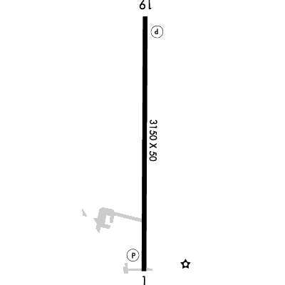
Runway 01/19
Dimensions:
3,150 × 50 ft
(960 × 15 m)
(960 × 15 m)
Weight Bearing Cap:
Single wheel: 13,000 lbs
Surface:
asphalt, no surface treatment, in good condition
Runway Edge Lights:
Medium
Comments:
n/a
| Designator: | 01 | 19 |
| Elevation: | 29.3 ft | 22.4 ft |
| Heading: | 010° magnetic 000° true | 190° magnetic 180° true |
| Gradient: | 0.22% down | 0.22% up |
| Traffic Pattern: | Left Pattern | Left Pattern |
| Markings: | non-precision, in Good condition | non-standard, in Good condition |
| Approach Lighting: |
|
|
| Displaced Threshold: | n/a | n/a |
| ILS/LOC: | n/a | n/a |
| Obstructions: | Tree, 173 ft Left ft of center, 92 ft high, 1,463 ft from end, 13:1 clearance slope | Tree, 178 ft Right ft of center, 67 ft high, 1,713 ft from end, 22:1 clearance slope |
| Comments: | 18 Ft Building Located 200 Ft Fm Pavement End, 204 Ft Right of Centerline. FAA Road Runs Perpendicular to Rwy End. FAA | Field Immediately North of Rwy 19. 7 Ft Corn Growing At Times. FAA |
TFRs
Location: W75
Please verify all content below using the FAA TFR Search Site or with a flight briefer.
TFR count: 0
NOTAMs
Location: W75
Please verify all content below using the FAA NOTAM Search Site or with a flight briefer.
NOTAM count: 3
| Number: | Start Date: (UTC) | End Date: (UTC) | Condition: |
|---|---|---|---|
| 07/245 | 07/09/2024 1332 | 07/09/2025 0001 | SVC PCL RWY 01/19 REDL U/S EXC MEDIUM INTST ON CONS DLY SS-SR |
| 04/133 | 04/07/2025 1801 | 10/31/2025 2000 | RWY 01 PAPI U/S |
| 04/101 | 04/05/2025 1943 | 04/12/2025 2000 | AIRSPACE PJE WI AN AREA DEFINED AS 5NM RADIUS OF W75 SFC-2000FT AGL |
Additional Remarks
Birds and Deer on & In vicinity of Airport During Winter.
Source:
FAA
Federal Aviation Administration
Dep Rwy 01/19: Climb to 500 Ft Before Any Turn Out; Arr Acft Use Wide Pat to Avoid Populated Areas East & West of Arpt.
Source:
FAA
Federal Aviation Administration
Drainage Swales Full Length of Ry on Both Sides; Use of Exit in Front of Hummel Aviation Advised.
Source:
FAA
Federal Aviation Administration
For Clearance Delivery Contact Norfolk Approach at 757-464-0757.
Source:
FAA
Federal Aviation Administration
Topping is the City Closest to the Apt. Airport is 2 Miles Ene.
Source:
FAA
Federal Aviation Administration
Noise Abatement
Instrument Procedures
Data Cycle:
Operations & More Information
Lat/Long:
- 37.60361, -76.44645
- 37° 36′ 13.0″ N, 76° 26′ 47.2″ W
- 37° 36.217′ N, 76° 26.787′ W
ARTCC:
Washington (ZDC)
App/Depart Control Facility:
ORF
Chart:
NACO: Washington Sectional
FSS:
Leesburg (DCA)
1-800-WX-BRIEF
1-800-WX-BRIEF
Wind Indicator:
Lighted
Mag Var:
10W (1995)
NOTAM Facility:
Seg Circle:
No
Beacon:
Present
Lighting:
Actvt MIRL Rwy 01/19 - CTAF. PAPI Rwy 01 & 19 Operations Consly.
FAA
Pattern Altitude:
No data provided. Assume 1000 AGL.
Special Operations:
Communications Card
| Type: | Frequency / Phone: | Sector / Comments: | Call Sign: |
|---|---|---|---|
| Approach/Departure | 126.05 | Norfolk | |
| AWOS-3 | 118.45T (804) 758-8592 | ||
| Clearance Delivery Phone | (757) 464-0757 | Norfolk Approach | |
| CTAF | 123.0 | ||
| UNICOM | 123.0 |
Navaids
Services
Fuel:
100LL Low-Lead
AM
Engine Repair:
Major
AM
Airframe Repair:
Major
AM
Bottled Oxygen:
None
Bulk Oxygen:
None
Customs:
None
Transportation:
None Reported
AM
Activities:
Intensive Flight Training, On field restaurant/café
AM
Camping On Field:
None Reported
Aircraft & Activity
Webcams
METARs
TAFs
Contact Addresses
Airport Manager
Oscar Barber
Topping, VA 23169
(804) 370-5555 (Office)
Owner
Middlesex County
Topping, VA 23169
(804) 370-5555 (Office)
Remarks:
Airport Physical Address Is: 310 Planeview Road Topping, Va 23169
FAA
Airport Reviews
Overall:
1 rating | 4 reviews
Runways and Taxiways:No ratings
Markings and Signage:No ratings
Ground Transportation:No ratings
Sort By:
- 11/28/22New Longer RunwayEdgar W.While listed everywhere still as just over 2100 feet, the runway has been extended to just over 3100 feet since 8/22. Lights are not yet operable so it's sunup to sundown only. Be alert for FOD when taxiing to the tie downs as well.
- 3/30/17EVAN S.Pilot House at the south end of RW has breakfast buffet 'til 10:45 on Sat and Sun. Taxi off the pavement at the end of the RW about 75 yards and park next to the restaurant. Still the cheapest 100LL anywhere around.
- 9/26/14ERIC B.Stopped in for an event at the Tides Inn across the river. Very nice airport, lots of nice people, both at the airport and at the Tides. I arrived about 10 minutes after the airport operations 'closed' (4pm ET), but I had called ahead and someone was…
- 8/31/13MIKE D.Flew into nice little airport. Nice gentleman was on the radio to guide us in. He had us park in the grass near the FBO terminal in midfield. The paved part at the runway 1 approach end is private and he told us not to park there. However, there is a…