FAA Information Effective: Mar 20, 2025
All information is provided from the FAA unless otherwise noted.
(KTEB) Teterboro Airport
No ratings | 5 reviews
Overview
Attendance:
Attended
Year-round, 7 Days a Week,All
FAA
Elevation:
8 ft (Surveyed)
Tower:
For Radar Svc Blo 1800 Ft Ctc Teb Atct Freq 119.5.
FAA
Said In Use. Operate Transponders With Altitude Reporting Mode And Ads-B (If Equipped) Enabled On All Airport Surfaces.
FAA
Tower Hrs: 24
FAA
Airspace:
D
Fees:
Handling, Hangar, Landing, Overnight, Parking, Ramp, Other
Click FBO link(s) below for details:
Jet Aviation
Signature Aviation (formerly Meridian Teterboro)
Signature Flight Support - East
Signature Flight Support - South
Signature Flight Support - West
Click FBO link(s) below for details:
FBO Fee Details:
Atlantic AviationJet Aviation
Signature Aviation (formerly Meridian Teterboro)
Signature Flight Support - East
Signature Flight Support - South
Signature Flight Support - West
Timezone:
EDT (UTC-04:00)
Sunrise-Sunset:
6:38 am - 7:22 pm
Evening-Morning Civil Twilight:
7:50 pm
(Today)
(Today)
-
6:09 am
(Tomorrow)
(Tomorrow)
Minimum Fuel Prices:
$7.54
100LL (full)
$8.18
Jet-A (full)
$8.26
Jet-A-Premix/Prist (full)
Runway
Satellite
Sectional
FBOs
Submit New FBO
Atlantic Aviation
No ratings | Be the first to review this business
Services Offered:
Car Rental
$9.44 | 100LL | full
$8.50 | Jet-A | full
Location:
On field: W
Phone:
(201) 288-1740
Freq. Monitored:
ASRI: 132
Fees:
Landing, Parking, Other
Jet Aviation
No ratings | Be the first to review this business
Services Offered:
Maintenance
Car Rental
$7.54 | 100LL | full
$8.18 | Jet-A | full
$8.26 | Jet-A-Premix/Prist | full
Location:
On field: S
Phone:
(201) 462-4000
Freq. Monitored:
ASRI: 131.425
Fees:
Landing, Other
Signature Aviation (formerly Meridian Teterboro)
2 ratings | 7 reviews
Services Offered:
Car Rental
$8.80 | 100LL | full
$8.50 | Jet-A | full
$9.12 | Jet-A-Premix/Prist | full
Location:
On field: W
Phone:
(201) 288-5040
Freq. Monitored:
ASRI: 131.52
Fees:
Hangar, Landing, Ramp, Other
Signature Flight Support - East
No ratings | Be the first to review this business
Services Offered:
Car Rental
$8.80 | 100LL | full
$8.50 | Jet-A | full
$8.68 | Jet-A-Premix/Prist | full
Location:
On field: E
Phone:
(201) 393-4041
Freq. Monitored:
ASRI: 130.15
Fees:
Handling, Landing, Overnight, Other
Signature Flight Support - South
No ratings | 1 review
Services Offered:
Car Rental
$7.73 | 100LL | full
$8.70 | Jet-A | full
$8.68 | Jet-A-Premix/Prist | full
Location:
On field: S
Phone:
(201) 288-3555
Freq. Monitored:
ASRI: 130.6
Fees:
Handling, Landing, Overnight, Other
Signature Flight Support - West
No ratings | Be the first to review this business
Services Offered:
Car Rental
$8.80 | 100LL | full
$8.50 | Jet-A | full
$8.68 | Jet-A-Premix/Prist | full
Location:
On field: W
Phone:
(201) 288-1880
Freq. Monitored:
ASRI: 130.15
Fees:
Handling, Landing, Overnight, Other
Flight Training
Submit New Flight School
Other businesses
Submit New Business
AOPA Travel Discounts 
FlightBridge is the ultimate all-in-one travel booking platform built for the general aviation community. AOPA Members receive free access to FlightBridge with AOPA discounted rates automatically applied. Members save an average of 30% on hotel bookings! Learn more about FlightBridge HERE.
Local Food/Lodging/Activities
Local Attractions
Local Activities
Restaurants
Hotels and Lodging
Travel Discounts
(201) 288-6344
(800) 223-1383
900 Route 33 East, Freehold, NJ 07728
(732) 577-0023
TEB
Aviation Hall of Fame
Bermuda Limousine International
Concorde Worldwide Transportation
Flying Clubs
Submit New Flying Club
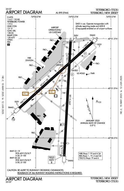
Runway 01/19
Dimensions:
7,000 × 150 ft
(2,134 × 46 m)
(2,134 × 46 m)
Weight Bearing Cap:
Single wheel: 50,000 lbs
Double wheel: 100,000 lbs
Double wheel: 100,000 lbs
Surface:
asphalt, grooved, in good condition
Runway Edge Lights:
High
Comments:
Pcr Value: 459/F/D/X/T
FAA
| Designator: | 01 | 19 |
| Elevation: | 8.4 ft | 6.4 ft |
| Heading: | 015° magnetic 003° true | 195° magnetic 183° true |
| Gradient: | 0.03% down | 0.03% up |
| Traffic Pattern: | Left Pattern | Left Pattern |
| Markings: | precision, in Good condition | precision, in Good condition |
| Approach Lighting: |
|
|
| Displaced Threshold: | 771 ft | 763 ft |
| ILS/LOC: | n/a | ILS/DME |
| Obstructions: | Tree, 524 ft Left ft of center, 88 ft high, 802 ft from end, 7:1 clearance slope | Building, 319 ft Left ft of center, 263 ft high, 9,256 ft from end, 34:1 clearance slope |
| Comments: | Rwy 01 67 Ft Tree District 1200 Ft, 400 Ft Right, 16:1 Based on Dthr. FAA Rwy 01/19 Dthr Cntrln Lgts Out of service Indefly. FAA | Engineered Materials Arresting System (Emas) 355 Ft in Length by 162 Ft Width Lctd At Dep End Rwy 19. FAA Rwy 19 Approach Ratio 25:1 to Dthr. FAA |
Runway 06/24
Dimensions:
6,013 × 150 ft
(1,833 × 46 m)
(1,833 × 46 m)
Weight Bearing Cap:
Single wheel: 50,000 lbs
Double wheel: 100,000 lbs
Double wheel: 100,000 lbs
Surface:
asphalt, grooved, in good condition
Runway Edge Lights:
High
Comments:
Pcr Value: 343/F/D/X/T
FAA
| Designator: | 06 | 24 |
| Elevation: | 4.9 ft | 6.8 ft |
| Heading: | 060° magnetic 048° true | 240° magnetic 228° true |
| Gradient: | 0.03% up | 0.03% down |
| Traffic Pattern: | Left Pattern | Left Pattern |
| Markings: | precision, in Good condition | precision, in Good condition |
| Approach Lighting: |
|
|
| Displaced Threshold: | n/a | n/a |
| ILS/LOC: | ILS/DME | n/a |
| Obstructions: | Tree, 1,293 ft Left ft of center, 148 ft high, 5,950 ft from end, 38:1 clearance slope | Tree, 462 ft Left ft of center, 77 ft high, 1,705 ft from end, 19:1 clearance slope |
| Comments: | Emas Non-Std Arresting Gear/System: Engineered Materials Arresting System (Emas) 250 Ft in Length by 170 Ft Width Lctd At Dep End Rwy 06. FAA | Engineered Materials Arresting System (Emas) 348 Ft in Length by 162 Ft Width Lctd At Dep End Rwy 24. FAA |
TFRs
Location: TEB
Please verify all content below using the FAA TFR Search Site or with a flight briefer.
TFR count: 0
NOTAMs
Location: TEB
Please verify all content below using the FAA NOTAM Search Site or with a flight briefer.
NOTAM count: 65 (Partial list shown. Expand to see full list HERE.)
| Number: | Start Date: (UTC) | End Date: (UTC) | Condition: |
|---|---|---|---|
| 01/427 | 01/25/2025 1708 | TWY J BTN RWY 01/19 AND TWY L CHANGED TO TWY L6 | |
| 01/431 | 01/25/2025 1937 | TWY E CHANGED TO TWY L5 | |
| 03/167 | 04/01/2025 1600 | 04/03/2025 0359 | OBST CRANE (ASN 2024-AEA-13282-OE) 404850N0740435W (2.3NM SSW TEB) 150FT (144FT AGL) FLAGGED AND LGTD |
| 03/155 | 03/25/2025 1210 | NAV ILS RWY 06 NOT MNT | |
| 3/1005 | 08/10/2023 0901 | IAP TETERBORO, TETERBORO, NJ.
RNAV (GPS) X RWY 6, AMDT 3...
CHANGE PLANVIEW NOTE TO READ: PROCEDURE NA FOR A… | |
| 03/158 | 03/26/2025 1337 | 06/15/2025 2359 | SVC AUTOMATED WX BCST SYSTEM NOW 201-473-3130 |
| 04/016 | 04/02/2025 1130 | 04/02/2025 1600 | TWY K LGT U/S |
| 04/009 | 04/02/2025 1130 | 04/02/2025 1600 | TWY Q SIGNS BTN TWY L AND APCH END RWY 24 LGT U/S |
Additional Remarks
Acft & Helicopter Noise Abatement Rules in Eff; CTC Airport Noise Abatement Ofc 201-393-0399/288-1775 for Copy of Procedures & Rules Prior to Arr. Ry 24 Noise Critical Ry Max Noise Limit of 80 Db Between 2200-0700 & 90 Db All Other Hrs.
Source:
FAA
Federal Aviation Administration
Acft Capable of Operating Abv 100,000 Pounds Must Submit Certification to Airport Manager Verifying Aircraft Operating Weight is Less Than 100,000 Lbs. Contact Airport Operations At 201-288-1775 for Forms.
Source:
FAA
Federal Aviation Administration
All Acft Avoid Hospital 1.7 Mile North of Rwy 01/19.
Source:
FAA
Federal Aviation Administration
Clsd to Motorless Acft - Unctld Acft & Ultralight Activity Excep by Prior Permission.
Source:
FAA
Federal Aviation Administration
Deer and Bird Act on and In vicinity of Arpt.
Source:
FAA
Federal Aviation Administration
Dly Cons Const Act All Quadrants.
Source:
FAA
Federal Aviation Administration
Hel Operations Over Residential Areas Blo 1000 Ft MSL Should be Avoided.
Source:
FAA
Federal Aviation Administration
Stage 1 Acft not Permitted to Opr At Teterboro Arpt.
Source:
FAA
Federal Aviation Administration
Teb Rnav (Gps) X Rwy 06 is Prim Rnav Approach to Rwy 06.
Source:
FAA
Federal Aviation Administration
Arff Index B Equipment Coverage Provided.
Source:
FAA
Federal Aviation Administration
Noise Abatement
Instrument Procedures
Data Cycle:
Operations & More Information
Lat/Long:
- 40.85011, -74.06083
- 40° 51′ 0.4″ N, 74° 3′ 39.0″ W
- 40° 51.007′ N, 74° 3.650′ W
ARTCC:
New York (ZNY)
App/Depart Control Facility:
PHL
Chart:
NACO: New York Sectional
FSS:
Millville (MIV)
1-800-WX-BRIEF
1-800-WX-BRIEF
Wind Indicator:
Lighted
Mag Var:
12W (1980)
NOTAM Facility:
Seg Circle:
No
Beacon:
Present
Lighting:
No lighting reported.
Pattern Altitude:
TPA 1500 Ft MSL for Large/Turbine Acft; 1000 Ft MSL for All Others.
FAA
Special Operations:
Communications Card
| Type: | Frequency / Phone: | Sector / Comments: | Call Sign: |
|---|---|---|---|
| Approach | 127.6 | Newark | |
| ASOS | (201) 426-9519 | Teterboro | |
| Clearance Delivery | 128.05 | Teterboro | |
| D-ATIS | 114.2 | Teterboro | |
| D-ATIS | 132.85 | Teterboro | |
| Departure | 119.2 | Newark | |
| Departure | 126.7 | Newark | |
| Emergency | 121.5 | Teterboro | |
| Ground Control | 121.9 | Teterboro | |
| JAIKE STAR | 124.35 | Newark | |
| MAZIE STAR | 119.75 | Newark | |
| MAZIE STAR | 124.55 | Newark | |
| OPS | 130.575 | Teterboro | |
| RAMP CTL | 120.675 | Teterboro | |
| Tower | 119.5 | Teterboro | |
| Tower(S) | 125.1 | Teterboro | |
| VFR ADZY | 119.5 | Teterboro | |
| WILKES-BARRE STAR | 127.6 | Newark |
Navaids
Services
Fuel:
100LL Low-Lead, Jet A
AM
Engine Repair:
Major
AM
Airframe Repair:
Major
AM
Bottled Oxygen:
High/Low
AM
Bulk Oxygen:
High/Low
AM
Customs:
International Landing Rights
AM
Transportation:
Courtesy Transportation, Limousine, Public Transportation, Shuttle Service, Van
AM
Activities:
None Reported
Camping On Field:
None Reported
Aircraft & Activity
Webcams
METARs
TAFs
Contact Addresses
Airport Manager
Sherri Smith
Teterboro, NJ 07608
(201) 807-4019 (Office)
Owner
Port Authority of Ny & Nj
New York, NY 10006
(212) 435-3640 (Office)
Airport Reviews
Overall:
No ratings | 5 reviews
Runways and Taxiways:No ratings
Markings and Signage:No ratings
Ground Transportation:No ratings
Sort By:
- 12/21/15CHASE O.I flew into KTEB on 12/20/2015 so that I could do a quick day trip into the city to see the tree and get into the Christmas spirit. Usually I fly into KHPN, but since this was a quick day trip I decided to fly into KTEB since it is closer to the city…
- 9/9/17IAN B.Sep 9-10, 2017. IRMA will destroy a pilots paradise - the Keys - K MTH etc. For more info 2 sites are being built as we speak - KeysIrma and PilotNoGo. Under construction. Help & Prayers are needed.
- 8/3/17JOHN R.I fly into KTEB a few times a year and although the majority of traffic is business jets, piston GA traffic is treated the same. Controllers are great at mixing in the pistons with jets, however it's important to be prepped for the approaches into TE…
- 7/22/15ERIC B.Forgot to mention: I asked when I called whether Uber was an option to New York. Staff said lots of people, including *passengers* on the big jets, used Uber with no problem. And, it was no problem. Less than 10 minutes for the ride to show up and 30…
- 7/16/13DOUGLAS M.I just want to add my two cents on Meridian. They are every bit as good as all the previous testimonials state. Among a sea of jets, our little C-182 looked out of place. Yet, we were promptly waived into parking, fuel order taken and whisked out of …