FAA Information Effective: May 15, 2025
All information is provided from the FAA unless otherwise noted.
(KMWA) Veterans Airport of Southern Illinois
No ratings | No reviews
Overview
Attendance:
Attended
Year-round, 7 Days a Week,All
FAA
Elevation:
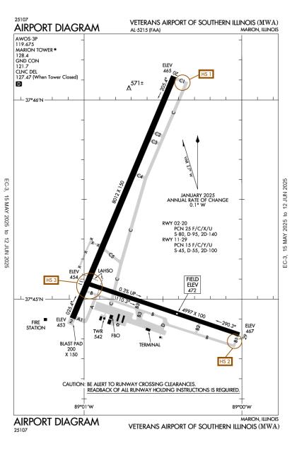
472 ft (Surveyed)
Tower:
Apch/Dep Svc Prvdd By Kansas City Artcc On Freqs 127.475/346.275 (Marion Rcag).
FAA
Emergency Frequency Not Available.
FAA
Kansas City Artcc Prvds Clnc Del On Freq 127.475 When Atct Clsd.
FAA
Tower Hrs: 0700-1900
FAA
Airspace:
CLASS D SVC 0700-1900; OTHER TIMES CLASS G
FAA
Fees:
Timezone:
CDT (UTC-05:00)
Sunrise-Sunset:
5:47 am - 8:00 pm
Evening-Morning Civil Twilight:
8:29 pm
(Today)
(Today)
-
5:17 am
(Tomorrow)
(Tomorrow)
Minimum Fuel Prices:
$5.72
100LL (full)
$4.77
Jet-A-Premix/Prist (full)
Runway
Satellite
Sectional
FBOs
Submit New FBO
Midwest Aviation
No ratings | Be the first to review this business
Services Offered:
Maintenance
Car Rental
$5.72 | 100LL | full
$4.77 | Jet-A-Premix/Prist | full
Location:
On field: S
Phone:
(618) 993-2764
Freq. Monitored:
UNICOM: 122.95
Fees:
Ramp, Other
Flight Training
Submit New Flight School
Other businesses
Submit New Business
AOPA Travel Discounts 
FlightBridge is the ultimate all-in-one travel booking platform built for the general aviation community. AOPA Members receive free access to FlightBridge with AOPA discounted rates automatically applied. Members save an average of 30% on hotel bookings! Learn more about FlightBridge HERE.
Local Food/Lodging/Activities
Local Attractions
Local Activities
Restaurants
Hotels and Lodging
Travel Discounts
Southern Illinois University
Crab Orchard Wildlife Preserve
Giant City State Park
Cracker Barrell
(618) 993-6306
Bob Evans
(618) 993-1487
T-Bird
(618) 998-0501
Marion Cab
993-8181
MWA
Southern Illinois University
Crab Orchard Wildlife Preserve
Giant City State Park
Cracker Barrell
Bob Evans
T-Bird
Marion Cab
Flying Clubs
Submit New Flying Club
Runway 02/20
Dimensions:
8,012 × 150 ft
(2,442 × 46 m)
(2,442 × 46 m)
Weight Bearing Cap:
Single wheel: 80,000 lbs
Double wheel: 95,000 lbs
Double tandem: 140,000 lbs
Double wheel: 95,000 lbs
Double tandem: 140,000 lbs
Surface:
asphalt, porous friction course, in good condition
Runway Edge Lights:
High
Comments:
n/a
| Designator: | 02 | 20 |
| Elevation: | 452.6 ft | 465.4 ft |
| Heading: | 021° magnetic 022° true | 201° magnetic 202° true |
| Gradient: | 0.16% up | 0.16% down |
| Traffic Pattern: | Left Pattern | Left Pattern |
| Markings: | precision, in Fair condition | precision, in Fair condition |
| Approach Lighting: |
|
|
| Displaced Threshold: | n/a | n/a |
| ILS/LOC: | n/a | ILS |
| Obstructions: | Trees, 697 ft Left ft of center, 56 ft high, 2,130 ft from end, 34:1 clearance slope | Tree, 847 ft Left ft of center, 83 ft high, 2,945 ft from end, 33:1 clearance slope |
| Comments: | n/a | n/a |
Runway 11/29
Dimensions:
4,997 × 100 ft
(1,523 × 30 m)
(1,523 × 30 m)
Weight Bearing Cap:
Single wheel: 45,000 lbs
Double wheel: 55,000 lbs
Double tandem: 100,000 lbs
Double wheel: 55,000 lbs
Double tandem: 100,000 lbs
Surface:
asphalt, concrete, grooved, in excellent condition
Runway Edge Lights:
Medium
Comments:
First 1200 Ft of Rwy 29 Grvd Conc.
FAA
| Designator: | 11 | 29 |
| Elevation: | 453.7 ft | 467.2 ft |
| Heading: | 107° magnetic 108° true | 287° magnetic 288° true |
| Gradient: | 0.27% up | 0.27% down |
| Traffic Pattern: | Left Pattern | Left Pattern |
| Markings: | basic, in Fair condition | basic, in Fair condition |
| Approach Lighting: |
|
|
| Displaced Threshold: | n/a | n/a |
| ILS/LOC: | n/a | n/a |
| Obstructions: | Tree, 90 ft Left ft of center, 62 ft high, 1,537 ft from end, 21:1 clearance slope | Sign, 249 ft Left ft of center, 30 ft high, 1,218 ft from end, 33:1 clearance slope |
| Comments: | n/a | n/a |
TFRs
Location: MWA
Please verify all content below using the FAA TFR Search Site or with a flight briefer.
TFR count: 0
NOTAMs
Location: MWA
Please verify all content below using the FAA NOTAM Search Site or with a flight briefer.
NOTAM count: 11 (Partial list shown. Expand to see full list HERE.)
| Number: | Start Date: (UTC) | End Date: (UTC) | Condition: |
|---|---|---|---|
| 05/008 | 05/06/2025 1136 | 05/16/2025 2300 | RWY 20 6000FT DIST REMAINING SIGN S SIDE LGT U/S |
| 05/015 | 05/14/2025 1738 | 09/11/2025 1738 | OBST TOWER LGT (ASR 1263458) 373355.00N0884635.10W (15.9NM SE MWA) 946.9FT (255.9FT AGL) U/S |
| 05/002 | 05/01/2025 1900 | 06/01/2025 2359 | OBST TOWER LGT (ASR 1047010) 373650.00N0885220.00W (10.7NM SE MWA) 1637.5FT (1037.4FT AGL) U/S |
| 12/017 | 12/19/2024 1629 | 06/30/2025 2200 | RWY 11 RWY END ID LGT U/S |
| 03/005 | 03/06/2025 1419 | 07/04/2025 1419 | OBST TOWER LGT (ASR 1291796) 372530.90N0890852.10W (20.9NM SSW MWA) 870.4FT (267.7FT AGL) U/S |
| 12/015 | 12/19/2024 1628 | 06/30/2025 2200 | RWY 02 RWY END ID LGT U/S |
| 05/016 | 05/14/2025 2104 | OBST POLE (ASN UNKNOWN) 374508N0890044W (.2NM SE MWA) 497FT (25FT AGL) NOT LGTD | |
| 04/005 | 04/11/2025 1641 | 07/11/2025 0400 | OBST TOWER LGT (ASR 1236884) 375109.30N0885607.40W (6.9NM NNE MWA) 767.1FT (310.0FT AGL) U/S |
Additional Remarks
Helipads are Located in the Northeast Corner of Ga Ramp. Helipads are in Non-Movement Area.
Source:
FAA
Federal Aviation Administration
Twy E & E4 Clsd Indef.
Source:
FAA
Federal Aviation Administration
Waterfowl & Deer on & In vicinity of Arpt.
Source:
FAA
Federal Aviation Administration
72 Hr Prior Permission Required Rqr for Unsked Acr Operations with More Than 30 Pax Seats - CTC Amgr.
Source:
FAA
Federal Aviation Administration
Noise Abatement
Instrument Procedures
Data Cycle:
Operations & More Information
Lat/Long:
- 37.75497, -89.01108
- 37° 45′ 17.9″ N, 89° 0′ 39.9″ W
- 37° 45.298′ N, 89° 0.665′ W
ARTCC:
Kansas City (ZKC)
App/Depart Control Facility:
Unknown
Chart:
NACO: St Louis Sectional
FSS:
Saint Louis (STL)
1-800-WX-BRIEF
1-800-WX-BRIEF
Wind Indicator:
Lighted
Mag Var:
01E (1985)
NOTAM Facility:
Seg Circle:
Yes
Beacon:
Present
Lighting:
Pilot Activated Lighting:
- medium intensity: 5 clicks in 5 secs
- high intensity: 7 clicks in 5 secs
AM
Actvt MALSR Rwy 20; REIL Rwy 11 & 29; PAPI Rwy 02, 11 & 29; HIRL Rwy 02/20; MIRL Rwy 11/29 - CTAF. HIRL Rwy 02/20 Preset to Low Intst; Incr Intst - CTAF.
FAA
Pattern Altitude:
Light Aircraft 1271 MSL
Heavy Aircraft 1971 MSL
AM
Special Operations:
Communications Card
| Type: | Frequency / Phone: | Sector / Comments: | Call Sign: |
|---|---|---|---|
| AWOS-3P | 119.675T (618) 942-8877 | Marion | |
| CTAF | 128.4 | Marion | |
| Ground Control | 121.7 | Marion | |
| Tower | 128.4 | Marion | |
| UNICOM | 122.95 | Marion |
Navaids
Services
Fuel:
100LL Low-Lead, Jet A
AM
Engine Repair:
Major
AM
Airframe Repair:
Major
AM
Bottled Oxygen:
None
Bulk Oxygen:
None
Customs:
None
Transportation:
Courtesy Transportation
AM
Activities:
None Reported
Camping On Field:
None Reported
Aircraft & Activity
Webcams
METARs
TAFs
Contact Addresses
Airport Manager
Douglas S Kimmel
Marion, IL 62959
(618) 993-3353 (Office)
Owner
Williamson County Airport Authority
Marion, IL 62959
(618) 993-3353 (Office)
Remarks:
Email Address: Airport1@Midwest.Net (All Lower Case)
FAA
M-F 1500-2300Z 618-993-3353; Aft Hr- 618-889-3900.
FAA