FAA Information Effective: May 15, 2025
All information is provided from the FAA unless otherwise noted.
(KPLR) St Clair County Airport
2 ratings | 3 reviews
Overview
Attendance:
Attended
Year-round,Mon-Sat/0730-1700
FAA
Year-round,Sun/Unattended
FAA
Runways:
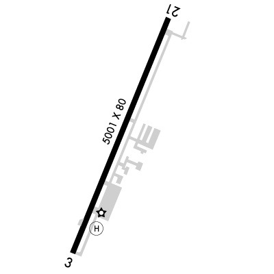
03/21
Runway length: 5,001 ft (1,524 m)
Elevation:
485 ft (Surveyed)
Tower:
No
Airspace:
Unknown
Fees:
Landing, Ramp, Tie Down, Other
Click FBO link(s) below for details:
Click FBO link(s) below for details:
FBO Fee Details:
St. Clair County Airport AuthorityTimezone:
CDT (UTC-05:00)
Sunrise-Sunset:
5:42 am - 7:43 pm
Evening-Morning Civil Twilight:
8:11 pm
(Today)
(Today)
-
5:14 am
(Tomorrow)
(Tomorrow)
Minimum Fuel Prices:
$5.30
100LL (full)
$5.00
100LL (self)
$5.10
Jet-A-Premix/Prist (full)
Runway
Satellite
Sectional
FBOs
Submit New FBO
St. Clair County Airport Authority
No ratings | Be the first to review this business
Services Offered:
Car Rental
$5.30 | 100LL | full
$5.00 | 100LL | self
$5.10 | Jet-A-Premix/Prist | full
Location:
On field: S
Phone:
(205) 338-9456
Freq. Monitored:
UNICOM: 123.05
Fees:
Landing, Ramp, Tie Down, Other
Flight Training
Submit New Flight School
Other businesses
Submit New Business
AOPA Travel Discounts 
FlightBridge is the ultimate all-in-one travel booking platform built for the general aviation community. AOPA Members receive free access to FlightBridge with AOPA discounted rates automatically applied. Members save an average of 30% on hotel bookings! Learn more about FlightBridge HERE.
Local Food/Lodging/Activities
Local Attractions
Local Activities
Restaurants
Hotels and Lodging
Travel Discounts
(205) 338-1540
Knox Landing Campgrounds
(205) 338-3403
Great Wall Chinese
(205) 338-8908
Kickers Sports Grill
(205) 338-0481
Big Daddy's
(205) 884-1070
PLR
Motor Sports Hall of Fame
Talladega Super Speedway
Pell City Recreation Hall
Knox Landing Campgrounds
Great Wall Chinese
Kickers Sports Grill
Big Daddy's
Flying Clubs
Submit New Flying Club
Runway 03/21
Dimensions:
5,001 × 80 ft
(1,524 × 24 m)
(1,524 × 24 m)
Weight Bearing Cap:
Single wheel: 30,000 lbs
Surface:
asphalt, no surface treatment, in fair condition
Runway Edge Lights:
Medium
Comments:
n/a
| Designator: | 03 | 21 |
| Elevation: | 483.2 ft | 482.4 ft |
| Heading: | 026° magnetic 022° true | 206° magnetic 202° true |
| Gradient: | 0.02% down | 0.02% up |
| Traffic Pattern: | Left Pattern | Left Pattern |
| Markings: | non-precision, in Good condition | non-precision, in Good condition |
| Approach Lighting: |
|
|
| Displaced Threshold: | 230 ft | n/a |
| ILS/LOC: | n/a | n/a |
| Obstructions: | Tree, 338 ft Right ft of center, 88 ft high, 968 ft from end, 8:1 clearance slope | Tree, 257 ft Right ft of center, 35 ft high, 504 ft from end, 8:1 clearance slope |
| Comments: | Rwy 03 Approach Ratio 24:1 to Dsplcd Thld. FAA | n/a |
TFRs
Location: PLR
Please verify all content below using the FAA TFR Search Site or with a flight briefer.
TFR count: 0
NOTAMs
Location: PLR
Please verify all content below using the FAA NOTAM Search Site or with a flight briefer.
NOTAM count: 5
| Number: | Start Date: (UTC) | End Date: (UTC) | Condition: |
|---|---|---|---|
| 03/952 | 03/29/2025 0350 | 08/29/2025 2359 | OBST TOWER LGT (ASR 1033525) 333624.00N0862503.00W (8.9NM WNW PLR) 2045.9FT (565.9FT AGL) U/S |
| 04/839 | 04/29/2025 0124 | 06/13/2025 0124 | OBST TOWER LGT (ASR 1306478) 332906.19N0861612.41W (4.6NM SSW PLR) 892FT (265FT AGL) U/S |
| 05/502 | 05/16/2025 0420 | 09/13/2025 0420 | OBST TOWER LGT (ASR 1063779) 333110.50N0861811.80W (3.6NM SW PLR) 741.8FT (253.9FT AGL) U/S |
| 05/586 | 05/18/2025 1225 | 08/16/2025 0400 | OBST TOWER LGT (ASR 1011202) 333528.90N0862218.20W (6.4NM WNW PLR) 998.0FT (257.9FT AGL) U/S |
| 04/682 | 04/23/2025 1017 | 08/21/2025 1017 | OBST TOWER LGT (ASR 1291667) 333801.60N0862037.00W (6.5NM NW PLR) 1016.1FT (258.2FT AGL) U/S |
Additional Remarks
Gco Avbl on Freq 121.725 (Bhm Clnc Del).
Source:
FAA
Federal Aviation Administration
Noise Abatement
Instrument Procedures
Data Cycle:
Operations & More Information
Lat/Long:
- 33.55883, -86.24906
- 33° 33′ 31.8″ N, 86° 14′ 56.6″ W
- 33° 33.530′ N, 86° 14.943′ W
ARTCC:
Atlanta (ZTL)
App/Depart Control Facility:
BHM
Chart:
NACO: Atlanta Sectional
FSS:
Anniston (ANB)
1-800-WX-BRIEF
1-800-WX-BRIEF
Wind Indicator:
Lighted
Mag Var:
04W (2020)
NOTAM Facility:
Seg Circle:
No
Beacon:
Present
Lighting:
Actvt PAPI Rwy 03 & 21; MIRL Rwy 03/21 - CTAF.
FAA
Pattern Altitude:
No data provided. Assume 1000 AGL.
Special Operations:
Communications Card
| Type: | Frequency / Phone: | Sector / Comments: | Call Sign: |
|---|---|---|---|
| Approach/Departure | 123.8 | Birmingham | |
| AWOS-3P | 119.625T (205) 884-4359 | ||
| Clearance Delivery | 121.725 | Birmingham | |
| CTAF | 123.05 | ||
| UNICOM | 123.05 |
Navaids
Services
Fuel:
100LL Low-Lead
AM
Engine Repair:
Major
AM
Airframe Repair:
Major
AM
Bottled Oxygen:
None
Bulk Oxygen:
None
Customs:
None
Transportation:
Courtesy Transportation
AM
Activities:
Intensive Flight Training
AM
Camping On Field:
None Reported
Aircraft & Activity
Webcams
METARs
METARs from this airport:
METARs from nearby reporting stations:
TAFs
TAFs from nearby airports:
KASN TAF
10 nm E
Issued:
11:20 AM GMT
(3 hours ago)
Today 12:00 PM - 3:00 PM GMT
Today 3:00 PM - Tomorrow 3:00 AM GMT
Vis:
6+
SM
Wind:
@
10
KT
Cld:
- Scattered clouds 3500' AGL
Wx:
N/A
Tomorrow 12:00 AM - 3:00 AM GMT
PROB30
Vis:
4
SM
Wind:
Cld:
- Broken clouds 10000' AGL
Wx:
Thunderstorm, Rain, Mist
Tomorrow 3:00 AM - 6:00 AM GMT
Vis:
6
SM
Wind:
@
5
KT
Cld:
- Broken clouds 9000' AGL
Wx:
Rainshowers, Mist
Tomorrow 3:00 AM - 6:00 AM GMT
PROB30
Vis:
4
SM
Wind:
Cld:
- Overcast 2500' AGL
Wx:
Thunderstorm, Rain, Mist
Tomorrow 6:00 AM - 11:00 AM GMT
Tomorrow 6:00 AM - 9:00 AM GMT
PROB30
Vis:
4
SM
Wind:
Cld:
- Overcast 2500' AGL
Wx:
Thunderstorm, Rain, Mist
Tomorrow 11:00 AM - 12:00 PM GMT
KANB TAF
20 nm E
Issued:
11:20 AM GMT
(3 hours ago)
Today 12:00 PM - 3:00 PM GMT
Today 3:00 PM - Tomorrow 3:00 AM GMT
Tomorrow 12:00 AM - 3:00 AM GMT
PROB30
Vis:
4
SM
Wind:
Cld:
- Broken clouds 10000' AGL
Wx:
Thunderstorm, Rain, Mist
Tomorrow 3:00 AM - 6:00 AM GMT
Vis:
6
SM
Wind:
@
6
KT
Cld:
- Broken clouds 9000' AGL
Wx:
Rainshowers, Mist
Tomorrow 3:00 AM - 6:00 AM GMT
PROB30
Vis:
4
SM
Wind:
Cld:
- Overcast 2500' AGL
Wx:
Thunderstorm, Rain, Mist
Tomorrow 6:00 AM - 11:00 AM GMT
Tomorrow 6:00 AM - 9:00 AM GMT
PROB30
Vis:
4
SM
Wind:
Cld:
- Overcast 2500' AGL
Wx:
Thunderstorm, Rain, Mist
Tomorrow 11:00 AM - 12:00 PM GMT
KBHM TAF
25 nm W
Issued:
11:20 AM GMT
(3 hours ago)
Today 12:00 PM - 3:00 PM GMT
Today 3:00 PM - 7:00 PM GMT
Vis:
6+
SM
Wind:
@
8
KT
Cld:
- Scattered clouds 3500' AGL
Wx:
N/A
Today 7:00 PM - Tomorrow 12:00 AM GMT
Vis:
6+
SM
Wind:
@
12
G
22
KT
Cld:
- Scattered clouds 9000' AGL
Wx:
N/A
Today 9:00 PM - Tomorrow 12:00 AM GMT
PROB30
Vis:
4
SM
Wind:
Cld:
- Broken clouds 10000' AGL
Wx:
Thunderstorm, Rain, Mist
Tomorrow 12:00 AM - 6:00 AM GMT
Vis:
6
SM
Wind:
@
9
KT
Cld:
- Scattered clouds 9000' AGL
Wx:
Rainshowers, Mist
Tomorrow 12:00 AM - 6:00 AM GMT
PROB30
Vis:
4
SM
Wind:
Cld:
- Broken clouds 9000' AGL
Wx:
Thunderstorm, Rain, Mist
Tomorrow 6:00 AM - 12:00 PM GMT
KEET TAF
35 nm SW
Issued:
11:20 AM GMT
(3 hours ago)
Today 12:00 PM - 3:00 PM GMT
Today 3:00 PM - Tomorrow 12:00 AM GMT
Vis:
6+
SM
Wind:
@
7
KT
Cld:
- Scattered clouds 3500' AGL
Wx:
N/A
Tomorrow 12:00 AM - 3:00 AM GMT
Vis:
6+
SM
Wind:
@
6
KT
Cld:
- Scattered clouds 10000' AGL
Wx:
N/A
Tomorrow 12:00 AM - 3:00 AM GMT
PROB30
Vis:
4
SM
Wind:
Cld:
- Broken clouds 10000' AGL
Wx:
Thunderstorm, Rain, Mist
Tomorrow 3:00 AM - 6:00 AM GMT
Vis:
6
SM
Wind:
@
5
KT
Cld:
- Broken clouds 9000' AGL
Wx:
Rainshowers, Mist
Tomorrow 3:00 AM - 6:00 AM GMT
PROB30
Vis:
4
SM
Wind:
Cld:
- Overcast 2500' AGL
Wx:
Thunderstorm, Rain, Mist
Tomorrow 6:00 AM - 12:00 PM GMT
Contact Addresses
Airport Manager
Wendy Watson
Pell City, AL 35128
(205) 338-9456 (Office)
Owner
St Clair County Airport Authority
Pell City, AL 35128
(205) 338-9456 (Office)
Remarks:
Contact Person: Erskine Funderburg; Chairman St. Clair County Airport Authority.
FAA
Airport Reviews
Overall:
2 ratings | 3 reviews
Runways and Taxiways:No ratings
Markings and Signage:No ratings
Ground Transportation:No ratings
Sort By:
- 8/28/18Forest K.Great airport. Nice scenery, no Class C to worry about, and plenty of parking. Better gas prices than BHM! And you can ask to borrow 1 of 2 crew cars to grab a bite to eat. If you have time, take a 15 minute drive to Barber Motorsports Motorcycl…
- 5/22/14BRAD F.We stopped in for some fuel on the trip back from the beach when some unexpected fog moved in. We were unable to leave. It was about 5:00pm and closing time for the FBO. The guys were extremely accomodating, offering to leave the FBO open until we ma…
- 4/25/19JOHN W.Very friendly and accommodating FBO staff. Runway in excellent condition, adequate ramp space w/self-service 100LL. Easy traffic flow if you are looking for a quick refuel in between B-ham and Atlanta. Highly Recommend.
Nearby Events
- aopa rusty pilotsAOPA Rusty Pilots Seminar at Tuscaloosa National Airport (TCL)07/12/2025Location: Tuscaloosa National Airport (TCL)
 Description:Life may have gotten in the way, but the dream of flight can be yours again. Returning to the skies is not as difficult as most rusty pilots think.
 - airshow
 Description:The North Alabama Airfest is an aviation event held at the Pryor Field Regional Airport (DCU), bringing together aviation enthusiasts, families, and thrill-seekers for a weekend of high-flying fun!
 - airshow with military demonstration team
 Description:The Air Dot Show tours soars into Atlanta ~ October 11 -12, 2025
 - airshow with military demonstration team
 Description:Wings Over North Georgia Air Show