FAA Information Effective: Apr 17, 2025
All information is provided from the FAA unless otherwise noted.
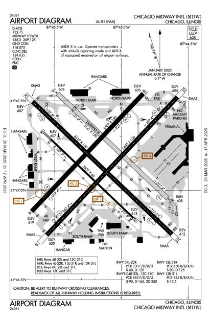
(KMDW) Chicago Midway International Airport
Overview
Attended
Click FBO link(s) below for details:
Signature Flight Support
(Today)
(Tomorrow)
FBOs
AOPA Travel Discounts 
Local Food/Lodging/Activities
Flying Clubs
Runway 13C/31C
(1,988 × 46 m)
Double wheel: 165,000 lbs
Double tandem: 250,000 lbs
| Designator: | 13C | 31C |
| Elevation: | 607 ft | 611.6 ft |
| Heading: | 138° magnetic 134° true | 318° magnetic 314° true |
| Gradient: | 0.07% up | 0.07% down |
| Traffic Pattern: | Left Pattern | Left Pattern |
| Markings: | precision, in Good condition | precision, in Good condition |
| Approach Lighting: |
|
|
| Displaced Threshold: | 463 ft | 696 ft |
| ILS/LOC: | ILS/DME | ILS/DME |
| Obstructions: | Road, 225 ft Right ft of center, 15 ft high, 200 ft from end | Road, 225 ft Left ft of center, 47 ft high, 200 ft from end |
| Comments: | Engineered Materials Arresting System (Emas) 190 Ft in Length by 170 Ft in Width Lctd At the Der 13C. FAA Rwy 13C Approach Ratio 16:1 At Dsplcd Thld. Tree 453 Ft R 915 Ft from Dsplcd Thld. FAA | Engineered Materials Arresting System (Emas) 210 Ft in Length by 170 Ft in Width Lctd At the Der 31C. FAA Rwy 31C Approach Ratio 24:1 At Dsplcd Thr. Tree 1211 Ft from Dsplcd Thr 459 Ft R. FAA |
Runway 04R/22L
(1,964 × 46 m)
Double wheel: 165,000 lbs
Double tandem: 250,000 lbs
| Designator: | 04R | 22L |
| Elevation: | 619.7 ft | 605.2 ft |
| Heading: | 047° magnetic 043° true | 227° magnetic 223° true |
| Gradient: | 0.22% down | 0.22% up |
| Traffic Pattern: | Left Pattern | Left Pattern |
| Markings: | precision, in Good condition | precision, in Good condition |
| Approach Lighting: |
|
|
| Displaced Threshold: | 518 ft | 635 ft |
| ILS/LOC: | ILS/DME | n/a |
| Obstructions: | Road, 325 ft Right ft of center, 15 ft high, 200 ft from end | Road, 350 ft Left ft of center, 15 ft high, 200 ft from end |
| Comments: | Engineered Materials Arresting System (Emas) 249 Ft in Length by 170 Ft in Width Lctd At the Der 04R. FAA Rwy 04R Approach Ratio 16:1 At Dsplcd Thld. Tree 547 Ft R 1122 Ft from Dsplcd Thld. FAA | Engineered Materials Arresting System (Emas) 346 Ft in Length by 170 Ft in Width Lctd At the Der 22L. FAA Rwy 22L Approach Ratio 19:1 At Dsplcd Thld. Lgt Pole 474 Ft R 674 Ft from Dsplcd Thld. FAA |
Runway 04L/22R
(1,679 × 46 m)
Double wheel: 120,000 lbs
| Designator: | 04L | 22R |
| Elevation: | 618.5 ft | 605.2 ft |
| Heading: | 047° magnetic 043° true | 227° magnetic 223° true |
| Gradient: | 0.24% down | 0.24% up |
| Traffic Pattern: | Left Pattern | Left Pattern |
| Markings: | non-precision, in Good condition | non-precision, in Good condition |
| Approach Lighting: |
|
|
| Displaced Threshold: | 758 ft | 878 ft |
| ILS/LOC: | n/a | n/a |
| Obstructions: | Road, 25 ft Left ft of center, 15 ft high, 200 ft from end | Road, 125 ft Right ft of center, 15 ft high, 200 ft from end |
| Comments: | Rwy 04L Approach Ratio 19:1 At Dsplcd Thld. Trees 178 Ft L 1313 Ft from Dsplcd Thld. FAA | Rwy 22R Approach Ratio 37:1 At Dsplcd Thr. Tree 2490 Ft from Dsplcd Thr 319 Ft L. FAA |
Runway 13L/31R
(1,567 × 46 m)
Double wheel: 125,000 lbs
| Designator: | 13L | 31R |
| Elevation: | 606.1 ft | 608.3 ft |
| Heading: | 138° magnetic 134° true | 318° magnetic 314° true |
| Gradient: | 0.04% up | 0.04% down |
| Traffic Pattern: | Left Pattern | Left Pattern |
| Markings: | non-precision, in Good condition | non-precision, in Good condition |
| Approach Lighting: | n/a |
|
| Displaced Threshold: | 752 ft | n/a |
| ILS/LOC: | n/a | n/a |
| Obstructions: | Road, Both-Sides, 15 ft high, 200 ft from end | Pole, 285 ft Right ft of center, 34 ft high, 656 ft from end, 13:1 clearance slope |
| Comments: | n/a | n/a |
Runway 13R/31L
(1,176 × 18 m)
| Designator: | 13R | 31L |
| Elevation: | 606.9 ft | 612.9 ft |
| Heading: | 138° magnetic 134° true | 318° magnetic 314° true |
| Gradient: | 0.16% up | 0.16% down |
| Traffic Pattern: | Not provided. Assume LEFT traffic pattern | Not provided. Assume LEFT traffic pattern |
| Markings: | basic, in Good condition | basic, in Good condition |
| Approach Lighting: | n/a | n/a |
| Displaced Threshold: | n/a | n/a |
| ILS/LOC: | n/a | n/a |
| Obstructions: | Tree, 214 ft Right ft of center, 55 ft high, 1,504 ft from end, 23:1 clearance slope | Tree, 147 ft Right ft of center, 59 ft high, 1,737 ft from end, 26:1 clearance slope |
| Comments: | n/a | n/a |
TFRs
NOTAMs
| Number: | Start Date: (UTC) | End Date: (UTC) | Condition: |
|---|---|---|---|
| 04/242 | 04/24/2025 1329 | 05/31/2025 1100 | TWY Y2 HLDG PSN MARKINGS FOR RWY 04R/22L OBSC |
| 03/422 | 03/28/2025 0526 | 05/12/2025 0721 | OBST POWER LINE LGT (ASN 2017-AGL-1185-OE) 414539N0874321W (2.0NM SE MDW) 719FT (101FT AGL) U/S |
| 04/035 | 04/04/2025 0507 | 05/19/2025 0837 | OBST TOWER LGT (ASN 2017-AGL-1193-OE) 414550N0874411W (1.5NM SSE MDW) 703FT (86FT AGL) U/S |
| 04/251 | 04/25/2025 0237 | 06/08/2025 2359 | OBST POLE LGT (ASN 2017-AGL-1191-OE) 414546N0874356W (1.7NM SSE MDW) 703FT (85FT AGL) U/S |
| 01/625 | 01/23/2025 1959 | 12/31/2025 1200 | RWY 13L/31R CLSD |
| 03/445 | 03/30/2025 0038 | 05/14/2025 0500 | OBST STACK LGT (ASN 2017-AGL-1200-OE) 414551N0874448W (1.3NM S MDW) 702FT (87FT AGL) U/S |
| 5/2354 | 04/04/2025 1505 | IAP CHICAGO MIDWAY INTL, CHICAGO, IL.
RNAV (GPS) RWY 22R, AMDT 1...
DELETE NOTE: CIRCLING TO RWY 31R NA AT N… | |
| 04/273 | 04/27/2025 2050 | 05/26/2025 1800 | TWY F SFC PAINTED HLDG PSN SIGNS AT RWY 13C/31C FADED |
Additional Remarks
Noise Abatement
Instrument Procedures
Operations & More Information
- 41.78597, -87.75242
- 41° 47′ 9.5″ N, 87° 45′ 8.7″ W
- 41° 47.158′ N, 87° 45.145′ W
1-800-WX-BRIEF
Communications Card
| Type: | Frequency / Phone: | Sector / Comments: | Call Sign: |
|---|---|---|---|
| Approach(S) Departure(S) | 126.05 | Chicago | |
| Approach/Departure | 128.2 | Chicago | |
| ASOS | (773) 884-4424 | Midway | |
| CLASS C | 119.45 | Midway | |
| CLASS C(S) | 135.2 | Midway | |
| Clearance Delivery | 124.625 | Midway | |
| D-ATIS | 132.75 | Midway | |
| Emergency | 121.5 | Midway | |
| Ground Control | 118.075 | Midway | |
| Tower | 135.2 | Midway | |
| UNICOM | 122.95 | Midway |
Navaids
Services
Aircraft & Activity
Webcams
METARs
TAFs
Contact Addresses
Airport Manager
Chicago, IL 60666
Owner
Chicago, IL 60638
Airport Reviews
- 10/19/21Don't let the size scare you away.Douglas C.Yes, this is a very busy airport, however, all the controllers and pilots are top notch. There are no student pilots or flight schools here, which makes for a more predictable flow of traffic. Try to avoid the morning and evening rush in order to m…
- 9/28/16MICHAEL Y.Things have changed at Atlantic since these reviews - we arrived in an SR22 and were waved off by a ramper to find a spot to park on the south side of the facility. No meet & greet, we were left to carry our own bags across the apron, no offers to he…
- 10/11/15PETER N.Landed at MDW last week in my Cessna Cardinal, It was IFR & we were all lined up down ILS 4R. In spite of me slowing everybody down, ATC was very patient with me which I really appreciated. Atlantic Aviation are top notch & were very courteous & help…
- 10/29/14WILLIAM O.Air traffic controllers were very professional and accommodating, Atlantic gave is a ride to the L. $7.50 landing, $15 security, $40 first night stay but waived if 15 gal gas purtached at >$8.65/gal, $$20 each additional day., expensive but very nice…
- 10/18/13CHARLES T.Flew into Midway last Thursday and the staff at Atlantic were great. They called a cab and we were on our way downtown in less than 15 minutes (25 minute ride, $40). It was a blue bird day but approach still had me follow the ILS for 31C and then - a…