FAA Information Effective: May 15, 2025
All information is provided from the FAA unless otherwise noted.
(KINW) Winslow-Lindbergh Regional Airport
3 ratings | 7 reviews
Overview
Attendance:
Attended
Year-round,Mon-Fri/0700-1800
FAA
Year-round,Sat-Sun/0800-1700
FAA
Elevation:
4,941 ft (Surveyed)
Tower:
No
Airspace:
CLASS E SVC 0400-2300; OTHER TIMES CLASS G
FAA
Fees:
Timezone:
MST (UTC-07:00)
Sunrise-Sunset:
5:13 am - 7:29 pm
Evening-Morning Civil Twilight:
7:58 pm
(Today)
(Today)
-
4:43 am
(Tomorrow)
(Tomorrow)
Minimum Fuel Prices:
$5.99
100LL (full)
$4.97
100LL (self)
$5.17
Jet-A (full)
$4.29
Jet-A (self)
$5.22
Jet-A-Premix/Prist (full)
Runway
Satellite
Sectional
FBOs
Submit New FBO
Wiseman Aviation
No ratings | Be the first to review this business
Services Offered:
Car Rental
$5.99 | 100LL | full
$4.97 | 100LL | self
$5.17 | Jet-A | full
$4.29 | Jet-A | self
$5.22 | Jet-A-Premix/Prist | full
Location:
On field: NE
Phone:
(928) 289-0100
Freq. Monitored:
UNICOM: 122.8
Fees:
Hangar, Ramp, Other
Flight Training
Submit New Flight School
Other businesses
Submit New Business
AOPA Travel Discounts 
FlightBridge is the ultimate all-in-one travel booking platform built for the general aviation community. AOPA Members receive free access to FlightBridge with AOPA discounted rates automatically applied. Members save an average of 30% on hotel bookings! Learn more about FlightBridge HERE.
Local Food/Lodging/Activities
Local Attractions
Local Activities
Restaurants
Hotels and Lodging
Travel Discounts
Brown Mug Cafe
(928) 289-9973
(928) 289-2515
China Feast
(928) 289-9478
Casa Blanca Cafe
(928) 289-4191
(928) 289-2888
Bojo's Grill & Sports Club
(928) 289-0616
INW
Homolovi Ruins
Old Trails Museum
Winslow Amtrak
Brown Mug Cafe
Church's Chicken
China Feast
Casa Blanca Cafe
Turquoise Room
Bojo's Grill & Sports Club
Flying Clubs
Submit New Flying Club
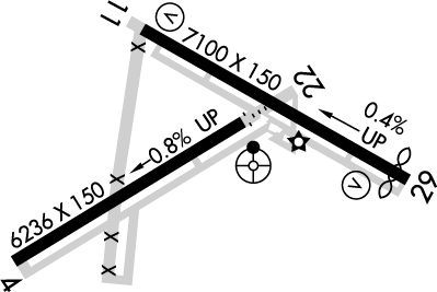
Runway 04/22
Dimensions:
7,499 × 150 ft
(2,286 × 46 m)
(2,286 × 46 m)
Weight Bearing Cap:
Single wheel: 50,000 lbs
Double wheel: 80,000 lbs
Double tandem: 125,000 lbs
Double wheel: 80,000 lbs
Double tandem: 125,000 lbs
Surface:
asphalt, no surface treatment, in good condition
Runway Edge Lights:
Medium
Comments:
n/a
| Designator: | 04 | 22 |
| Elevation: | 4,941.1 ft | 4,881.1 ft |
| Heading: | 045° magnetic 059° true | 225° magnetic 239° true |
| Gradient: | 0.8% down | 0.8% up |
| Traffic Pattern: | Left Pattern | Left Pattern |
| Markings: | non-precision, in Fair condition | non-precision, in Fair condition |
| Approach Lighting: | n/a |
|
| Displaced Threshold: | n/a | 1,262 ft |
| ILS/LOC: | n/a | n/a |
| Obstructions: | n/a | Tree, Both-Sides, 18 ft high, 219 ft from end, 1:1 clearance slope |
| Comments: | n/a | 15 Ft Ditch 15 Ft Fm Rwy End Acrs Thr. +12 Ft Trees 10 Ft Fm Thr 80 Ft L of Cntrln. FAA Apch Ratio, 50:1 to Dthr. FAA |
Runway 11/29
Dimensions:
7,100 × 150 ft
(2,164 × 46 m)
(2,164 × 46 m)
Weight Bearing Cap:
Single wheel: 60,000 lbs
Double wheel: 70,000 lbs
Double tandem: 110,000 lbs
Double wheel: 70,000 lbs
Double tandem: 110,000 lbs
Surface:
asphalt, no surface treatment, in fair condition
Runway Edge Lights:
Medium
Comments:
Edges Both Sides Rough with Cracks & Vegetation; Center Ptn Has Lrg Cracks & 4 in Holes.
FAA
| Designator: | 11 | 29 |
| Elevation: | 4,899.3 ft | 4,870 ft |
| Heading: | 106° magnetic 120° true | 286° magnetic 300° true |
| Gradient: | 0.41% down | 0.41% up |
| Traffic Pattern: | Right Pattern | Left Pattern |
| Markings: | non-precision, in Poor condition | non-precision, in Poor condition |
| Approach Lighting: |
|
|
| Displaced Threshold: | n/a | 344 ft |
| ILS/LOC: | n/a | n/a |
| Obstructions: | n/a | Fence, 75 ft Right ft of center, 8 ft high, 201 ft from end |
| Comments: | +4 Ft Brush 0-200 Ft Fm Thr 75-250 Ft L & R of Cntrln. FAA Faded. FAA | 8 Ft Fence 200 Ft Fm Rwy End Acrs Thr. 3 Ft Brush 0-200 Ft Fm Rwy End Acrs Thr. FAA Faded. FAA |
TFRs
Location: INW
Please verify all content below using the FAA TFR Search Site or with a flight briefer.
TFR count: 0
NOTAMs
Location: INW
Please verify all content below using the FAA NOTAM Search Site or with a flight briefer.
NOTAM count: 1
| Number: | Start Date: (UTC) | End Date: (UTC) | Condition: |
|---|---|---|---|
| 3/6674 | 08/17/2023 1239 | IAP WINSLOW-LINDBERGH RGNL, WINSLOW, AZ.
VOR OR GPS RWY 11, AMDT 4D...
CHANGE NOTE TO READ: RWY 11 HELICOPTE… | |
Additional Remarks
Segmeted Circle Missing Right Traffic Arms for Ry 11.
Source:
FAA
Federal Aviation Administration
For Cd If Una to CTC on FSS Freq, CTC Albuquerque ARTCC at 505-856-4561.
Source:
FAA
Federal Aviation Administration
Southwest Corner Forest Svc Ramp Clsd.
Source:
FAA
Federal Aviation Administration
Noise Abatement
Instrument Procedures
Data Cycle:
Operations & More Information
Lat/Long:
- 35.02191, -110.72252
- 35° 1′ 18.9″ N, 110° 43′ 21.1″ W
- 35° 1.315′ N, 110° 43.351′ W
ARTCC:
Albuquerque (ZAB)
App/Depart Control Facility:
Unknown
Chart:
NACO: Phoenix Sectional
FSS:
Prescott (PRC)
1-800-WX-BRIEF
1-800-WX-BRIEF
Wind Indicator:
Lighted
Mag Var:
14E (1965)
NOTAM Facility:
Seg Circle:
Yes
Beacon:
Present
Lighting:
Pilot Activated Lighting:
- low intensity: 3 clicks in 5 secs
- medium intensity: 5 clicks in 5 secs
- high intensity: 7 clicks in 5 secs
AM
Actvt REIL Rwy 11 & 22; MIRL Rwy 04/22 & 11/29 - CTAF. VASI Rwy 11 & 29 Opr Consly.
FAA
Pattern Altitude:
No data provided. Assume 1000 AGL.
Special Operations:
Communications Card
| Type: | Frequency / Phone: | Sector / Comments: | Call Sign: |
|---|---|---|---|
| ASOS | 118.875T (928) 224-5817 | ||
| CTAF | 122.8 | ||
| UNICOM | 122.8 |
Navaids
Services
Fuel:
100LL Low-Lead, Jet A
AM
Engine Repair:
None
Airframe Repair:
None
Bottled Oxygen:
None
Bulk Oxygen:
None
Customs:
None
Transportation:
None Reported
AM
Activities:
None Reported
Camping On Field:
None Reported
Aircraft & Activity
Webcams
METARs
TAFs
Contact Addresses
Airport Manager
Tim Westover
Winslow, AZ 86047
(928) 289-2422 (Office)
Owner
City of Winslow
Winslow, AZ 86047
(928) 289-2422 (Office)
Remarks:
Orville Wiseman - 928-289-0100.
FAA
Airport Reviews
Overall:
3 ratings | 7 reviews
Runways and Taxiways:
Markings and Signage:
Ground Transportation:
Sort By:
- 11/8/20WinslowJim M.Landed at Windslow, FBO was great, friendly and helpful. They keep one rental car at the location so you may want to book ahead and then you know they will have one for you there. Both self service and full service fuel. Stayed at the La Posado hot…
- 6/29/19Norman R.Flew 45 min from KDVT with wife in RV10 to have La Posada breakfast, but lineman said 15 gal fuel purchase required for courtesy car was new rule. He made a call to approve a <15 gal tank, but a required exterior inspection of Jeep before we could d…
- 5/16/19John B.Planning on a trip here this summer. AOPA website says Enterprise car rental but Wiseman FBO says its Dollar Rent car 928-289-1993. Thanks- good to know
- 2/14/19William G.INW is a great place to stop for fuel at the self service pumps. Price on the website was accurate. The line crew was very helpful and we were offered coffee, cookies and use of the facilities without charge. The FBO was clean and neat and the adjoin…
- 3/7/16VERN R.FBO is now open on weekends. Also the Enterprise agency is listed as "Permanently Closed" but it isn't - sorta. Enterprise in Flagstaff will deliver a car (no additional cost) if you reserve through Wiseman a day in advance. They also keep a car @INW…
- 1/25/16WILLIAM H.The FBO is closed on Saturdays and Sundays. I had called earlier in the week and even though closed they made arrangements for our rental car and had someone there to help us on Saturday. Excellent service. I too recommend the La Posada hotel with i…
- 8/9/15ROBERT F.What a great destination for short visits. La Posada is absolutely worth the trip -- and the Turquoise Room restaurant at La Posada is one of the three or four best restaurants in the state. The FBO is clean, nice, convenient. Staff is friendly and …