FAA Information Effective: Apr 17, 2025
All information is provided from the FAA unless otherwise noted.
(KAAT) Alturas Municipal Airport
No ratings | No reviews
Overview
Attendance:
Attended
Year-round, 7 Days a Week,0800-1700
FAA
Elevation:
4,378 ft (Surveyed)
Tower:
No
Airspace:
Unknown
Fees:
Timezone:
PDT (UTC-07:00)
Sunrise-Sunset:
5:58 am - 8:02 pm
Evening-Morning Civil Twilight:
8:32 pm
(Today)
(Today)
-
5:27 am
(Tomorrow)
(Tomorrow)
Minimum Fuel Prices:
$6.25
100LL (full)
$6.25
100LL (self)
$5.25
Jet-A (full)
Runway
Satellite
Sectional
FBOs
Submit New FBO
City of Alturas
No ratings | Be the first to review this business
Services Offered:
$6.25 | 100LL | full
$6.25 | 100LL | self
$5.25 | Jet-A | full
Location:
On field: N
Phone:
(530) 233-5125
Freq. Monitored:
UNICOM: 122.8
Fees:
Parking, Other
Flight Training
Submit New Flight School
Other businesses
Submit New Business
AOPA Travel Discounts 
FlightBridge is the ultimate all-in-one travel booking platform built for the general aviation community. AOPA Members receive free access to FlightBridge with AOPA discounted rates automatically applied. Members save an average of 30% on hotel bookings! Learn more about FlightBridge HERE.
Local Food/Lodging/Activities
Local Attractions
Local Activities
Restaurants
Hotels and Lodging
Travel Discounts
Desert Rose Casino
(530) 233-3141
Antonio's Cucina Italiana
(530) 233-5600
King Wah
(530) 233-4657
Wagon Wheel Restaurant
(530) 233-5166
(530) 233-4468
Harold's Frosty
(530) 233-2211
Brass Rail
(530) 233-2906
China Gourmet
(530) 233-1130
AAT
Desert Rose Casino
Antonio's Cucina Italiana
King Wah
Wagon Wheel Restaurant
Subway
Harold's Frosty
Brass Rail
China Gourmet
Flying Clubs
Submit New Flying Club
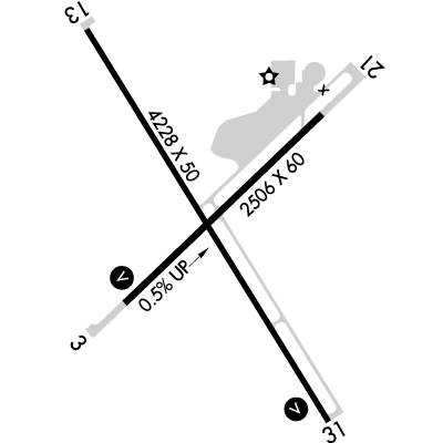
Runway 13/31
Dimensions:
4,228 × 50 ft
(1,289 × 15 m)
(1,289 × 15 m)
Weight Bearing Cap:
Single wheel: 12,000 lbs
Surface:
asphalt, no surface treatment, in good condition
Runway Edge Lights:
Medium
Comments:
n/a
| Designator: | 13 | 31 |
| Elevation: | 4,369.1 ft | 4,378.1 ft |
| Heading: | 132° magnetic 148° true | 312° magnetic 328° true |
| Gradient: | 0.21% up | 0.21% down |
| Traffic Pattern: | Right Pattern | Not provided. Assume LEFT traffic pattern |
| Markings: | non-precision, in Fair condition | non-precision, in Fair condition |
| Approach Lighting: | n/a |
|
| Displaced Threshold: | n/a | n/a |
| ILS/LOC: | n/a | n/a |
| Obstructions: | Road, 150 ft Left ft of center, 16 ft high, 300 ft from end, 6:1 clearance slope | Railroad, 250 ft Left ft of center, 15 ft high, 250 ft from end, 3:1 clearance slope |
| Comments: | Ry 13 Approach Ratio 28:1 Fm Dsplcd Thr. FAA | n/a |
Runway 03/21
Dimensions:
2,506 × 60 ft
(764 × 18 m)
(764 × 18 m)
Weight Bearing Cap:
Single wheel: 12,000 lbs
Surface:
asphalt, no surface treatment, in good condition
Runway Edge Lights:
Low
Comments:
Gross Pavement Strength Provided by Airport Manager.
FAA
| Designator: | 03 | 21 |
| Elevation: | 4,365.4 ft | 4,378 ft |
| Heading: | 030° magnetic 046° true | 210° magnetic 226° true |
| Gradient: | 0.5% up | 0.5% down |
| Traffic Pattern: | Left Pattern | Right Pattern |
| Markings: | basic, in Fair condition | basic, in Fair condition |
| Approach Lighting: |
| n/a |
| Displaced Threshold: | n/a | n/a |
| ILS/LOC: | n/a | n/a |
| Obstructions: | Railroad, Both-Sides, 23 ft high, 275 ft from end, 3:1 clearance slope | Tree, 20 ft high, 380 ft from end, 9:1 clearance slope |
| Comments: | Rwy 03 Approach Ratio 22:1 Fm Dsplcd Thld. FAA | Rw 21 Approach Ratio 35:1 Fm Dsplcd Thld. FAA |
TFRs
Location: AAT
Please verify all content below using the FAA TFR Search Site or with a flight briefer.
TFR count: 0
NOTAMs
Location: AAT
Please verify all content below using the FAA NOTAM Search Site or with a flight briefer.
NOTAM count: 1
| Number: | Start Date: (UTC) | End Date: (UTC) | Condition: |
|---|---|---|---|
| 11/002 | 11/15/2024 1311 | RWY 31 RWY END ID LGT U/S | |
Additional Remarks
Arrivals Ry 21 Discouraged Due to School on Apch.
Source:
FAA
Federal Aviation Administration
Deer on and in the Vicinity of Arpt.
Source:
FAA
Federal Aviation Administration
Fire Fightting Acft Seasonal May-Oct.
Source:
FAA
Federal Aviation Administration
For Clearance Delivery Contact Seattle ARTCC at 253-351-3694.
Source:
FAA
Federal Aviation Administration
No Tkof Ry 03 to Northeast Excp Durg Adverse Wind Cond. 150 Ft Min Alt Over Houses.
Source:
FAA
Federal Aviation Administration
Wildlife Refuges to the Sw; South and Southeast Present Potential Bird Hazards to Acft from Oct Thru Apr.
Source:
FAA
Federal Aviation Administration
Noise Abatement
Instrument Procedures
Data Cycle:
Operations & More Information
Lat/Long:
- 41.48286, -120.56542
- 41° 28′ 58.3″ N, 120° 33′ 55.5″ W
- 41° 28.972′ N, 120° 33.925′ W
ARTCC:
Seattle (ZSE)
App/Depart Control Facility:
Unknown
Chart:
NACO: Klamath Falls Sectional
FSS:
Reno (RNO)
1-800-WX-BRIEF
1-800-WX-BRIEF
Wind Indicator:
Lighted
Mag Var:
16E (2005)
NOTAM Facility:
Seg Circle:
Yes
Beacon:
Present
Lighting:
Pilot Activated Lighting:
- low intensity: 3 clicks in 3 secs
- medium intensity: 5 clicks in 5 secs
- high intensity: 7 clicks in 7 secs
AM
Actvt REIL Rwy 03 & 31; VASI Rwy 03; MIRL Rwy 13/31; Lirl Rwy 03/21 - CTAF.
FAA
Pattern Altitude:
No data provided. Assume 1000 AGL.
Special Operations:
Communications Card
| Type: | Frequency / Phone: | Sector / Comments: | Call Sign: |
|---|---|---|---|
| ASOS | 124.175T (530) 708-6221 | ||
| Clearance Delivery Phone | (253) 351-3694 | Seattle ARTCC | |
| CTAF | 122.8 | ||
| UNICOM | 122.8 |
Navaids
Services
Fuel:
100LL Low-Lead, Jet A
AM
Engine Repair:
None
Airframe Repair:
None
Bottled Oxygen:
None
Bulk Oxygen:
None
Customs:
None
Transportation:
Courtesy Transportation
AM
Activities:
None Reported
Camping On Field:
None Reported
Aircraft & Activity
Webcams
METARs
TAFs
Contact Addresses
Airport Manager
Warren Farnam
Alturas, CA 96101
(530) 233-2377 (Office)
Owner
City of Alturas
Alturas, CA 96101
(530) 233-2512 (Office)
Remarks:
Dir. of Public Works (530) 233-2377.
FAA
Operd by City of Alturas.
FAA
Public Works in Alturas. FBO At Airport 530-233-5125 or 530-708-1852.
FAA