FAA Information Effective: May 15, 2025
All information is provided from the FAA unless otherwise noted.
(KHRJ) Harnett Regional Jetport Airport
1 rating | 6 reviews
Overview
Attendance:
Attended
Year-round, 7 Days a Week,0800-1700
FAA
Runways:
05/23
Runway length: 5,005 ft (1,526 m)
Elevation:
202 ft (Surveyed)
Tower:
No
Airspace:
Unknown
Fees:
Hangar, Landing, Parking, Other
Click FBO link(s) below for details:
Click FBO link(s) below for details:
FBO Fee Details:
Harnett Regional JetportTimezone:
EDT (UTC-04:00)
Sunrise-Sunset:
6:11 am - 8:14 pm
Evening-Morning Civil Twilight:
8:42 pm
(Today)
(Today)
-
5:41 am
(Tomorrow)
(Tomorrow)
Minimum Fuel Prices:
$4.60
100LL (full)
$4.60
100LL (self)
$4.53
Jet-A-Premix/Prist (full)
Runway
Satellite
Sectional
FBOs
Submit New FBO
Harnett Regional Jetport
No ratings | Be the first to review this business
Services Offered:
$4.60 | 100LL | full
$4.60 | 100LL | self
$4.53 | Jet-A-Premix/Prist | full
Location:
On field: CTR
Phone:
(910) 814-2740
Freq. Monitored:
UNICOM: 122.7
Fees:
Hangar, Landing, Parking, Other
Flight Training
Submit New Flight School
Other businesses
Submit New Business
AOPA Travel Discounts 
FlightBridge is the ultimate all-in-one travel booking platform built for the general aviation community. AOPA Members receive free access to FlightBridge with AOPA discounted rates automatically applied. Members save an average of 30% on hotel bookings! Learn more about FlightBridge HERE.
Local Food/Lodging/Activities
Local Attractions
Local Activities
Restaurants
Hotels and Lodging
Travel Discounts
Flying Clubs
Submit New Flying Club
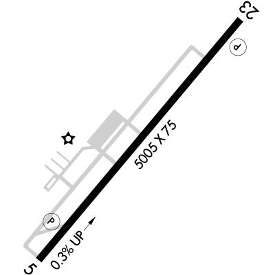
Runway 05/23
Dimensions:
5,005 × 75 ft
(1,526 × 23 m)
(1,526 × 23 m)
Weight Bearing Cap:
Single wheel: 45,000 lbs
Double wheel: 60,000 lbs
Double wheel: 60,000 lbs
Surface:
asphalt, no surface treatment, in excellent condition
Runway Edge Lights:
Medium
Comments:
n/a
| Designator: | 05 | 23 |
| Elevation: | 187.9 ft | 201.7 ft |
| Heading: | 048° magnetic 040° true | 228° magnetic 220° true |
| Gradient: | 0.28% up | 0.28% down |
| Traffic Pattern: | Not provided. Assume LEFT traffic pattern | Not provided. Assume LEFT traffic pattern |
| Markings: | non-precision, in Good condition | non-precision, in Good condition |
| Approach Lighting: |
|
|
| Displaced Threshold: | n/a | n/a |
| ILS/LOC: | LOC/DME | n/a |
| Obstructions: | n/a | Trees, 172 ft Right ft of center, 96 ft high, 2,593 ft from end, 24:1 clearance slope |
| Comments: | n/a | n/a |
TFRs
Location: HRJ
Please verify all content below using the FAA TFR Search Site or with a flight briefer.
TFR count: 0
NOTAMs
Location: HRJ
Please verify all content below using the FAA NOTAM Search Site or with a flight briefer.
NOTAM count: 7
| Number: | Start Date: (UTC) | End Date: (UTC) | Condition: |
|---|---|---|---|
| 05/007 | 05/13/2025 0830 | 09/10/2025 0830 | OBST TOWER LGT (ASR 1288695) 351726.70N0785911.20W (13.7NM WSW HRJ) 539.0FT (258.2FT AGL) U/S |
| 05/006 | 05/12/2025 1518 | 06/05/2025 2359 | COM REMOTE TRANS/REC 125.175 U/S USE 120.35 |
| 5/1791 | 04/26/2025 0820 | IAP HARNETT RGNL JETPORT, ERWIN, NC.
LOC RWY 5, ORIG-C...
MISSED APPROACH: CLIMB TO 800 THEN CLIMBING LEFT T… | |
| 05/004 | 05/07/2025 1058 | NAV HQT NDB NOT MNT | |
| 04/005 | 04/24/2025 0530 | 06/08/2025 0529 | OBST TOWER LGT (ASN 2021-ASO-9341-OE) 352006N0783921W (4.6NM SE HRJ) 522FT (318FT AGL) U/S |
| 05/009 | 05/15/2025 1917 | 09/12/2025 1917 | OBST TOWER LGT (ASR 1004806) 352426.00N0785123.00W (6.2NM WNW HRJ) 735.9FT (415.0FT AGL) U/S |
| 05/010 | 05/15/2025 1933 | 09/12/2025 1933 | OBST TOWER LGT (ASR 1005127) 352204.00N0783052.00W (10.6NM E HRJ) 647.0FT (417.0FT AGL) U/S |
Additional Remarks
Airport Located 18 Nm Northeast of Pope Army Airfield, Low Level Mil Act In vicinity of Arpt.
Source:
FAA
Federal Aviation Administration
For Clearance Delivery Contact Fayetteville Approach at 910-484-8012.
Source:
FAA
Federal Aviation Administration
Rotg Bcn Obsc by Trees N & W of Arpt.
Source:
FAA
Federal Aviation Administration
Rwy 05, 60 Ft Drop-Off 350 Ft Fm Thr & Rwy 23, 25 Ft Drop-Off 70 Ft Left of Cntrln.
Source:
FAA
Federal Aviation Administration
Svc Avbl 24/7 with Prior Arngmnts. Gpu and Bulk Oil Avbl.
Source:
FAA
Federal Aviation Administration
Noise Abatement
Instrument Procedures
Data Cycle:
Operations & More Information
Lat/Long:
- 35.38016, -78.73224
- 35° 22′ 48.6″ N, 78° 43′ 56.1″ W
- 35° 22.809′ N, 78° 43.934′ W
ARTCC:
Washington (ZDC)
App/Depart Control Facility:
FAY
Chart:
NACO: Charlotte Sectional
FSS:
Raleigh (RDU)
1-800-WX-BRIEF
1-800-WX-BRIEF
Wind Indicator:
Lighted
Mag Var:
08W (2000)
NOTAM Facility:
Seg Circle:
Yes
Beacon:
Present
Lighting:
Actvt REIL Rwy 05 & Rwy 23; MIRL Rwy 05/23 - CTAF; PAPI Rwy 05 & Rwy 23 on Consly.
FAA
Pattern Altitude:
No data provided. Assume 1000 AGL.
Special Operations:
Communications Card
| Type: | Frequency / Phone: | Sector / Comments: | Call Sign: |
|---|---|---|---|
| Approach/Departure | 125.175 | Fayetteville | |
| AWOS-3 | 119.025T (910) 814-3946 | ||
| CLASS C | 125.175 | Fayetteville | |
| Clearance Delivery Phone | (910) 484-8012 | Fayetteville Approach | |
| CTAF | 122.7 | ||
| UNICOM | 122.7 |
Navaids
Services
Fuel:
100LL Low-Lead, Jet A1 +Icing Inhibitor
AM
Engine Repair:
Major
AM
Airframe Repair:
Major
AM
Bottled Oxygen:
High/Low
AM
Bulk Oxygen:
None
Customs:
None
Transportation:
Courtesy Transportation
AM
Activities:
None Reported
Camping On Field:
None Reported
Aircraft & Activity
Webcams
METARs
TAFs
Contact Addresses
Airport Manager
Bradley Abate
Erwin, NC 28339
(910) 814-2740 (Office)
Owner
Harnett County
Erwin, NC 28339
(910) 814-2740 (Office)
Remarks:
Coley Price, Asst County Mgr.
FAA
Airport Reviews
Overall:
1 rating | 6 reviews
Runways and Taxiways:No ratings
Markings and Signage:No ratings
Ground Transportation:No ratings
Sort By:
- 4/16/18Rick I.Great airport. Stopped by on the way from NY to Sun n Fun. Great fuel prices, lowest in the region and for full serve. Discounted oil for the week. To top it off they were offering free bbq and cookies for lunch. Nice people. Will be back ne…
- 4/8/15MEREDITH H.I can't say enough good things about this airport and the staff. I went NORDO on my way to KFAY and diverted to KHRJ to troubleshoot the problem. It was my first visit, but it certainly will not be my last. Great fuel prices and friendly staff. They …
- 1/25/15SCOTT B.They have the best fuel prices in the triangle area and their staff is always on top of their game. I go out of my way to fly into KHRJ.
- 7/18/14JEFFREY P.Above and beyond customer service and outstanding new runway / taxiways. I flew in for the Free Lunch they hold every 1st & 3rd Friday of the month and cheapest 100LL around. Friendly staff who filled my plane up at the self-serve pump and towed to p…
- 3/10/14VICENTE C.Outstanding facility and personnel. The runway and taxiways were recently resurfaced and are as smooth as glass. Manager Josh Pusser and his staff are as good or better than you will find at any other FBO large or small. When I arrived Fri, it was sp…
- 2/23/14TERRY T.Excellent facility, excellent service! The Warren Aviation service attendance was at the fuel pump before we even taxied up to the pump. And they have the cheapest fuel within 100 miles! The glider activity mentioned in the comments section are no lo…