FAA Information Effective: May 15, 2025
All information is provided from the FAA unless otherwise noted.
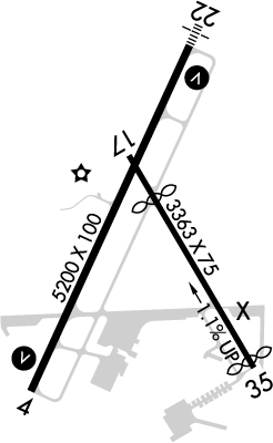
(KBHB) Hancock County/Bar Harbor Airport
1 rating | 3 reviews
Overview
Attendance:
Attended
Year-round, 7 Days a Week,0800-1800
FAA
Elevation:
83 ft (Surveyed)
Tower:
No
Airspace:
E
Fees:
Timezone:
EDT (UTC-04:00)
Sunrise-Sunset:
4:53 am - 8:11 pm
Evening-Morning Civil Twilight:
8:47 pm
(Today)
(Today)
-
4:17 am
(Tomorrow)
(Tomorrow)
Minimum Fuel Prices:
$6.84
100LL (full)
$6.76
Jet-A (full)
$6.91
Jet-A-Premix/Prist (full)
Runway
Satellite
Sectional
FBOs
Submit New FBO
Modern Aviation
1 rating | 3 reviews
Services Offered:
Maintenance
Car Rental
Sales
$6.84 | 100LL | full
$6.76 | Jet-A | full
$6.91 | Jet-A-Premix/Prist | full
Location:
On field: S
Phone:
(207) 667-5534
Freq. Monitored:
UNICOM: 123
ASRI: 131.4
ASRI: 131.4
Fees:
Hangar, Overnight, Ramp, Other
Flight Training
Submit New Flight School
Other businesses
Submit New Business
AOPA Travel Discounts 
FlightBridge is the ultimate all-in-one travel booking platform built for the general aviation community. AOPA Members receive free access to FlightBridge with AOPA discounted rates automatically applied. Members save an average of 30% on hotel bookings! Learn more about FlightBridge HERE.
Local Food/Lodging/Activities
Local Attractions
Local Activities
Restaurants
Hotels and Lodging
Travel Discounts
(207) 667-5661
(207) 667-2930
(207) 667-8452
Down East Lobster
(207) 667-8589
Lunt's Gateway Lobster Pound
(207) 667-2620
(207) 667-2977
BHB
Isleview Motel and Cottages
Open Hearth Inn
Acadia Sunrise Motel
Mount Desert Oceanarium
Down East Lobster
Lunt's Gateway Lobster Pound
Trenton Bridge Lobster
Flying Clubs
Submit New Flying Club
Runway 04/22
Dimensions:
5,200 × 100 ft
(1,585 × 30 m)
(1,585 × 30 m)
Weight Bearing Cap:
Double wheel: 72,000 lbs
Double tandem: 100,000 lbs
Double tandem: 100,000 lbs
Surface:
asphalt, no surface treatment, in good condition
Runway Edge Lights:
High
Comments:
Due to Hump At Midpt, Opposite Ends of Rwy not Vsb At Gnd Level.
FAA
Pcr Value: 350/F/D/X/T
FAA
| Designator: | 04 | 22 |
| Elevation: | 69 ft | 69.1 ft |
| Heading: | 044° magnetic 025° true | 224° magnetic 205° true |
| Gradient: | n/a | n/a |
| Traffic Pattern: | Left Pattern | Left Pattern |
| Markings: | non-precision, in Good condition | precision, in Good condition |
| Approach Lighting: |
|
|
| Displaced Threshold: | n/a | n/a |
| ILS/LOC: | n/a | ILS/DME |
| Obstructions: | Trees, 500 ft Left ft of center, 125 ft high, 1,410 ft from end, 9:1 clearance slope | n/a |
| Comments: | n/a | n/a |
Runway 17/35
Dimensions:
3,363 × 75 ft
(1,025 × 23 m)
(1,025 × 23 m)
Weight Bearing Cap:
Single wheel: 13,000 lbs
Double wheel: 20,000 lbs
Double wheel: 20,000 lbs
Surface:
asphalt, no surface treatment, in good condition
Runway Edge Lights:
n/a
Comments:
Not Avbl for Skedd Acr Operations (Ldg & Tkof) More Than 9 Pax Seats or Unsked Acr Operations At Least 31 Pax Seats. Rwy 17/35 N of Twy H Avbl for Acr Operations More Than 9 Pax Seats for Taxi Only.
FAA
Pcr Value: 40/F/D/Y/U
FAA
| Designator: | 17 | 35 |
| Elevation: | 78.6 ft | 43 ft |
| Heading: | 169° magnetic 150° true | 349° magnetic 330° true |
| Gradient: | 1.06% down | 1.06% up |
| Traffic Pattern: | Left Pattern | Left Pattern |
| Markings: | basic, in Good condition | basic, in Good condition |
| Approach Lighting: | n/a | n/a |
| Displaced Threshold: | 684 ft | 111 ft |
| ILS/LOC: | n/a | n/a |
| Obstructions: | Tree, 60 ft Right ft of center, 148 ft high, 900 ft from end, 5:1 clearance slope | n/a |
| Comments: | 10:1 to Dthr. FAA | n/a |
TFRs
Location: BHB
Please verify all content below using the FAA TFR Search Site or with a flight briefer.
TFR count: 0
NOTAMs
Location: BHB
Please verify all content below using the FAA NOTAM Search Site or with a flight briefer.
NOTAM count: 5
| Number: | Start Date: (UTC) | End Date: (UTC) | Condition: |
|---|---|---|---|
| 05/025 | 05/19/2025 1539 | 10/31/2025 2359 | RWY 22 LEFT TFC PATTERN |
| 05/036 | 05/29/2025 1843 | NAV ILS RWY 22 NOT MNT | |
| 5/8440 | 04/18/2025 2113 | IAP HANCOCK COUNTY/BAR HARBOR, BAR HARBOR, ME.
ILS OR LOC RWY 22, AMDT 6F...
DISREGARD NOTE: AUTOPILOT COUPL… | |
| 05/020 | 05/16/2025 1215 | 06/30/2025 2000 | TWY H HLDG PSN MARKINGS BTN RWY 17/35 AND APCH END RWY 22 NOT STD |
| 05/021 | 05/16/2025 1216 | 06/30/2025 2000 | TWY H HLDG PSN MARKINGS NOT STD |
Additional Remarks
48 Hr Prior Permission Required for Unsked Acr Operations At Least 31 Pax Seats. CTC Amgr.
Source:
FAA
Federal Aviation Administration
Birds on & In vicinity of Arpt.
Source:
FAA
Federal Aviation Administration
Durg VFR Conds When Wind Speed Less Than 5 Kts As Rprtd by Awos or Unicom, All Acft Using Rwy 04/22 are Reqd to Tkof & Land on Rwy 22 for Noise Abatement Procs.
Source:
FAA
Federal Aviation Administration
Ficon not Mnt Mon-Fri 2100-0730, Wkends & Hols.
Source:
FAA
Federal Aviation Administration
Grass Areas Unavbl for Acft Ops.
Source:
FAA
Federal Aviation Administration
If Cd Freq Unavbl CTC Bangor Approach at 207-561-2500 Ext 1.
Source:
FAA
Federal Aviation Administration
Ppr for Overweight Ldgs. Prior Permission Required for Unsked Acr Operations Rqrg 14 Cfr 139 Arff. CTC Amgr.
Source:
FAA
Federal Aviation Administration
Seaplane Ramp Unavbl for Acft Operations Exc Prior Permission Required 207-667-7329.
Source:
FAA
Federal Aviation Administration
Twy Bravo Clsd to All Acft Gtr Than 10000 Lbs.
Source:
FAA
Federal Aviation Administration
Twys F & G Clsd Dec 1- Mar 31 Annually.
Source:
FAA
Federal Aviation Administration
Noise Abatement
Instrument Procedures
Data Cycle:
Operations & More Information
Lat/Long:
- 44.44971, -68.36149
- 44° 26′ 58.9″ N, 68° 21′ 41.4″ W
- 44° 26.982′ N, 68° 21.689′ W
ARTCC:
Boston (ZBW)
App/Depart Control Facility:
BGR
Chart:
NACO: Halifax Sectional
FSS:
Bangor (BGR)
1-800-WX-BRIEF
1-800-WX-BRIEF
Wind Indicator:
Yes
Mag Var:
19W (1985)
NOTAM Facility:
Seg Circle:
Yes
Beacon:
Present
Lighting:
Pilot Activated Lighting:
- low intensity: 3 clicks in 3 secs
- medium intensity: 5 clicks in 5 secs
- high intensity: 7 clicks in 7 secs
AM
Actvt Malsf Rwy 22; REIL Rwy 04; VASI Rwy 04 & 22; HIRL Rwy 04/22 - 122.7.
FAA
Pattern Altitude:
No data provided. Assume 1000 AGL.
Special Operations:
Communications Card
| Type: | Frequency / Phone: | Sector / Comments: | Call Sign: |
|---|---|---|---|
| Approach/Departure IC | 133.6 | Bangor | |
| AWOS-3PT | 118.35T (207) 667-7364 | ||
| Clearance Delivery | 119.9 | Bangor | |
| CTAF | 123.0 | ||
| UNICOM | 123.0 |
Navaids
Services
Fuel:
100LL Low-Lead, Jet A
AM
Engine Repair:
Minor
AM
Airframe Repair:
Minor
AM
Bottled Oxygen:
None
Bulk Oxygen:
None
Customs:
None
Transportation:
Courtesy Transportation, Limousine, Public Transportation, Shuttle Service, Van
AM
Activities:
Intensive Flight Training
AM
Camping On Field:
None Reported
Aircraft & Activity
Webcams
METARs
TAFs
Contact Addresses
Airport Manager
Leroy Muise
Trenton, ME 04605
(207) 667-7329 (Office)
Owner
Hancock County
Ellsworth, ME 04605
(207) 667-9542 (Office)
Airport Reviews
Overall:
1 rating | 3 reviews
Runways and Taxiways:No ratings
Markings and Signage:No ratings
Ground Transportation:No ratings
Sort By:
- 8/21/18Eric H.
- 6/23/14DANIEL C.Spoke to Kathy at Columbia about our upcoming trip to Bar Harbor. She was extremely accommodating. We will need a car during our stay and she not only set up the car rental for us but advised me that our credit card with the rental car company had ex…
- 6/8/14WILLIAM G.My wife and I flew in to KBHB this past Saturday. The staff at Columbia were outstanding, helping to tie down the aircraft and shuttling my wife and me to the terminal to pick up a rental car. They loaded all the gear in the car while I filled out th…
- 6/6/14SETH H.Flew in with my Mom for some ice cream and windown shopping in town. Columbia let me borrow their Pontiac Vibe for a couple hours. Great time, thanks.