FAA Information Effective: Apr 17, 2025
All information is provided from the FAA unless otherwise noted.
(W35) Potomac Airpark
3 ratings | 6 reviews
Berkeley Springs, WV
(301) 842-3700
Overview
Attendance:
Attended
Irregular
FAA
Runways:
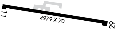
11/29
Runway length: 4,979 ft (1,518 m)
Elevation:
413 ft (Surveyed)
Tower:
No
Airspace:
Unknown
Fees:
None
Timezone:
EDT (UTC-04:00)
Sunrise-Sunset:
6:00 am - 8:20 pm
Evening-Morning Civil Twilight:
8:50 pm
(Today)
(Today)
-
5:28 am
(Tomorrow)
(Tomorrow)
Runway
Satellite
Sectional
FBOs and Other Businesses
Submit New FBO
AOPA Travel Discounts 
FlightBridge is the ultimate all-in-one travel booking platform built for the general aviation community. AOPA Members receive free access to FlightBridge with AOPA discounted rates automatically applied. Members save an average of 30% on hotel bookings! Learn more about FlightBridge HERE.
Local Food/Lodging/Activities
Local Attractions
Local Activities
Restaurants
Hotels and Lodging
Travel Discounts
Flying Clubs
Submit New Flying Club
Runway 11/29
Dimensions:
4,979 × 70 ft
(1,518 × 21 m)
(1,518 × 21 m)
Weight Bearing Cap:
n/a
Surface:
asphalt, no surface treatment, in poor condition
Runway Edge Lights:
Medium
Comments:
Pavement Spalling, Cracks, Uneven Surface. Loose Aggregate and Stones. Vegetation Growing Through Pavement.
FAA
| Designator: | 11 | 29 |
| Elevation: | 409.9 ft | 411.5 ft |
| Heading: | 110° magnetic 100° true | 290° magnetic 280° true |
| Gradient: | 0.03% up | 0.03% down |
| Traffic Pattern: | Left Pattern | Right Pattern |
| Markings: | n/a | n/a |
| Approach Lighting: | n/a | n/a |
| Displaced Threshold: | n/a | n/a |
| ILS/LOC: | n/a | n/a |
| Obstructions: | Trees, 110 ft Right ft of center, 60 ft high, 201 ft from end | Trees, 110 ft Right ft of center, 40 ft high, 201 ft from end |
| Comments: | 60 Ft Trees; Up to 200 Ft Dstc, 110 Ft Left. FAA No Mkgs. FAA | 40 Ft Trees; At Thld, 10 Ft Right. FAA |
TFRs
Location: W35
Please verify all content below using the FAA TFR Search Site or with a flight briefer.
TFR count: 0
NOTAMs
Location: W35
Please verify all content below using the FAA NOTAM Search Site or with a flight briefer.
NOTAM count: 6
| Number: | Start Date: (UTC) | End Date: (UTC) | Condition: |
|---|---|---|---|
| 4/2609 | 04/18/2024 1523 | IAP POTOMAC AIRPARK, BERKELEY SPRINGS, WV.
RNAV (GPS) RWY 11, AMDT 1A...
RNAV (GPS) RWY 29, AMDT 1A...
PROCE… | |
| 04/125 | 04/16/2025 0445 | 07/15/2025 0400 | OBST TOWER LGT (ASR 1234928) 394715.80N0781219.40W (6.0NM NNW W35) 1086.9FT (265.1FT AGL) U/S |
| 04/214 | 04/28/2025 1854 | 08/26/2025 1854 | OBST TOWER LGT (ASR 1036848) 393945.00N0775753.00W (9.4NM E W35) 1868.8FT (460.0FT AGL) U/S |
| 04/128 | 04/16/2025 1242 | 05/31/2025 1242 | OBST TOWER LGT (ASR 1035988) 394118.20N0781800.70W (6.2NM W W35) 1812.7FT (253.0FT AGL) U/S |
| 03/086 | 03/15/2025 0844 | 06/30/2025 2359 | OBST TOWER LGT (ASR 1036893) 394112.30N0781806.00W (6.2NM W W35) 1792.0FT (211.9FT AGL) U/S |
| 05/065 | 05/08/2025 2133 | 09/05/2025 2133 | OBST TOWER LGT (ASR 1026727) 394552.60N0781349.70W (5.2NM NW W35) 1269.0FT (419.9FT AGL) U/S |
Additional Remarks
8 Ft Crops, 50-80 Ft R/L Rwy Cl.
Source:
FAA
Federal Aviation Administration
Airport Clsd Nights.
Source:
FAA
Federal Aviation Administration
Airport Entrance Gate Locked. No Public Access to Airport.
Source:
FAA
Federal Aviation Administration
Birds & Wildlife In vicinity of Arpt.
Source:
FAA
Federal Aviation Administration
Drag Racing on Rwy. Extsv Rubber Build Up on Rwy 29 Pavement End.
Source:
FAA
Federal Aviation Administration
For Clearance Delivery Contact Potomac Approach at 866-709-4993.
Source:
FAA
Federal Aviation Administration
No Acft Over 18500 Lbs Gwt.
Source:
FAA
Federal Aviation Administration
Rc Model Acft Oper on Arpt.
Source:
FAA
Federal Aviation Administration
Rwy 11 Approach End, 10 Ft Drop Off, 30 Ft from Pavement End. Rwy 29 15 Ft Drop Off, 30 Ft Fm Rwy End.
Source:
FAA
Federal Aviation Administration
Rwy 29 End, Possibility of 12 Ft Grandstand on Each Side of Rwy, 13 Ft. Fm Rwy Edge.
Source:
FAA
Federal Aviation Administration
Unmanned Acft 1000/Blw 1 Nmr of Arpt.
Source:
FAA
Federal Aviation Administration
Noise Abatement
Instrument Procedures
Data Cycle:
Operations & More Information
Lat/Long:
- 39.69261, -78.16608
- 39° 41′ 33.4″ N, 78° 9′ 57.9″ W
- 39° 41.557′ N, 78° 9.965′ W
ARTCC:
Washington (ZDC)
App/Depart Control Facility:
PCT
Chart:
NACO: Washington Sectional
FSS:
Elkins (EKN)
1-800-WX-BRIEF
1-800-WX-BRIEF
Wind Indicator:
Lighted
Mag Var:
10W (2000)
NOTAM Facility:
Seg Circle:
No
Beacon:
Not Present
Lighting:
No lighting reported.
Pattern Altitude:
No data provided. Assume 1000 AGL.
Special Operations:
Communications Card
| Type: | Frequency / Phone: | Sector / Comments: | Call Sign: |
|---|---|---|---|
| Approach/Departure | 126.825 | Potomac | |
| Clearance Delivery Phone | (866) 709-4993 | Potomac Approach | |
| CTAF | 122.9 |
Navaids
Services
Aircraft & Activity
Webcams
METARs
TAFs
Contact Addresses
Airport Manager
Riverside Airpark, LLC
Clear Spring, MD 21722-1605
(301) 842-3700 (Office)
Owner
Riverside Airpark, LLC
Clear Spring, MD 21722-1605
(301) 842-3700 (Office)
Airport Reviews
Overall:
3 ratings | 6 reviews
Runways and Taxiways:
Markings and Signage:
Ground Transportation:
Sort By:
- 1/23/20strange placeGerald E.Flew in this afternoon in an Archer since it's close to our camp in WV. The runway is in very poor shape. Rolled out and there were three people there with a car (hood up) and a pickup. Perhaps drag racing as the AFD describes? Two of them walked t…
- 4/26/24Cleared for Touch and GoThomas J.Performed low approach and followed with a touch and go on 29. No debris visible on runway, despite heavy rubber slicks from racing. Bleachers set up midfield on north side, clear of runway. Sufficient space near bleachers to taxi clear and park; use…
- 5/8/22Airport is Usable With CautionKeith M.I have friends that live in Berkeley Springs, about 6 miles from the airport. It took me a few years of visiting by car to find out that I can fly there. There are local pilots who have hangers there and use the airport. A gate at the entrance by "1…
- 3/25/16KENNETH B.Was in the area by car in November 2016. Access via car is at the approach end of 29, if you have a key. Drive through/past the silver rail yard building until you reach a concrete bridge with a steel swing gate, which is locked. No activities were …
- 7/17/15ORA T.No one seems to have any accurate information on this airport. I tried calling the number listed as the Airport Manager (301-842-3700) but it would just disconnect after a few rings. I then tried calling the phone number listed as the "phone at airpo…
- 6/14/13MIKE D.Just called the 301-842-3700 number and you get a nice lady with the masonry company. The airport is private use, so you need to give them notice. If you want to leave the airport, you need to mention that you need the gate unlocked. There are no res…