FAA Information Effective: May 15, 2025
All information is provided from the FAA unless otherwise noted.
(KTUL) Tulsa International Airport
No ratings | No reviews
Overview
Attendance:
Attended
Year-round, 7 Days a Week,All
FAA
Elevation:
678 ft (Surveyed)
Tower:
Primary Approach Control Hrs: 24
FAA
Primary Depart. Control Hrs: 24
FAA
Tower Hrs: 24
FAA
Airspace:
C
Fees:
Landing, Parking, Ramp, Tie Down, Other
Click FBO link(s) below for details:
Sparks Aviation Center / Autopilots Central
United States Aviation
Click FBO link(s) below for details:
FBO Fee Details:
Atlantic AviationSparks Aviation Center / Autopilots Central
United States Aviation
Timezone:
CDT (UTC-05:00)
Sunrise-Sunset:
6:13 am - 8:30 pm
Evening-Morning Civil Twilight:
8:59 pm
(Today)
(Today)
-
5:43 am
(Tomorrow)
(Tomorrow)
Minimum Fuel Prices:
$5.70
100LL (full)
$4.55
Jet-A-Premix/Prist (full)
$5.14
Jet-A (full)
Runway
Satellite
Sectional
FBOs
Submit New FBO
Atlantic Aviation
No ratings | Be the first to review this business
Services Offered:
Car Rental
$7.59 | 100LL | full
$6.18 | Jet-A | full
Location:
On field: W
Phone:
(918) 836-6592
Freq. Monitored:
ASRI: 130.1
Fees:
Parking, Other
Sparks Aviation Center / Autopilots Central
No ratings | 1 review
Services Offered:
Maintenance
Car Rental
Sales
$5.70 | 100LL | full
$4.55 | Jet-A-Premix/Prist | full
Location:
On field: N
Phone:
(918) 835-2048
Freq. Monitored:
UNICOM: 122.95
Fees:
Landing, Ramp, Tie Down, Other
United States Aviation
1 rating | 1 review
Services Offered:
Car Rental
$5.14 | Jet-A | full
$5.55 | Jet-A-Premix/Prist | full
Location:
On field: NW
Phone:
(918) 836-7345
Freq. Monitored:
UNICOM: 122.95
Fees:
Other
Flight Training
Submit New Flight School
Other businesses
Submit New Business
AOPA Travel Discounts 
FlightBridge is the ultimate all-in-one travel booking platform built for the general aviation community. AOPA Members receive free access to FlightBridge with AOPA discounted rates automatically applied. Members save an average of 30% on hotel bookings! Learn more about FlightBridge HERE.
Local Food/Lodging/Activities
Local Attractions
Local Activities
Restaurants
Hotels and Lodging
Travel Discounts
3624 N 74th E Ave, Tulsa, OK 74115
(918) 834-9900
6421 E 36th St N, Tulsa, OK 74115
(918) 669-6600
3014 N 74th E Ave, Tulsa, OK 74115
(918) 835-1212
7728 E Virgin Ct, Tulsa, OK 74115
(918) 838-1444
TUL
Tulsa Air and Space Museum
Tulsa Zoo
Evelyn's Soul Food (Mon-Fri: 9am-3pm)
Hilton Garden Inn Tulsa Airport
Flying Clubs
Submit New Flying Club
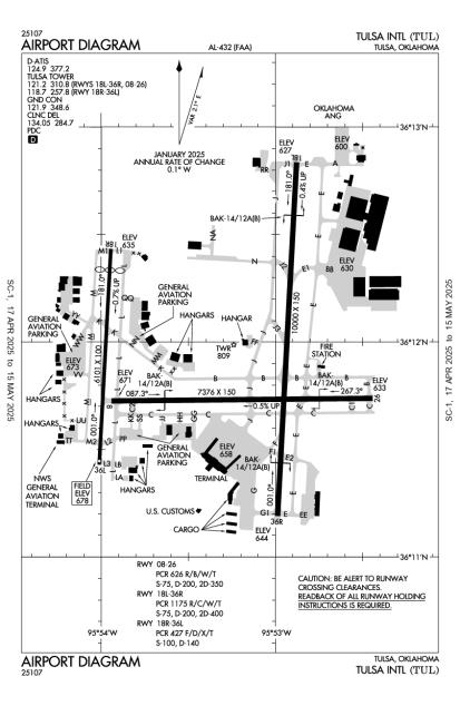
Runway 18L/36R
Dimensions:
10,000 × 150 ft
(3,048 × 46 m)
(3,048 × 46 m)
Weight Bearing Cap:
Single wheel: 75,000 lbs
Double wheel: 200,000 lbs
Double tandem: 400,000 lbs
Double wheel: 200,000 lbs
Double tandem: 400,000 lbs
Surface:
concrete, grooved, in excellent condition
Runway Edge Lights:
High
Comments:
Pcr Value: 1175/R/C/W/T
FAA
| Designator: | 18L | 36R |
| Elevation: | 626.6 ft | 643.8 ft |
| Heading: | 180° magnetic 183° true | 000° magnetic 003° true |
| Gradient: | 0.17% up | 0.17% down |
| Traffic Pattern: | Left Pattern | Right Pattern |
| Markings: | precision, in Good condition | precision, in Good condition |
| Approach Lighting: |
|
|
| Displaced Threshold: | n/a | n/a |
| ILS/LOC: | ILS/DME | ILS/DME |
| Obstructions: | Tree, 41 ft high, 1,894 ft from end, 41:1 clearance slope | Tree, 127 ft Right ft of center, 29 ft high, 1,593 ft from end, 48:1 clearance slope |
| Comments: | Bak-14 Bak-12A(B) (1500 Ft). FAA | Bak-14 Bak-12A(B) (1500 Ft). FAA |
Runway 08/26
Dimensions:
7,376 × 150 ft
(2,248 × 46 m)
(2,248 × 46 m)
Weight Bearing Cap:
Single wheel: 75,000 lbs
Double wheel: 200,000 lbs
Double tandem: 350,000 lbs
Double wheel: 200,000 lbs
Double tandem: 350,000 lbs
Surface:
concrete, grooved, in fair condition
Runway Edge Lights:
High
Comments:
Pcr Value: 626/R/B/W/T
FAA
| Designator: | 08 | 26 |
| Elevation: | 671.2 ft | 633 ft |
| Heading: | 086° magnetic 089° true | 266° magnetic 269° true |
| Gradient: | 0.52% down | 0.52% up |
| Traffic Pattern: | Left Pattern | Left Pattern |
| Markings: | non-precision, in Good condition | non-precision, in Good condition |
| Approach Lighting: |
|
|
| Displaced Threshold: | n/a | n/a |
| ILS/LOC: | n/a | n/a |
| Obstructions: | Tree, 430 ft Right ft of center, 36 ft high, 1,775 ft from end, 43:1 clearance slope | n/a |
| Comments: | Bak-14 Bak-12A(B) (1500 Ft). FAA Papi Unusbl Byd 8 Degs Left & Right of Rwy Cntrln. FAA | Bak-14 Bak-12A(B) (1500 Ft). FAA Papi Unusbl Byd 7 Degs Right & 9 Degs Left of Cntrln. FAA |
Runway 18R/36L
Dimensions:
6,101 × 100 ft
(1,860 × 30 m)
(1,860 × 30 m)
Weight Bearing Cap:
Single wheel: 100,000 lbs
Double wheel: 140,000 lbs
Double wheel: 140,000 lbs
Surface:
asphalt, grooved, in good condition
Runway Edge Lights:
High
Comments:
Pcr Value: 427/F/D/X/T
FAA
| Designator: | 18R | 36L |
| Elevation: | 634.9 ft | 677.2 ft |
| Heading: | 180° magnetic 183° true | 000° magnetic 003° true |
| Gradient: | 0.69% up | 0.69% down |
| Traffic Pattern: | Right Pattern | Left Pattern |
| Markings: | precision, in Good condition | non-precision, in Good condition |
| Approach Lighting: |
|
|
| Displaced Threshold: | 600 ft | n/a |
| ILS/LOC: | ILS | n/a |
| Obstructions: | n/a | Road, 419 ft Left ft of center, 10 ft high, 200 ft from end, 1:1 clearance slope |
| Comments: | Ireg Wind Pat. FAA | n/a |
TFRs
Location: TUL
Please verify all content below using the FAA TFR Search Site or with a flight briefer.
TFR count: 0
NOTAMs
Location: TUL
Please verify all content below using the FAA NOTAM Search Site or with a flight briefer.
NOTAM count: 12 (Partial list shown. Expand to see full list HERE.)
| Number: | Start Date: (UTC) | End Date: (UTC) | Condition: |
|---|---|---|---|
| 05/076 | 05/27/2025 1200 | 05/27/2025 1800 | NAV ILS RWY 36R U/S |
| 5/4360 | 01/17/2025 1401 | IAP TULSA INTL, TULSA, OK.
RNAV (GPS) RWY 18R, AMDT 2A...
LNAV/VNAV DA 1157/HAT 489 ALL CATS. VIS 1 3/8 ALL … | |
| 05/070 | 05/20/2025 1452 | 06/04/2025 1352 | OBST TOWER LGT (ASR 1200616) 361010.00N0955710.80W (3.6NM WSW TUL) 1151.9FT (417.0FT AGL) U/S |
| 5/7780 | 04/17/2025 0917 | IAP TULSA INTL, TULSA, OK.
ILS OR LOC RWY 18L, AMDT 16A...
ILS OR LOC RWY 18R, AMDT 9...
ILS OR LOC RWY 36R,… | |
| 01/053 | 01/17/2025 1300 | 09/30/2025 1300 | OBST CRANE (ASN 2024-ASW-8513-NRA) 361205N0955331W (0.3NM NW TUL) 946FT (300FT AGL) FLAGGED AND LGTD |
| 05/041 | 05/15/2025 0452 | 05/30/2025 0352 | OBST TOWER LGT (ASR 1277192) 360851.60N0955612.30W (3.9NM SW TUL) 885.2FT (119.1FT AGL) U/S |
| 05/077 | 05/27/2025 1200 | 05/27/2025 1800 | NAV ILS RWY 18L UNUSABLE DA TO TDZ |
| 05/074 | 05/28/2025 0500 | 05/28/2025 1100 | NAV VORTAC NOT MNT |
Additional Remarks
Apvd Acft Run Up Area: 2300-0600 N End Twy J Acft Orientation N & S. 24 Hr Approach End Rwy 26 Acft Orientation E & W. 0600-2300 N End Twy L Acft Orientation N & S.
Source:
FAA
Federal Aviation Administration
Birds on & In vicinity of Arpt.
Source:
FAA
Federal Aviation Administration
Ctn: 4000 Ft Blacktop Track 1.5 Nm E Rwy 26; Do not Mistake for Rwy.
Source:
FAA
Federal Aviation Administration
Noise Abatement All Rwys: Climb to 3000 Ft Asap Aft Tkof.
Source:
FAA
Federal Aviation Administration
Twy L South of Twy L3 not Vsb to Atct.
Source:
FAA
Federal Aviation Administration
Txl Lb not Vsb to Atct.
Source:
FAA
Federal Aviation Administration
Txls La, Lb, Nn & Qq not Vsb Fm Atct.
Source:
FAA
Federal Aviation Administration
Wt Rstrd Areas: Twy Jj S-35; Twy M2 S-81/D-140/Dt-186; Twy Hh S-55/D-60; Twy L North of Rwy 08/26 S-93/D-140/Dt 209; Twy L between Twy C & Twy L2 S-120/D-250/Dt 372; Twy L2 S-70/D-100/Dt-166.
Source:
FAA
Federal Aviation Administration
Noise Abatement
Instrument Procedures
Data Cycle:
Operations & More Information
Lat/Long:
- 36.19839, -95.88811
- 36° 11′ 54.2″ N, 95° 53′ 17.2″ W
- 36° 11.904′ N, 95° 53.286′ W
ARTCC:
Kansas City (ZKC)
App/Depart Control Facility:
Unknown
Chart:
NACO: Kansas City Sectional
FSS:
Mc Alester (MLC)
1-800-WX-BRIEF
1-800-WX-BRIEF
Wind Indicator:
Lighted
Mag Var:
03E (2020)
NOTAM Facility:
Seg Circle:
No
Beacon:
Present
Lighting:
No lighting reported.
Pattern Altitude:
No data provided. Assume 1000 AGL.
Special Operations:
Communications Card
| Type: | Frequency / Phone: | Sector / Comments: | Call Sign: |
|---|---|---|---|
| Approach/Departure | 119.1 | 355-174 | Tulsa |
| Approach/Departure IC | 124.0 | 175-354 | Tulsa |
| ASOS | (539) 399-0187 | Tulsa | |
| CD PRE TAXI CLNC | 134.05 | Tulsa | |
| CLASS C | 124.0 | 175-354 | Tulsa |
| CLASS C | 119.1 | 355-174 | Tulsa |
| D-ATIS | 124.9 | Tulsa | |
| Emergency | 121.5 | Tulsa | |
| FINAL | 132.1 | 175-354 | Tulsa |
| FINAL | 119.85 | 355-174 | Tulsa |
| Ground Control | 121.9 | Tulsa | |
| NG OPS | 46.9 | Tulsa | |
| Tower | 121.2R | RWY 08/26, 18L/36R | Tulsa |
| Tower | 118.7R | RWY 18R/36L | Tulsa |
| TULSA DP | 124.0 | Tulsa | |
| UNICOM | 122.95 | Tulsa | |
| VINTA STAR | 119.1 | Tulsa |
Navaids
Services
Fuel:
100LL Low-Lead, Jet A
AM
Engine Repair:
Major
AM
Airframe Repair:
Major
AM
Bottled Oxygen:
High/Low
AM
Bulk Oxygen:
High/Low
AM
Customs:
International Landing Rights
AM
Transportation:
Courtesy Transportation, Limousine, Public Transportation, Shuttle Service
AM
Activities:
On field aviation museum, On field restaurant/café
AM
Camping On Field:
None Reported
Aircraft & Activity
Webcams
METARs
TAFs
Contact Addresses
Airport Manager
Alexis Higgins
Tulsa, OK 74158
(918) 838-5000 (Office)
Owner
City of Tulsa
Tulsa, OK 74158
(918) 838-5000 (Office)