FAA Information Effective: Apr 17, 2025
All information is provided from the FAA unless otherwise noted.
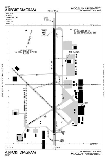
(KMCC) Mc Clellan Airfield
2 ratings | 4 reviews
Overview
Attendance:
Attended
Year-round, 7 Days a Week,All
FAA
Elevation:
77 ft (Surveyed)
Tower:
No
Airspace:
E
Fees:
Hangar, Landing, Ramp, Tie Down, Other
Click FBO link(s) below for details:
Click FBO link(s) below for details:
FBO Fee Details:
McClellan Jet ServicesTimezone:
PDT (UTC-07:00)
Sunrise-Sunset:
5:57 am - 8:09 pm
Evening-Morning Civil Twilight:
8:38 pm
(Today)
(Today)
-
5:26 am
(Tomorrow)
(Tomorrow)
Minimum Fuel Prices:
$6.42
100LL (full)
$5.42
100LL (self)
$6.25
Jet-A (full)
$6.30
Jet-A-Premix/Prist (full)
Runway
Satellite
Sectional
FBOs
Submit New FBO
McClellan Jet Services
4 ratings | 6 reviews
Services Offered:
Car Rental
$6.42 | 100LL | full
$5.42 | 100LL | self
$6.25 | Jet-A | full
$6.30 | Jet-A-Premix/Prist | full
Location:
On field: E
Phone:
(916) 641-8970
Freq. Monitored:
UNICOM: 122.975
Fees:
Hangar, Landing, Ramp, Tie Down, Other
Flight Training
Submit New Flight School
Other businesses
Submit New Business
AOPA Travel Discounts 
FlightBridge is the ultimate all-in-one travel booking platform built for the general aviation community. AOPA Members receive free access to FlightBridge with AOPA discounted rates automatically applied. Members save an average of 30% on hotel bookings! Learn more about FlightBridge HERE.
Local Food/Lodging/Activities
Local Attractions
Local Activities
Restaurants
Hotels and Lodging
Travel Discounts
Flying Clubs
Submit New Flying Club
Runway 16/34
Dimensions:
10,599 × 150 ft
(3,231 × 46 m)
(3,231 × 46 m)
Weight Bearing Cap:
Single wheel: 155,000 lbs
Double wheel: 300,000 lbs
Double tandem: 500,000 lbs
Double wheel: 300,000 lbs
Double tandem: 500,000 lbs
Surface:
concrete, grooved, in good condition
Runway Edge Lights:
High
Comments:
Nstd HIRL Lctd 25 Ft Fm Ry Edge Markings.
FAA
| Designator: | 16 | 34 |
| Elevation: | 76.8 ft | 69.9 ft |
| Heading: | 163° magnetic 180° true | -17° magnetic 000° true |
| Gradient: | 0.07% down | 0.07% up |
| Traffic Pattern: | Right Pattern | Left Pattern |
| Markings: | precision, in Good condition | precision, in Good condition |
| Approach Lighting: |
|
|
| Displaced Threshold: | n/a | n/a |
| ILS/LOC: | ILS | ILS |
| Obstructions: | n/a | Tower, 175 ft Left ft of center, 90 ft high, 4,000 ft from end, 42:1 clearance slope |
| Comments: | n/a | n/a |
Helipad H1
Dimensions:
57 × 57 ft
(17 × 17 m)
(17 × 17 m)
Weight Bearing Cap:
n/a
Surface:
concrete, no surface treatment, condition not reported
Runway Edge Lights:
n/a
Comments:
n/a
| Designator: | H1 |
| Elevation: | 76 ft |
| Markings: | non-standard |
| Obstructions: | n/a |
| Comments: | Military Markings on Airfield. FAA |
Helipad H2
Dimensions:
57 × 57 ft
(17 × 17 m)
(17 × 17 m)
Weight Bearing Cap:
n/a
Surface:
concrete, no surface treatment, condition not reported
Runway Edge Lights:
n/a
Comments:
n/a
| Designator: | H2 |
| Elevation: | 67 ft |
| Markings: | n/a |
| Obstructions: | n/a |
| Comments: | n/a |
Helipad H3
Dimensions:
57 × 57 ft
(17 × 17 m)
(17 × 17 m)
Weight Bearing Cap:
n/a
Surface:
asphalt, no surface treatment, condition not reported
Runway Edge Lights:
n/a
Comments:
n/a
| Designator: | H3 |
| Elevation: | 67 ft |
| Markings: | n/a |
| Obstructions: | n/a |
| Comments: | n/a |
Helipad H4
Dimensions:
57 × 57 ft
(17 × 17 m)
(17 × 17 m)
Weight Bearing Cap:
n/a
Surface:
concrete, no surface treatment, condition not reported
Runway Edge Lights:
n/a
Comments:
n/a
| Designator: | H4 |
| Elevation: | 68 ft |
| Markings: | n/a |
| Obstructions: | n/a |
| Comments: | n/a |
TFRs
Location: MCC
Please verify all content below using the FAA TFR Search Site or with a flight briefer.
TFR count: 0
NOTAMs
Location: MCC
Please verify all content below using the FAA NOTAM Search Site or with a flight briefer.
NOTAM count: 7
| Number: | Start Date: (UTC) | End Date: (UTC) | Condition: |
|---|---|---|---|
| 03/011 | 03/17/2020 1826 | TWY J CLSD | |
| 05/005 | 05/12/2025 1500 | 05/18/2025 0100 | SVC TEMPO TWR LOCAL CTL 133.15, GND CTL 135.45 DLY 1500-0100 |
| 03/015 | 03/31/2025 2201 | 05/31/2025 2300 | AD AP ABN U/S |
| 04/009 | 04/25/2025 1945 | 05/31/2025 2300 | APRON HELIPAD H2 CLSD |
| 01/003 | 01/12/2018 2036 | TWY K HELIPAD CLSD | |
| 02/030 | 02/28/2020 1350 | OBST TOWER LGT (ASR UNKNOWN) 383927.60N1212518.40W (1.1NM W MCC) 130FT (68.9FT AGL) U/S | |
| 05/006 | 05/15/2025 1600 | 05/25/2025 0300 | AIRSPACE NUMEROUS ACFT WI AN AREA DEFINED AS 7NM RADIUS OF 384409N1210725W (6.7NM NW O61) SFC-1500FT THU FRI… |
Additional Remarks
900 Ft Asph Ovrn Southeast End Ry 16 & 1000 Ft Asph Ovrn Northwest End Ry 34.
Source:
FAA
Federal Aviation Administration
All Acft Exit Ry to the East. Self Srv 100LL W Side Tw Kilo.
Source:
FAA
Federal Aviation Administration
Durg Increased Bird Conditions the Potential for Bird Congestion Exist At Both Arr/Dep Ends Ry 16/34.
Source:
FAA
Federal Aviation Administration
Field Conds-Rwy, Twy & Apron Good.
Source:
FAA
Federal Aviation Administration
For Clearance Delivery Contact Norcal Approach at 916-361-6874.
Source:
FAA
Federal Aviation Administration
Military Use: Tran Acft Prior Permission Required for Uscg Ramp C916-643-7659, with Crew List for Arr/Dep Pax.
Source:
FAA
Federal Aviation Administration
Military Use: Fuel - A+ (Mcclellan Jet Svc, C916-641-8970.)
Source:
FAA
Federal Aviation Administration
Ry 16 Calm Wind Rwy.
Source:
FAA
Federal Aviation Administration
Strict Adherence to Publd Tfc Pats Rcmd for Noise Abatement Purposes.
Source:
FAA
Federal Aviation Administration
Touch/Go Lndg for C5 Prohibited.
Source:
FAA
Federal Aviation Administration
Twys E,F,G Nstd Twy Edge Lgtg.
Source:
FAA
Federal Aviation Administration
Noise Abatement
Instrument Procedures
Data Cycle:
Operations & More Information
Lat/Long:
- 38.66764, -121.40061
- 38° 40′ 3.5″ N, 121° 24′ 2.2″ W
- 38° 40.058′ N, 121° 24.037′ W
ARTCC:
Oakland (ZOA)
App/Depart Control Facility:
NCT
Chart:
NACO: San Francisco Sectional
FSS:
Rancho Murieta (RIU)
1-800-WX-BRIEF
1-800-WX-BRIEF
Wind Indicator:
Yes
Mag Var:
17E (1975)
NOTAM Facility:
Seg Circle:
Yes
Beacon:
Present
Lighting:
Pilot Activated Lighting:
- low intensity: 3 clicks in 5 secs
- medium intensity: 5 clicks in 5 secs
- high intensity: 7 clicks in 5 secs
AM
Actvt MALSR Rwy 16; HIRL Rwy 16/34; Twy Lgts - CTAF. PAPI Rwys 16 & 34 Opr Consly.
FAA
Pattern Altitude:
TPA: 1076 Ft AGL
FAA
Special Operations:
Helicopter Ops
FAA
Communications Card
| Type: | Frequency / Phone: | Sector / Comments: | Call Sign: |
|---|---|---|---|
| Approach/Departure | 127.4 | Norcal | |
| AWOS-3 | 125.975T (916) 641-1272 | ||
| Clearance Delivery | 119.825 | Norcal | |
| Clearance Delivery Phone | (916) 361-6874 | Norcal Approach | |
| CTAF | 122.975 | ||
| UNICOM | 122.975 |
Navaids
Services
Fuel:
100LL Low-Lead, Jet A
AM
Engine Repair:
Major
AM
Airframe Repair:
Major
AM
Bottled Oxygen:
None
Bulk Oxygen:
High/Low
AM
Customs:
International Landing Rights
AM
Transportation:
None Reported
AM
Activities:
None Reported
Camping On Field:
None Reported
Aircraft & Activity
Webcams
METARs
TAFs
Contact Addresses
Airport Manager
Joshua Henry
McClellan, CA 95652-2502
(916) 570-5317 (Office)
Owner
Mc Clellan Business Park, LLC
McClellan, CA 95652-2502
(916) 570-5317 (Office)
Airport Reviews
Overall:
2 ratings | 4 reviews
Runways and Taxiways:
Markings and Signage:
Ground Transportation:
Sort By:
- 7/10/23Single engine piston friendlyMichael M.Made a trip up to Sacramento for the weekend, and it seemed like the area airports are more oriented to Jet traffic. But the fees were minimal, or none at all with fuel purchase, at McClellan Jet Services (see my review of them also). And they have…
- 9/21/22First time, but not the lastGeorge W.First time to KMCC. There was a temporary tower in place due to wildfire activity. Runway, etc., in good shape. Maybe I missed the signs but it was a bit confusing turning off the taxiway to the FBO, we turned too early but didn't have an issue in t…
- 7/14/17SHAWN H.We diverted here and were met by a wonderful desk crew at the Jet Services. They were very accommodating and got our overnight itinerary and transportation details worked out very quickly and efficiently. A great experience.
- 11/4/16RUSSELL E.ILS, long runway, 24 hour support, courtesy car, friendly people; a definite refuel stop when in the Sacramento area.