FAA Information Effective: May 15, 2025
All information is provided from the FAA unless otherwise noted.
(KTTA) Raleigh Exec Jetport At Sanford-Lee County Airport
2 ratings | 2 reviews
Overview
Attendance:
Attended
Year-round, 7 Days a Week,0800-1800
FAA
Runways:
03/21
Runway length: 6,501 ft (1,982 m)
Elevation:
247 ft (Surveyed)
Tower:
No
Airspace:
Unknown
Fees:
Hangar, Landing, Parking, Tie Down, Other
Click FBO link(s) below for details:
Click FBO link(s) below for details:
FBO Fee Details:
Raleigh Executive JetportTimezone:
EDT (UTC-04:00)
Sunrise-Sunset:
6:03 am - 8:27 pm
Evening-Morning Civil Twilight:
8:56 pm
(Today)
(Today)
-
5:34 am
(Tomorrow)
(Tomorrow)
Minimum Fuel Prices:
$6.02
100LL (full)
$5.42
100LL (self)
$4.94
Jet-A-Premix/Prist (full)
Runway
Satellite
Sectional
FBOs
Submit New FBO
Raleigh Executive Jetport
1 rating | 1 review
Services Offered:
Car Rental
$6.02 | 100LL | full
$5.42 | 100LL | self
$4.94 | Jet-A-Premix/Prist | full
Location:
On field: S
Phone:
(919) 776-2939
Freq. Monitored:
UNICOM: 123.075
Fees:
Hangar, Landing, Parking, Tie Down, Other
Flight Training
Submit New Flight School
Other businesses
Submit New Business
AOPA Travel Discounts 
FlightBridge is the ultimate all-in-one travel booking platform built for the general aviation community. AOPA Members receive free access to FlightBridge with AOPA discounted rates automatically applied. Members save an average of 30% on hotel bookings! Learn more about FlightBridge HERE.
Local Food/Lodging/Activities
Local Attractions
Local Activities
Restaurants
Hotels and Lodging
Travel Discounts
Flying Clubs
Submit New Flying Club
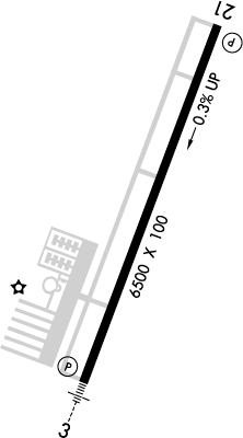
Runway 03/21
Dimensions:
6,501 × 100 ft
(1,982 × 30 m)
(1,982 × 30 m)
Weight Bearing Cap:
Single wheel: 30,000 lbs
Double wheel: 100,000 lbs
Double wheel: 100,000 lbs
Surface:
asphalt, no surface treatment, in excellent condition
Runway Edge Lights:
High
Comments:
n/a
| Designator: | 03 | 21 |
| Elevation: | 246.5 ft | 224.2 ft |
| Heading: | 029° magnetic 021° true | 209° magnetic 201° true |
| Gradient: | 0.34% down | 0.34% up |
| Traffic Pattern: | Not provided. Assume LEFT traffic pattern | Not provided. Assume LEFT traffic pattern |
| Markings: | precision, in Good condition | non-precision, in Good condition |
| Approach Lighting: |
|
|
| Displaced Threshold: | n/a | n/a |
| ILS/LOC: | ILS/DME | n/a |
| Obstructions: | Trees, 174 ft Right ft of center, 58 ft high, 2,493 ft from end, 39:1 clearance slope | Trees, 142 ft Left ft of center, 71 ft high, 2,194 ft from end, 28:1 clearance slope |
| Comments: | n/a | n/a |
TFRs
Location: TTA
Please verify all content below using the FAA TFR Search Site or with a flight briefer.
TFR count: 0
NOTAMs
Location: TTA
Please verify all content below using the FAA NOTAM Search Site or with a flight briefer.
NOTAM count: 7
| Number: | Start Date: (UTC) | End Date: (UTC) | Condition: |
|---|---|---|---|
| 04/022 | 04/28/2025 1100 | 06/13/2025 0001 | NAV ILS RWY 03 U/S |
| 3/9990 | 09/14/2023 1047 | IAP RALEIGH EXEC JETPORT AT SANFORD-LEE COUNTY, SANFORD, NC.
ILS Y OR LOC Y RWY 3, ORIG-B...
ILS DME RESTRIC… | |
| 05/005 | 05/15/2025 1150 | 09/12/2025 1150 | OBST TOWER LGT (ASR 1004943) 354409.00N0790935.00W (9.6NM NNW TTA) 1020.7FT (414.7FT AGL) U/S |
| 05/009 | 05/22/2025 0143 | 09/19/2025 0143 | OBST TOWER LGT (ASR 1004972) 353836.70N0790040.10W (5.8NM NE TTA) 556.1FT (304.1FT AGL) U/S |
| 05/018 | 05/30/2025 1954 | 06/23/2025 1200 | RWY 21 THR DISPLACED 986FT. DECLARED DIST: TORA 5514FT TODA 5514FT ASDA 5514FT LDA 5514FT. |
| 05/017 | 05/30/2025 1954 | 06/23/2025 1200 | RWY 03 DECLARED DIST: TORA 5114FT TODA 5114FT ASDA 5114FT LDA 5114FT. |
| 05/011 | 05/29/2025 0447 | 06/13/2025 0347 | OBST TOWER LGT (ASR 1238110) 353043.90N0785839.80W (7.3NM SE TTA) 2147.0FT (1747.0FT AGL) U/S |
Additional Remarks
For Clearance Delivery Contact Raleigh Approach at 919-380-3144.
Source:
FAA
Federal Aviation Administration
Twy A 15-30 Ft Drop-Off In vicinity of Twys A3 and A4.
Source:
FAA
Federal Aviation Administration
Use Rwy 03 for Calm Wind Rwy.
Source:
FAA
Federal Aviation Administration
Noise Abatement
Instrument Procedures
Data Cycle:
Operations & More Information
Lat/Long:
- 35.58244, -79.10134
- 35° 34′ 56.8″ N, 79° 6′ 4.8″ W
- 35° 34.946′ N, 79° 6.080′ W
ARTCC:
Washington (ZDC)
App/Depart Control Facility:
RDU
Chart:
NACO: Charlotte Sectional
FSS:
Raleigh (RDU)
1-800-WX-BRIEF
1-800-WX-BRIEF
Wind Indicator:
Lighted
Mag Var:
08W (2000)
NOTAM Facility:
Seg Circle:
Yes
Beacon:
Present
Lighting:
Pilot Activated Lighting:
- low intensity: 3 clicks in 5 secs
- medium intensity: 5 clicks in 5 secs
- high intensity: 7 clicks in 5 secs
AM
Dusk-Dawn. Actvt MALSR Rwy 03; REIL Rwy 21; HIRL Rwy 03/21 - CTAF. PAPI Rwys 03 & 21 on Consly.
FAA
Pattern Altitude:
No data provided. Assume 1000 AGL.
Special Operations:
Communications Card
| Type: | Frequency / Phone: | Sector / Comments: | Call Sign: |
|---|---|---|---|
| Approach/Departure | 125.3 | Raleigh | |
| AWOS-3 | 120.625T (919) 708-5382 | ||
| Clearance Delivery Phone | (919) 380-3144 | Raleigh Approach | |
| CTAF | 123.075 | ||
| UNICOM | 123.075 |
Navaids
Services
Fuel:
100LL Low-Lead, Jet A1 +Icing Inhibitor
AM
Engine Repair:
Major
AM
Airframe Repair:
Major
AM
Bottled Oxygen:
High
AM
Bulk Oxygen:
None
Customs:
None
Transportation:
None Reported
AM
Activities:
None Reported
Camping On Field:
None Reported
Aircraft & Activity
Webcams
METARs
TAFs
Contact Addresses
Airport Manager
Bob Heuts
Sanford, NC 27330
(919) 776-2939 (Office)
Owner
Sanford-Lee County Regional Airport Authority
Sanford, NC 27330
(919) 776-2939 (Office)
Airport Reviews
Overall:
2 ratings | 2 reviews
Runways and Taxiways:No ratings
Markings and Signage:No ratings
Ground Transportation:No ratings
Sort By:
- 6/5/21Zsolt P.Excellent facilities, new terminal/FBO building. Friendly staff. Great community there. Well maintained runway and taxiways.
- 7/5/19Joe R.The main FBO is under construction, but the temporary modular building works just fine. I stayed there for 5 days, and the weekly rental for a tie-down was only $15. It's a short Uber ride to KRDU. Nice! Folks there are friendly, with some helpfu…