FAA Information Effective: May 15, 2025
All information is provided from the FAA unless otherwise noted.
(KLNS) Lancaster Airport
1 rating | 3 reviews
Overview
Attendance:
Attended
Year-round,Mon-Fri/0600-2100
FAA
Year-round,Sat/0600-1800
FAA
Year-round,Sun/0800-2100
FAA
Elevation:
403 ft (Surveyed)
Tower:
Tower Hrs: 0600-2300
FAA
Airspace:
CLASS D SVC 0600-2300; OTHER TIMES CLASS E
FAA
Fees:
Timezone:
EDT (UTC-04:00)
Sunrise-Sunset:
5:49 am - 8:15 pm
Evening-Morning Civil Twilight:
8:46 pm
(Today)
(Today)
-
5:18 am
(Tomorrow)
(Tomorrow)
Minimum Fuel Prices:
$6.49
100LL (full)
$6.19
100LL (self)
$6.59
Jet-A (full)
$6.69
Jet-A-Premix/Prist (full)
Runway
Satellite
Sectional
FBOs
Submit New FBO
Alliance Aviation
3 ratings | 4 reviews
Services Offered:
Car Rental
$6.49 | 100LL | full
$6.19 | 100LL | self
$6.59 | Jet-A | full
$6.69 | Jet-A-Premix/Prist | full
Location:
On field: SE
Phone:
(717) 735-9507
Freq. Monitored:
UNICOM: 122.95
Fees:
Overnight, Ramp, Other
Flight Training
Submit New Flight School

Other businesses
Submit New Business
AOPA Travel Discounts 
FlightBridge is the ultimate all-in-one travel booking platform built for the general aviation community. AOPA Members receive free access to FlightBridge with AOPA discounted rates automatically applied. Members save an average of 30% on hotel bookings! Learn more about FlightBridge HERE.
Local Food/Lodging/Activities
Local Attractions
Local Activities
Restaurants
Hotels and Lodging
Travel Discounts
500 Airport Rd, Lititz, PA 17543
(717) 569-6732
543 Airport Rd, Lititz, PA 17543
(717) 517-8288
541 Airport Rd, Lititz, PA 17543
(717) 626-7720
LNS
Fiorentino's Bar & Grill bldg
Mick's All American Pub
Penn Cinema
Flying Clubs
Submit New Flying Club
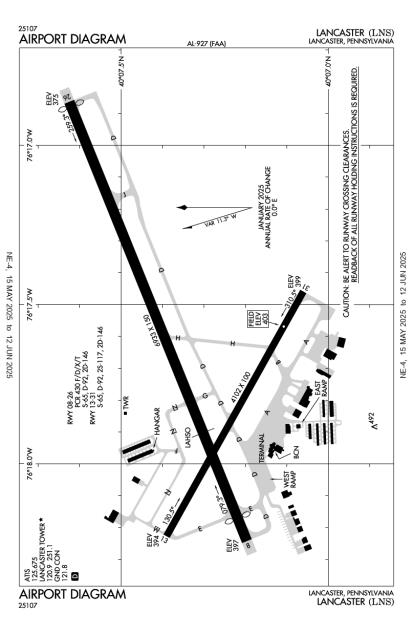
Runway 08/26
Dimensions:
6,933 × 150 ft
(2,113 × 46 m)
(2,113 × 46 m)
Weight Bearing Cap:
Single wheel: 65,000 lbs
Double wheel: 92,000 lbs
Double tandem: 146,000 lbs
Double wheel: 92,000 lbs
Double tandem: 146,000 lbs
Surface:
asphalt, grooved, in good condition
Runway Edge Lights:
High
Comments:
Pcr Value: 430/F/D/X/T
FAA
| Designator: | 08 | 26 |
| Elevation: | 396.8 ft | 374.7 ft |
| Heading: | 077° magnetic 068° true | 257° magnetic 248° true |
| Gradient: | 0.32% down | 0.32% up |
| Traffic Pattern: | Left Pattern | Left Pattern |
| Markings: | precision, in Good condition | non-precision, in Good condition |
| Approach Lighting: |
|
|
| Displaced Threshold: | 357 ft | 59 ft |
| ILS/LOC: | ILS | n/a |
| Obstructions: | Road, 380 ft Left ft of center, 5 ft high, 297 ft from end, 20:1 clearance slope | Tree, 276 ft Right ft of center, 40 ft high, 1,266 ft from end, 27:1 clearance slope |
| Comments: | Rwy 08 Approach Ratio 50:1 to Dthr. FAA | Rwy 26 Approach Ratio 34:1 to Dthr. FAA |
Runway 13/31
Dimensions:
4,102 × 100 ft
(1,250 × 30 m)
(1,250 × 30 m)
Weight Bearing Cap:
Single wheel: 65,000 lbs
Double wheel: 92,000 lbs
Double tandem: 146,000 lbs
Double wheel: 92,000 lbs
Double tandem: 146,000 lbs
Surface:
asphalt, no surface treatment, in good condition
Runway Edge Lights:
Medium
Comments:
n/a
| Designator: | 13 | 31 |
| Elevation: | 393.5 ft | 398.9 ft |
| Heading: | 128° magnetic 119° true | 308° magnetic 299° true |
| Gradient: | 0.13% up | 0.13% down |
| Traffic Pattern: | Left Pattern | Left Pattern |
| Markings: | non-precision, in Good condition | non-precision, in Good condition |
| Approach Lighting: |
|
|
| Displaced Threshold: | n/a | n/a |
| ILS/LOC: | n/a | n/a |
| Obstructions: | Tree, 477 ft Left ft of center, 76 ft high, 1,816 ft from end, 21:1 clearance slope | Trees, 330 ft Left ft of center, 25 ft high, 958 ft from end, 30:1 clearance slope |
| Comments: | Vgsi and Glidepath not Coincident. FAA | Rwy 31 Has 6 Ft Shrubs 58 Ft Fm Rwy End, 204 Ft Right. FAA |
TFRs
Location: LNS
Please verify all content below using the FAA TFR Search Site or with a flight briefer.
TFR count: 0
NOTAMs
Location: LNS
Please verify all content below using the FAA NOTAM Search Site or with a flight briefer.
NOTAM count: 5
| Number: | Start Date: (UTC) | End Date: (UTC) | Condition: |
|---|---|---|---|
| 04/011 | 04/16/2025 0437 | 05/31/2025 0435 | OBST TOWER LGT (ASN UNKNOWN) 401056.00N0760828.00W (7.9NM ENE LNS) 956.0FT (356.0FT AGL) U/S |
| 05/016 | 05/16/2025 1830 | 05/17/2025 1830 | APRON WEST RAMP CLSD |
| 3/2793 | 10/27/2023 1505 | IAP LANCASTER, LANCASTER, PA.
ILS OR LOC RWY 8, AMDT 2C...
VOR RWY 31, AMDT 16B...
VOR RWY 8, AMDT 21B...
VO… | |
| 03/002 | 03/01/2025 2225 | 05/30/2025 0500 | OBST TOWER LGT (ASR 1065558) 400959.50N0761921.40W (2.9NM NNW LNS) 607.9FT (196.9FT AGL) U/S |
| 02/139 | 02/21/2025 1616 | 06/21/2025 1616 | OBST TOWER LGT (ASR 1024577) 400802.30N0761257.20W (3.7NM E LNS) 616.1FT (270.0FT AGL) U/S |
Additional Remarks
For Cd When Air Traffic Control Tower Clsd, CTC Harrisburg Approach at 800-932-0712.
Source:
FAA
Federal Aviation Administration
Rwy Lgts and MALSR Unmonitored When Twr Clsd.
Source:
FAA
Federal Aviation Administration
Rwy/Twy Conditions not Monitored Outside of Attendance Hours.
Source:
FAA
Federal Aviation Administration
Ppr 24 Hrs for Acr Operations with More Than 30 Psgr Seats; Call Airport Manager (717) 569-1221.
Source:
FAA
Federal Aviation Administration
Noise Abatement
Instrument Procedures
Data Cycle:
Operations & More Information
Lat/Long:
- 40.12236, -76.29436
- 40° 7′ 20.5″ N, 76° 17′ 39.7″ W
- 40° 7.342′ N, 76° 17.662′ W
ARTCC:
New York (ZNY)
App/Depart Control Facility:
MDT
Chart:
NACO: New York Sectional
FSS:
Williamsport (IPT)
1-800-WX-BRIEF
1-800-WX-BRIEF
Wind Indicator:
Lighted
Mag Var:
09W (1965)
NOTAM Facility:
Seg Circle:
No
Beacon:
Present
Lighting:
Pilot Activated Lighting:
- medium intensity: 3 clicks in 5 secs
AM
When Air Traffic Control Tower Clsd Actvt MALSR Rwy 08; REIL Rwy 31; HIRL 08/26; MIRL Rwy 13/31; Twy Lgts - CTAF.
FAA
Pattern Altitude:
No data provided. Assume 1000 AGL.
Special Operations:
Communications Card
| Type: | Frequency / Phone: | Sector / Comments: | Call Sign: |
|---|---|---|---|
| Approach/Departure | 126.45 | Harrisburg | |
| ASOS | 125.675T (717) 569-8860 | Lancaster | |
| ATIS | 125.675 | Lancaster | |
| CTAF | 120.9 | Lancaster | |
| Emergency | 121.5 | Lancaster | |
| Ground Control | 121.8 | Lancaster | |
| Tower | 120.9 | Lancaster | |
| UNICOM | 122.95 | Lancaster |
Navaids
Services
Fuel:
100LL Low-Lead, Jet A
AM
Engine Repair:
Major
AM
Airframe Repair:
Major
AM
Bottled Oxygen:
Low
AM
Bulk Oxygen:
None
Customs:
None
Transportation:
Courtesy Transportation
AM
Activities:
Intensive Flight Training, On field restaurant/café
AM
Camping On Field:
None Reported
Aircraft & Activity
Webcams
METARs
TAFs
Contact Addresses
Airport Manager
Ed Foster
Lititz, PA 17543-9340
(717) 569-1221 (Office)
Owner
Lancaster Airport Authority
Lititz, PA 17543-9340
(717) 569-1221 (Office)
Airport Reviews
Overall:
1 rating | 3 reviews
Runways and Taxiways:No ratings
Markings and Signage:No ratings
Ground Transportation:No ratings
Sort By:
- 8/6/19Donald T.These people are the best, have been going into LNS for the last 10 yrs and find them to be extremely accommodating. If in the area, don't hesitate to stop.
- 11/21/18Marlin D.KLNS is my home airport and has been since I began flying years ago I can't say enough good things about them. the FBO staff and controllers are awesome. Two runways and a host of varied approaches make practice enjoyable and wind conditions manageab…
- 1/15/16JONG L.Alliance Aviation: very nice front desk staff and line service was efficient. Facilities were clean and well maintained. Pilot lounge had a computer. Nothing looked like an after thought, overall very professional impression. Tower staff was also ver…