FAA Information Effective: Apr 17, 2025
All information is provided from the FAA unless otherwise noted.
(KHLX) Twin County Airport
2 ratings | 3 reviews
Overview
Attendance:
Attended
Aft Hrs Trml Access Avbl S Side of Bldg.
FAA
Unattended New Year's Day, Easter, Thanksgiving, & Christmas.
FAA
Year-round,M-F/0800-1700
FAA
Runways:
01/19
Runway length: 4,151 ft (1,265 m)
Elevation:
2,694 ft (Surveyed)
Tower:
No
Airspace:
Unknown
Fees:
Overnight, Ramp, Other
Click FBO link(s) below for details:
Click FBO link(s) below for details:
FBO Fee Details:
Twin County Airport CommissionTimezone:
EDT (UTC-04:00)
Sunrise-Sunset:
6:19 am - 8:22 pm
Evening-Morning Civil Twilight:
8:51 pm
(Today)
(Today)
-
5:49 am
(Tomorrow)
(Tomorrow)
Minimum Fuel Prices:
$5.20
100LL (self)
$5.15
Jet-A-Premix/Prist (self)
Runway
Satellite
Sectional
FBOs
Submit New FBO
Twin County Airport Commission
1 rating | 1 review
Services Offered:
Car Rental
$5.20 | 100LL | self
$5.15 | Jet-A-Premix/Prist | self
Location:
On field: CTR
Phone:
(276) 728-4504
Freq. Monitored:
Fees:
Overnight, Ramp, Other
Flight Training
Submit New Flight School
Other businesses
Submit New Business
AOPA Travel Discounts 
FlightBridge is the ultimate all-in-one travel booking platform built for the general aviation community. AOPA Members receive free access to FlightBridge with AOPA discounted rates automatically applied. Members save an average of 30% on hotel bookings! Learn more about FlightBridge HERE.
Local Food/Lodging/Activities
Local Attractions
Local Activities
Restaurants
Hotels and Lodging
Travel Discounts
Flying Clubs
Submit New Flying Club
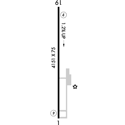
Runway 01/19
Dimensions:
4,151 × 75 ft
(1,265 × 23 m)
(1,265 × 23 m)
Weight Bearing Cap:
Single wheel: 13,000 lbs
Surface:
asphalt, no surface treatment, in fair condition
Runway Edge Lights:
Medium
Comments:
n/a
| Designator: | 01 | 19 |
| Elevation: | 2,693.1 ft | 2,642.6 ft |
| Heading: | 367° magnetic 359° true | 187° magnetic 179° true |
| Gradient: | 1.22% down | 1.22% up |
| Traffic Pattern: | Left Pattern | Left Pattern |
| Markings: | non-precision, in Good condition | non-precision, in Good condition |
| Approach Lighting: |
|
|
| Displaced Threshold: | n/a | n/a |
| ILS/LOC: | n/a | n/a |
| Obstructions: | Trees, 355 ft Left ft of center, 41 ft high, 985 ft from end, 19:1 clearance slope | Trees, 63 ft Right ft of center, 54 ft high, 1,237 ft from end, 19:1 clearance slope |
| Comments: | Rwy 01 Has 10-20 Ft Hill Lctd 150 Ft W of Rwy 01, Beginning N of Thld. FAA | Rwy Mrkg Conds Vary Btwn Good & Fair. Rwy Displacement Mrkg Incorrect. FAA |
TFRs
Location: HLX
Please verify all content below using the FAA TFR Search Site or with a flight briefer.
TFR count: 0
NOTAMs
Location: HLX
Please verify all content below using the FAA NOTAM Search Site or with a flight briefer.
NOTAM count: 4
| Number: | Start Date: (UTC) | End Date: (UTC) | Condition: |
|---|---|---|---|
| 05/002 | 05/08/2025 1036 | 06/05/2025 2000 | SVC AUTOMATED WX BCST SYSTEM U/S |
| 04/001 | 04/24/2025 0433 | 06/23/2025 2359 | OBST TOWER LGT (ASR 1234417) 364107.90N0805102.70W (5.0NM SSW HLX) 3155.8FT (239.8FT AGL) U/S |
| 03/002 | 03/12/2025 0406 | 05/31/2025 2359 | OBST TOWER LGT (ASR 1241654) 363710.50N0810104.00W (13.0NM SW HLX) 2904.9FT (315.0FT AGL) U/S |
| 5/4147 | 01/16/2025 1510 | IAP TWIN COUNTY, GALAX HILLSVILLE, VA.
RNAV (GPS) RWY 19, AMDT 1B...
VGSI AND DESCENT ANGLES NOT COINCIDENT … | |
Additional Remarks
Deer on & In vicinity of Arpt.
Source:
FAA
Federal Aviation Administration
For Clearance Delivery Contact Roanoke Approach at 540-563-1307.
Source:
FAA
Federal Aviation Administration
Roa Twr Services Avbl At 540-563-1307.
Source:
FAA
Federal Aviation Administration
Rwy 01 10-20 Ft Hill Lctd 150 Ft W of Rwy 01 Beginning N of Thld.
Source:
FAA
Federal Aviation Administration
Noise Abatement
Instrument Procedures
Data Cycle:
Operations & More Information
Lat/Long:
- 36.76604, -80.82356
- 36° 45′ 57.7″ N, 80° 49′ 24.8″ W
- 36° 45.962′ N, 80° 49.414′ W
ARTCC:
Washington (ZDC)
App/Depart Control Facility:
ROA
Chart:
NACO: Cincinnati Sectional
FSS:
Leesburg (DCA)
1-800-WX-BRIEF
1-800-WX-BRIEF
Wind Indicator:
Lighted
Mag Var:
08W (2010)
NOTAM Facility:
Seg Circle:
No
Beacon:
Present
Lighting:
Actvt MIRL Rwy 1/19 - CTAF. REILs Rwy 1 & 19; PAPI Rwy 1 & 19 Operations Consly.
FAA
Pattern Altitude:
No data provided. Assume 1000 AGL.
Special Operations:
Communications Card
| Type: | Frequency / Phone: | Sector / Comments: | Call Sign: |
|---|---|---|---|
| Approach/Departure IC | 126.0 | Roanoke | |
| AWOS-3 | 118.375T (276) 728-5897 | ||
| Clearance Delivery Phone | (540) 563-1307 | Roanoke Approach | |
| CTAF | 122.8 | ||
| UNICOM | 122.8 |
Navaids
Services
Fuel:
100LL Low-Lead
AM
Engine Repair:
Major
AM
Airframe Repair:
Major
AM
Bottled Oxygen:
None
Bulk Oxygen:
None
Customs:
None
Transportation:
None Reported
AM
Activities:
None Reported
Camping On Field:
None Reported
Aircraft & Activity
Webcams
METARs
TAFs
Contact Addresses
Airport Manager
Michael Lawson
Hillsville, VA 24343-5264
(276) 728-4504 (Office)
Owner
Twin County Airport Comsn
Hillsville, VA 24343-5264
(276) 728-4504 (Office)
Remarks:
Fax 276-728-4544.
FAA
Airport Reviews
Overall:
2 ratings | 3 reviews
Runways and Taxiways:
Markings and Signage:
Ground Transportation:
Sort By:
- 1/25/21Paul K.Flew in on Sunday, 1/24/2021. KHLX is a cool airport to fly into. The visual slope of Rnwy19 is picturesque. Well run, super facilities, and great coffee. It’s a must stop. If you’re in transit and need a respite, I recommend KHLX Twin County. Guaran…
- 11/10/19Chief Dep. Richard Carter / Chambers County S.O.Richard C.On our way to Shenandoah, we stopped in to Twin County for fuel. Fulling expecting Self Serve, I was greeted by 3 gentleman who began to assist in everything but swiping my card. One turned out to be the Chairman of the Airport Authority if my memo…
- 6/30/14GARY W.Flew into Twin County 6/27/14 for a bathroom pit-stop and to evaluate weather while on the ground. They have a new terminal building which is very nice facility. The airport manager was very friendly, greeted us at the airplane, helped us with intern…