FAA Information Effective: Apr 17, 2025
All information is provided from the FAA unless otherwise noted.
(KGAD) Northeast Alabama Regional Airport
No ratings | 4 reviews
Overview
Attendance:
Attended
Year-round,Mon-Fri/0800-1800
FAA
Year-round,Sat/0900-1700
FAA
Elevation:
569 ft (Surveyed)
Tower:
No
Airspace:
Unknown
Fees:
Landing, Tie Down, Other
Click FBO link(s) below for details:
Click FBO link(s) below for details:
FBO Fee Details:
Northeast Alabama AviationTimezone:
CDT (UTC-05:00)
Sunrise-Sunset:
5:48 am - 7:36 pm
Evening-Morning Civil Twilight:
8:03 pm
(Today)
(Today)
-
5:19 am
(Tomorrow)
(Tomorrow)
Minimum Fuel Prices:
$5.75
100LL (full)
$5.50
100LL (self)
$5.75
Jet-A-Premix/Prist (full)
Runway
Satellite
Sectional
FBOs
Submit New FBO
Northeast Alabama Aviation
No ratings | Be the first to review this business
Services Offered:
Car Rental
$5.75 | 100LL | full
$5.50 | 100LL | self
$5.75 | Jet-A-Premix/Prist | full
Location:
On field: E
Phone:
(256) 442-3313
Freq. Monitored:
UNICOM: 122.8
Fees:
Landing, Tie Down, Other
Flight Training
Submit New Flight School
Other businesses
Submit New Business
AOPA Travel Discounts 
FlightBridge is the ultimate all-in-one travel booking platform built for the general aviation community. AOPA Members receive free access to FlightBridge with AOPA discounted rates automatically applied. Members save an average of 30% on hotel bookings! Learn more about FlightBridge HERE.
Local Food/Lodging/Activities
Local Attractions
Local Activities
Restaurants
Hotels and Lodging
Travel Discounts
(256) 538-9996
(256) 538-5938
(256) 570-0570
GAD
Noccalula Falls
Twin Bridges Golf Club
Historic Downtown Gadsden
Martin Wildlife Park
Ruby Tuesday
Cracker Barrel
Old Mexico Cantina
Flying Clubs
Submit New Flying Club
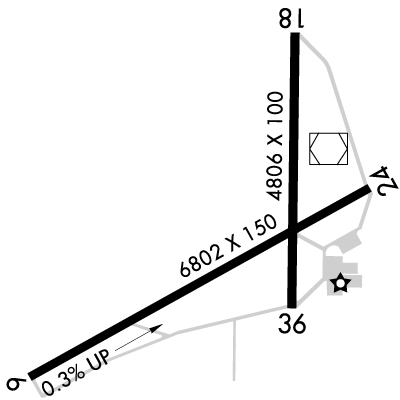
Runway 06/24
Dimensions:
6,802 × 150 ft
(2,073 × 46 m)
(2,073 × 46 m)
Weight Bearing Cap:
Single wheel: 90,000 lbs
Double wheel: 115,000 lbs
Double tandem: 195,000 lbs
Double wheel: 115,000 lbs
Double tandem: 195,000 lbs
Surface:
asphalt, grooved, in fair condition
Runway Edge Lights:
High
Comments:
n/a
| Designator: | 06 | 24 |
| Elevation: | 569.2 ft | 549.3 ft |
| Heading: | 064° magnetic 061° true | 244° magnetic 241° true |
| Gradient: | 0.29% down | 0.29% up |
| Traffic Pattern: | Left Pattern | Left Pattern |
| Markings: | precision, in Fair condition | precision, in Fair condition |
| Approach Lighting: |
|
|
| Displaced Threshold: | n/a | n/a |
| ILS/LOC: | n/a | ILS/DME |
| Obstructions: | Tree, 222 ft Right ft of center, 52 ft high, 1,621 ft from end, 27:1 clearance slope | Tree, 172 ft Left ft of center, 55 ft high, 2,724 ft from end, 45:1 clearance slope |
| Comments: | n/a | n/a |
Runway 18/36
Dimensions:
4,806 × 100 ft
(1,465 × 30 m)
(1,465 × 30 m)
Weight Bearing Cap:
Single wheel: 25,000 lbs
Double wheel: 40,000 lbs
Double tandem: 78,000 lbs
Double wheel: 40,000 lbs
Double tandem: 78,000 lbs
Surface:
asphalt, no surface treatment, in fair condition
Runway Edge Lights:
Medium
Comments:
n/a
| Designator: | 18 | 36 |
| Elevation: | 541.9 ft | 553 ft |
| Heading: | 183° magnetic 180° true | 003° magnetic 000° true |
| Gradient: | 0.23% up | 0.23% down |
| Traffic Pattern: | Left Pattern | Left Pattern |
| Markings: | non-precision, in Fair condition | non-precision, in Fair condition |
| Approach Lighting: |
|
|
| Displaced Threshold: | n/a | n/a |
| ILS/LOC: | n/a | n/a |
| Obstructions: | Tree, 105 ft Right ft of center, 27 ft high, 677 ft from end, 17:1 clearance slope | Tree, 127 ft Right ft of center, 67 ft high, 1,883 ft from end, 25:1 clearance slope |
| Comments: | Markings Faded. FAA | Markings Faded. FAA |
TFRs
Location: GAD
Please verify all content below using the FAA TFR Search Site or with a flight briefer.
TFR count: 0
NOTAMs
Location: GAD
Please verify all content below using the FAA NOTAM Search Site or with a flight briefer.
NOTAM count: 13 (Partial list shown. Expand to see full list HERE.)
| Number: | Start Date: (UTC) | End Date: (UTC) | Condition: |
|---|---|---|---|
| 4/5856 | 09/16/2024 1335 | IAP NORTHEAST ALABAMA RGNL, GADSDEN, AL.
RNAV (GPS) RWY 6, AMDT 1D...
VOR RWY 6, AMDT 14...
CIRCLING CAT B M… | |
| 10/013 | 10/17/2024 2217 | 06/12/2025 2359 | OBST TOWER (ASR UNKNOWN) 340156.28N0860417.76W (3.68NM NNE GAD) 1195FT (233FT AGL) LGTD NOT FLAGGED |
| 04/023 | 04/11/2025 2020 | 10/11/2025 2359 | RWY 36 PAPI UNUSABLE |
| 04/027 | 04/14/2025 2040 | 05/29/2025 2039 | OBST TOWER LGT (ASR 1208020) 340920.20N0855931.00W (12.1NM NNE GAD) 988.8FT (319.9FT AGL) U/S |
| 05/008 | 05/09/2025 0446 | 05/24/2025 0346 | OBST TOWER LGT (ASR 1218185) 335813.90N0860210.30W (2.6NM E GAD) 783.8FT (270.0FT AGL) U/S |
| 01/032 | 01/17/2025 1902 | 07/17/2025 2359 | RWY 18 PAPI UNUSABLE |
| 03/011 | 03/09/2025 0000 | 06/06/2025 0500 | OBST TOWER LGT (ASR 1231602) 335923.00N0855023.20W (12.5NM E GAD) 951.1FT (324.1FT AGL) U/S |
| 05/002 | 05/03/2025 0734 | 06/06/2025 2300 | OBST TOWER LGT (ASR 1050332) 335848.00N0860023.00W (4.2NM E GAD) 569.9FT (328.1FT AGL) U/S |
Additional Remarks
Noise Abatement
Instrument Procedures
Data Cycle:
Operations & More Information
Lat/Long:
- 33.97265, -86.08908
- 33° 58′ 21.5″ N, 86° 5′ 20.7″ W
- 33° 58.359′ N, 86° 5.345′ W
ARTCC:
Atlanta (ZTL)
App/Depart Control Facility:
BHM
Chart:
NACO: Atlanta Sectional
FSS:
Anniston (ANB)
1-800-WX-BRIEF
1-800-WX-BRIEF
Wind Indicator:
Lighted
Mag Var:
03W (2010)
NOTAM Facility:
Seg Circle:
Yes
Beacon:
Present
Lighting:
Actvt REIL Rwys 6 & 24; PAPI Rwys 6, 24, 18 & 36; HIRL Rwy 6/24; MIRL Rwy 18/36; Twy Lgts - CTAF.
FAA
Pattern Altitude:
No data provided. Assume 1000 AGL.
Special Operations:
Communications Card
| Type: | Frequency / Phone: | Sector / Comments: | Call Sign: |
|---|---|---|---|
| Approach/Departure | 125.45 | Birmingham | |
| AWOS-3PT | 127.825T (256) 442-7094 | ||
| Clearance Delivery | 120.05 | Birmingham | |
| CTAF | 122.8 | ||
| UNICOM | 122.8 |
Navaids
Services
Fuel:
100LL Low-Lead, Jet A1 +Icing Inhibitor
AM
Engine Repair:
Major
AM
Airframe Repair:
Major
AM
Bottled Oxygen:
None
Bulk Oxygen:
None
Customs:
None
Transportation:
Courtesy Transportation
AM
Activities:
Intensive Flight Training
AM
Camping On Field:
None Reported
Aircraft & Activity
Webcams
METARs
TAFs
Contact Addresses
Airport Manager
Anthony Tarver
Gadsden, AL 35904
(256) 328-4700 (Office)
Owner
Gadsden Airport Authority
Gadsden, AL 35904
(256) 442-3313 (Office)
Airport Reviews
Overall:
No ratings | 4 reviews
Runways and Taxiways:No ratings
Markings and Signage:No ratings
Ground Transportation:No ratings
Sort By:
- 9/2/18Roy T.Dropped in today for a quick break with my 3 flying passenger guests who had never flown in GA plane. Very friendly, chocked us up and nothing expected in return! Very nice FBO even has an inside balcony to see whole field that caught the attention…
- 10/9/16NICHOLAS J.Wonderful FBO, extremely friendly staff. We showed up unannounced and the two fellows worked quickly to get us set-up with a rental car. Perfect example of hospitality - free popcorn, great crow's nest view of the airfield. Would definitely recommend…
- 6/18/14ANTHONY B.We flew into KGAD from KHDC for a fuel stop wx did not cooperate for last leg of trip to KTRI .Decided to drive therefore the FBO staff took good care of us and plane located us a rental car and they hangared the plane @no charge!!!Great service!!!A …
- 4/13/13DANIEL M.We stopped for fuel and lunch at KGAD on 29 MAR 2013 and had a great experience. Great southern hospitality, good fuel price and just a friendly atmosphere. They have a courtesy car if you need it too (which we did not). This is a great place to stop…