FAA Information Effective: Apr 17, 2025
All information is provided from the FAA unless otherwise noted.
(KFST) Fort Stockton-Pecos County Airport
No ratings | 1 review
Fort Stockton, TX
(432) 336-6261
Overview
Attendance:
Attended
Year-round, 7 Days a Week,0800-1700
FAA
Elevation:
3,011 ft (Surveyed)
Tower:
No
Airspace:
Unknown
Fees:
Landing, Ramp, Tie Down, Other
Click FBO link(s) below for details:
Click FBO link(s) below for details:
FBO Fee Details:
Fort Stockton Aviation, LLCTimezone:
CDT (UTC-05:00)
Sunrise-Sunset:
7:11 am - 8:29 pm
Evening-Morning Civil Twilight:
8:54 pm
(Today)
(Today)
-
6:44 am
(Tomorrow)
(Tomorrow)
Minimum Fuel Prices:
$5.71
100LL (self)
$5.19
Jet-A-Premix/Prist (full)
$4.99
Jet-A-Premix/Prist (self)
Runway
Satellite
Sectional
FBOs
Submit New FBO
Fort Stockton Aviation, LLC
1 rating | 2 reviews
Services Offered:
$5.71 | 100LL | self
$5.19 | Jet-A-Premix/Prist | full
$4.99 | Jet-A-Premix/Prist | self
Location:
On field: S
Phone:
(432) 336-9900
Freq. Monitored:
UNICOM: 122.8
Fees:
Landing, Ramp, Tie Down, Other
Flight Training
Submit New Flight School
Other businesses
Submit New Business
AOPA Travel Discounts 
FlightBridge is the ultimate all-in-one travel booking platform built for the general aviation community. AOPA Members receive free access to FlightBridge with AOPA discounted rates automatically applied. Members save an average of 30% on hotel bookings! Learn more about FlightBridge HERE.
Local Food/Lodging/Activities
Local Attractions
Local Activities
Restaurants
Hotels and Lodging
Travel Discounts
(432) 336-3569
(432) 336-9600
(432) 336-7000
(432) 336-7700
FST
Pecos Roadhouse
Hampton Inn
Best Western Plus
Candlewood Suites
Flying Clubs
Submit New Flying Club
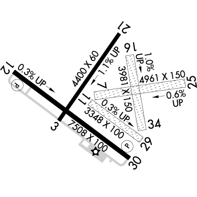
Runway 12/30
Dimensions:
7,508 × 100 ft
(2,288 × 30 m)
(2,288 × 30 m)
Weight Bearing Cap:
Single wheel: 24,000 lbs
Surface:
asphalt, no surface treatment, in good condition
Runway Edge Lights:
Medium
Comments:
n/a
| Designator: | 12 | 30 |
| Elevation: | 2,985.2 ft | 3,010.4 ft |
| Heading: | 118° magnetic 127° true | 298° magnetic 307° true |
| Gradient: | 0.34% up | 0.34% down |
| Traffic Pattern: | Left Pattern | Left Pattern |
| Markings: | non-precision, in Good condition | non-precision, in Good condition |
| Approach Lighting: |
|
|
| Displaced Threshold: | n/a | n/a |
| ILS/LOC: | n/a | n/a |
| Obstructions: | Tree, 165 ft Left ft of center, 20 ft high, 500 ft from end, 15:1 clearance slope | Road, Both-Sides, 10 ft high, 200 ft from end |
| Comments: | 5 Ft Fence, 0-199 Ft Dstc, 145 Ft L. FAA Unusbl Byd 8 Deg Right of Rcl. FAA | Gravel Road At 190 Ft Acrs Apch. FAA Unusbl Byd 8 Deg Right of Rcl. FAA |
Runway 07/25
Dimensions:
4,961 × 150 ft
(1,512 × 46 m)
(1,512 × 46 m)
Weight Bearing Cap:
n/a
Surface:
turf, grass, sod, no surface treatment, in poor condition
Runway Edge Lights:
n/a
Comments:
Rwy not Mkd - Rough with Thorns.
FAA
| Designator: | 07 | 25 |
| Elevation: | 2,994.1 ft | 2,965.6 ft |
| Heading: | 073° magnetic 082° true | 253° magnetic 262° true |
| Gradient: | 0.57% down | 0.57% up |
| Traffic Pattern: | Left Pattern | Left Pattern |
| Markings: | none, in Fair condition | none, in Fair condition |
| Approach Lighting: | n/a | n/a |
| Displaced Threshold: | n/a | n/a |
| ILS/LOC: | n/a | n/a |
| Obstructions: | n/a | Trees, 23 ft Left ft of center, 9 ft high, 186 ft from end, 20:1 clearance slope |
| Comments: | n/a | n/a |
Runway 03/21
Dimensions:
4,400 × 60 ft
(1,341 × 18 m)
(1,341 × 18 m)
Weight Bearing Cap:
n/a
Surface:
asphalt, no surface treatment, in fair condition
Runway Edge Lights:
Medium
Comments:
n/a
| Designator: | 03 | 21 |
| Elevation: | 3,006.7 ft | 2,956.7 ft |
| Heading: | 028° magnetic 037° true | 208° magnetic 217° true |
| Gradient: | 1.14% down | 1.14% up |
| Traffic Pattern: | Not provided. Assume LEFT traffic pattern | Not provided. Assume LEFT traffic pattern |
| Markings: | basic, in Fair condition | basic, in Fair condition |
| Approach Lighting: | n/a | n/a |
| Displaced Threshold: | n/a | n/a |
| ILS/LOC: | n/a | n/a |
| Obstructions: | Power-Line, Both-Sides, 110 ft high, 2,100 ft from end, 17:1 clearance slope | n/a |
| Comments: | n/a | n/a |
Runway 16/34
Dimensions:
3,981 × 150 ft
(1,213 × 46 m)
(1,213 × 46 m)
Weight Bearing Cap:
n/a
Surface:
turf, grass, sod, no surface treatment, in poor condition
Runway Edge Lights:
n/a
Comments:
Rwy not Mkd - Rough with Thorns.
FAA
| Designator: | 16 | 34 |
| Elevation: | 2,964.2 ft | 3,003.7 ft |
| Heading: | 162° magnetic 171° true | 342° magnetic 351° true |
| Gradient: | 0.99% up | 0.99% down |
| Traffic Pattern: | Not provided. Assume LEFT traffic pattern | Not provided. Assume LEFT traffic pattern |
| Markings: | none, in Fair condition | none, in Fair condition |
| Approach Lighting: | n/a | n/a |
| Displaced Threshold: | n/a | n/a |
| ILS/LOC: | n/a | n/a |
| Obstructions: | Brush, Both-Sides, 10 ft high | Tree, 148 ft Right ft of center, 75 ft high, 1,400 ft from end, 18:1 clearance slope |
| Comments: | 10 Ft Trees and Brush At Thr Acrs Apch. FAA | n/a |
Runway 11/29
Dimensions:
3,348 × 100 ft
(1,020 × 30 m)
(1,020 × 30 m)
Weight Bearing Cap:
n/a
Surface:
turf, grass, sod, no surface treatment, in poor condition
Runway Edge Lights:
n/a
Comments:
Rwy not Mkd - Rough with Thorns.
FAA
| Designator: | 11 | 29 |
| Elevation: | 2,995.5 ft | 3,005.4 ft |
| Heading: | 117° magnetic 126° true | 297° magnetic 306° true |
| Gradient: | 0.3% up | 0.3% down |
| Traffic Pattern: | Left Pattern | Left Pattern |
| Markings: | none, in Poor condition | none, in Poor condition |
| Approach Lighting: | n/a | n/a |
| Displaced Threshold: | n/a | n/a |
| ILS/LOC: | n/a | n/a |
| Obstructions: | n/a | Road, Both-Sides, 10 ft high, 65 ft from end, 6:1 clearance slope |
| Comments: | Thr not Mkd. FAA | Thr not Mkd. FAA |
TFRs
Location: FST
Please verify all content below using the FAA TFR Search Site or with a flight briefer.
TFR count: 0
NOTAMs
Location: FST
Please verify all content below using the FAA NOTAM Search Site or with a flight briefer.
NOTAM count: 3
| Number: | Start Date: (UTC) | End Date: (UTC) | Condition: |
|---|---|---|---|
| 04/005 | 04/22/2025 2214 | 05/07/2025 2114 | OBST TOWER LGT (ASR 1246848) 305212.30N1025321.30W (3.0NM SSE FST) 3290.7FT (291.0FT AGL) U/S |
| 04/008 | 04/28/2025 1501 | 05/02/2025 1500 | AD AP JET A FUEL NOT AVBL |
| 04/007 | 04/27/2025 0357 | 08/25/2025 0357 | OBST TOWER LGT (ASR 1049449) 305159.70N1024853.90W (5.9NM ESE FST) 3686.7FT (446.9FT AGL) U/S |
Additional Remarks
3210 Ft Twr 2 Mi Ne.
Source:
FAA
Federal Aviation Administration
For Cd If Una to CTC on FSS Freq, CTC Albuquerque ARTCC at 505-856-4561.
Source:
FAA
Federal Aviation Administration
Turf Rwy 7/25, 11/29,16/34 Rough. Rwy Ends 16 & 25 not Inspd Due to Field Conds.
Source:
FAA
Federal Aviation Administration
Noise Abatement
Instrument Procedures
Data Cycle:
Operations & More Information
Lat/Long:
- 30.91525, -102.91278
- 30° 54′ 54.9″ N, 102° 54′ 46.0″ W
- 30° 54.915′ N, 102° 54.767′ W
ARTCC:
Albuquerque (ZAB)
App/Depart Control Facility:
Unknown
Chart:
NACO: San Antonio Sectional
FSS:
San Angelo (SJT)
1-800-WX-BRIEF
1-800-WX-BRIEF
Wind Indicator:
Lighted
Mag Var:
09E (1995)
NOTAM Facility:
Seg Circle:
Yes
Beacon:
Present
Lighting:
Mirl Rwys 03/21 & 12/30 Preset Low Intst; to Incr Intst - CTAF. PAPI Rwys 12 & 30 Opr Consly.
FAA
Pattern Altitude:
No data provided. Assume 1000 AGL.
Special Operations:
Communications Card
| Type: | Frequency / Phone: | Sector / Comments: | Call Sign: |
|---|---|---|---|
| ASOS | 118.525T (432) 336-7591 | ||
| CTAF | 122.8 | ||
| UNICOM | 122.8 |
Navaids
Services
Fuel:
100LL Low-Lead
AM
Engine Repair:
None
Airframe Repair:
None
Bottled Oxygen:
None
Bulk Oxygen:
None
Customs:
None
Transportation:
Courtesy Transportation
AM
Activities:
None Reported
Camping On Field:
None Reported
Aircraft & Activity
Webcams
METARs
TAFs
Contact Addresses
Airport Manager
Tom Chapman
Fort Stockton, TX 79735
(432) 336-6261 (Office)
Owner
Pecos County
Fort Stockton, TX 79735
(432) 336-2792 (Office)
Remarks:
County Commissioner.
FAA
Airport Reviews
Overall:
No ratings | 1 review
Runways and Taxiways:No ratings
Markings and Signage:No ratings
Ground Transportation:No ratings
Sort By:
- 4/3/17MICHAEL G.Landed March 27, 2017 for fuel. John the manager, ably assisted me with the fueling. The airport has a number of WW II hangars that are still being used. The office is also of WWII vintage. No issues with this facility.