FAA Information Effective: Apr 17, 2025
All information is provided from the FAA unless otherwise noted.
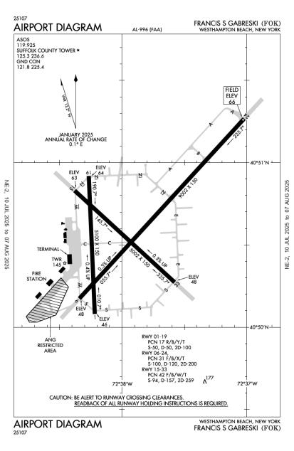
(KFOK) Francis S Gabreski Airport
No ratings | 2 reviews
Overview
Attendance:
Attended
Year-round, 7 Days a Week,0700-2300
FAA
Elevation:
66 ft (Surveyed)
Tower:
Atct Oprd By Suffolk Atc Corp.
FAA
Tower Hrs: 0700-2300
FAA
Airspace:
CLASS D SVC 0700-2300; OTHER TIMES CLASS G
FAA
Fees:
Timezone:
EDT (UTC-04:00)
Sunrise-Sunset:
5:52 am - 7:45 pm
Evening-Morning Civil Twilight:
8:15 pm
(Today)
(Today)
-
5:21 am
(Tomorrow)
(Tomorrow)
Minimum Fuel Prices:
$8.26
100LL (full)
$8.08
Jet-A (full)
$8.23
Jet-A-Premix/Prist (full)
Runway
Satellite
Sectional
FBOs
Submit New FBO
Modern Aviation
1 rating | 1 review
Services Offered:
Car Rental
$8.26 | 100LL | full
$8.08 | Jet-A | full
$8.23 | Jet-A-Premix/Prist | full
Location:
On field: NW
Phone:
(631) 288-9866
Freq. Monitored:
ASRI: 130.2
Fees:
Landing, Overnight, Ramp, Other
Flight Training
Submit New Flight School
Other businesses
Submit New Business
AOPA Travel Discounts 
FlightBridge is the ultimate all-in-one travel booking platform built for the general aviation community. AOPA Members receive free access to FlightBridge with AOPA discounted rates automatically applied. Members save an average of 30% on hotel bookings! Learn more about FlightBridge HERE.
Local Food/Lodging/Activities
Local Attractions
Local Activities
Restaurants
Hotels and Lodging
Travel Discounts
(631) 288-1654
(631) 849-6220
Café Dolo (Wed-Sun 8am-3pm)
335 Sheldon Way, Westhampton Beach, NY 11978
(631) 998-3573
900 Route 33 East, Freehold, NJ 07728
(732) 577-0023
FOK
Rogers Beach
Holey Moses Cheesecake
Café Dolo (Wed-Sun 8am-3pm)
Concorde Worldwide Transportation
Flying Clubs
Submit New Flying Club
Runway 06/24
Dimensions:
9,002 × 150 ft
(2,744 × 46 m)
(2,744 × 46 m)
Weight Bearing Cap:
Single wheel: 100,000 lbs
Double wheel: 120,000 lbs
Double tandem: 200,000 lbs
Double wheel: 120,000 lbs
Double tandem: 200,000 lbs
Surface:
asphalt, concrete, no surface treatment, in good condition
Runway Edge Lights:
High
Comments:
6000 Ft Asph Overlay in Cntr of Rwy.
FAA
Rwy 06/24 1000 Ft Safety Area Each End.
FAA
| Designator: | 06 | 24 |
| Elevation: | 47.5 ft | 66.1 ft |
| Heading: | 056° magnetic 043° true | 236° magnetic 223° true |
| Gradient: | 0.21% up | 0.21% down |
| Traffic Pattern: | Left Pattern | Right Pattern |
| Markings: | precision, in Good condition | precision, in Good condition |
| Approach Lighting: |
|
|
| Displaced Threshold: | n/a | n/a |
| ILS/LOC: | n/a | ILS/DME |
| Obstructions: | Trees, 410 ft Right ft of center, 30 ft high, 200 ft from end | Trees, 483 ft Left ft of center, 74 ft high, 1,237 ft from end, 14:1 clearance slope |
| Comments: | +30 Ft Trees, 135-285 Ft Fm Rwy End, 357-530 Ft Right; +50 Ft Structure, 1500 Ft Fm Rwy, 78 Ft Right. FAA Vgsi and Rnav Glidepath not Coincident. FAA | +85 Ft to 91 Ft Trees, 2160 Ft to 2350 Ft Fm Rwy, Perpendicular to Extdd Rwy Cntrln. FAA Vgsi and Ils Glidepath not Coincident. FAA |
Runway 01/19
Dimensions:
5,100 × 150 ft
(1,554 × 46 m)
(1,554 × 46 m)
Weight Bearing Cap:
Single wheel: 50,000 lbs
Double wheel: 50,000 lbs
Double tandem: 100,000 lbs
Double wheel: 50,000 lbs
Double tandem: 100,000 lbs
Surface:
asphalt, concrete, no surface treatment, in good condition
Runway Edge Lights:
n/a
Comments:
South End Rwy 900 Ft & North End Rwy 1000 Ft are Safety Areas.
FAA
| Designator: | 01 | 19 |
| Elevation: | 46.3 ft | 64.2 ft |
| Heading: | 370° magnetic 357° true | 190° magnetic 177° true |
| Gradient: | 0.35% up | 0.35% down |
| Traffic Pattern: | Not provided. Assume LEFT traffic pattern | Not provided. Assume LEFT traffic pattern |
| Markings: | basic, in Good condition | basic, in Good condition |
| Approach Lighting: | n/a | n/a |
| Displaced Threshold: | n/a | n/a |
| ILS/LOC: | n/a | n/a |
| Obstructions: | Trees, 219 ft Left ft of center, 55 ft high, 1,342 ft from end, 20:1 clearance slope | Trees, 337 ft Right ft of center, 47 ft high, 1,080 ft from end, 18:1 clearance slope |
| Comments: | +40 Ft to 55 Ft Trees, 1280 Ft to 1360 Ft Fm Rwy, Perpendicular to Extdd Rwy Cntrln. FAA | +33 Ft to 47 Ft Trees, 1000 Ft to 1080 Ft Fm Rwy, Perpendicular to Extdd Rwy Cntrln. FAA |
Runway 15/33
Dimensions:
5,002 × 150 ft
(1,525 × 46 m)
(1,525 × 46 m)
Weight Bearing Cap:
Single wheel: 94,000 lbs
Double wheel: 157,000 lbs
Double tandem: 259,000 lbs
Double wheel: 157,000 lbs
Double tandem: 259,000 lbs
Surface:
asphalt, no surface treatment, in good condition
Runway Edge Lights:
Medium
Comments:
Rwy 15/33 1000 Ft Safety Area Each End.
FAA
| Designator: | 15 | 33 |
| Elevation: | 63 ft | 48.1 ft |
| Heading: | 145° magnetic 132° true | 326° magnetic 313° true |
| Gradient: | 0.3% down | 0.3% up |
| Traffic Pattern: | Left Pattern | Right Pattern |
| Markings: | non-precision, in Good condition | non-precision, in Good condition |
| Approach Lighting: |
|
|
| Displaced Threshold: | n/a | n/a |
| ILS/LOC: | n/a | n/a |
| Obstructions: | Trees, 185 ft Left ft of center, 68 ft high, 1,072 ft from end, 12:1 clearance slope | Trees, 87 ft Left ft of center, 30 ft high, 1,035 ft from end, 27:1 clearance slope |
| Comments: | +35 Ft to 52 Ft Trees, 1112 Ft to 1141 Ft Fm Rwy, Perpendicular to Extdd Rwy Cntrln. FAA 15/33 Mil Max Effort Ldg Strip Mkgs (3500 X 60) Incld with Npi Rwy Mkgs. FAA | +30 Ft to 33 Ft Trees, 1035 Ft to 1103 Ft Fm Rwy, Perpendicular to Extdd Rwy Cntrln. FAA |
TFRs
Location: FOK
Please verify all content below using the FAA TFR Search Site or with a flight briefer.
TFR count: 0
NOTAMs
Location: FOK
Please verify all content below using the FAA NOTAM Search Site or with a flight briefer.
NOTAM count: 10 (Partial list shown. Expand to see full list HERE.)
| Number: | Start Date: (UTC) | End Date: (UTC) | Condition: |
|---|---|---|---|
| M0046/25 | 05/02/2025 1500 | 05/02/2025 1800 | PARACHUTE JUMPING EXERCISES WITHIN AREA DEFINED AS 2NM RADIUS OF KFOK
|
| 5/8234 | 03/26/2025 1753 | IAP FRANCIS S GABRESKI, WESTHAMPTON BEACH, NY.
ILS OR LOC RWY 24, AMDT 11A...
RNAV (GPS) RWY 24, AMDT 2C...
… | |
| 5/0655 | 04/01/2025 2132 | IAP FRANCIS S GABRESKI, WESTHAMPTON BEACH, NY.
ILS OR LOC RWY 24, AMDT 11A...
RADAR REQUIRED FOR PROCEDURE E… | |
| M0043/25 | 04/29/2025 2300 | 04/30/2025 0200 | PARACHUTE JUMPING EXERCISES WITHIN AREA DEFINED AS 2NM RADIUS OF KFOK
|
| 5/8233 | 03/26/2025 1752 | IAP FRANCIS S GABRESKI, WESTHAMPTON BEACH, NY.
TACAN RWY 24, ORIG-C...
TACAN RWY 6, ORIG-C...
CIRCLING RWY 1… | |
| M0047/25 | 05/03/2025 1530 | 05/03/2025 1830 | PARACHUTE JUMPING EXERCISES WITHIN AREA DEFINED AS 2NM RADIUS OF KFOK
|
| 04/043 | 04/28/2025 1145 | 05/01/2025 1900 | TWY W BTN APCH END RWY 15 AND TWY C CLSD |
| 5/6723 | 04/15/2025 1938 | IAP FRANCIS S GABRESKI, WESTHAMPTON BEACH, NY.
ILS OR LOC RWY 24, AMDT 11A...
TERMINAL ROUTE FROM HTO VOR/DM… | |
Additional Remarks
Ang: Advsy for Tran Aircrews - Wing Tip Clnc Waiver in Effect on Guard C-130 Ramp.
Source:
FAA
Federal Aviation Administration
Bearing Stength Rwy 06-24: S54 T110 St175 Sbtt600 Tt300 Tdt900 Ddt850 Trt720.
Source:
FAA
Federal Aviation Administration
Bearing Stength Rwy 15-33: S54 T120 St175 Sbtt430 Tt250 Tdt740 Ddt540 Trt580.
Source:
FAA
Federal Aviation Administration
Bearing Strength Rwy 01-19: S50 T50 St175 Tt100.
Source:
FAA
Federal Aviation Administration
Caution: Birds and Deer Haz. Pje Vcnty of Arpt.
Source:
FAA
Federal Aviation Administration
Class D Airspace Eff 1200-0400Z++; Ot Class G.
Source:
FAA
Federal Aviation Administration
Cstms/Ag/Img: US Cstms Clnc Svc Avbl with Pn (Frg) 631-753-2691 (Mil Flts Will Coord Thru Base Operations 631-723-7362/7364). Min 24 Hr Pn on Rglr Bus Day Precdng Svc Rqr Date, Max Pax 15. US Cstms Hrs between 0800 and 2200 Local.
Source:
FAA
Federal Aviation Administration
Fluid - Sp De-Ice Lox.
Source:
FAA
Federal Aviation Administration
For Cd When Air Traffic Control Tower Clsd CTC New York Approach at 516-683-2449.
Source:
FAA
Federal Aviation Administration
Fuel: Avbl Dur Ang Opr Hr. J8(Mil) (Nc-100LL, A).
Source:
FAA
Federal Aviation Administration
Fuel: A++ (Mil) Avbl.
Source:
FAA
Federal Aviation Administration
Jasu: Avbl Dur Ang Opr Hr. (A/M32A-86) 2(Ma-1A).
Source:
FAA
Federal Aviation Administration
Military: Ang: Prior Permission Required Offl Bus. for Use of Ang Ramp. Offl Bus Only Prior Permission Required All Acft, 48 Hr Pn, CTC Airfield Operations Dsn 456-7362, C631-723-7362 Drg Duty Hr. Tue-Fri Prior Permission Required Drg Off-Duty Hr. 106 Og/Cc Apvl Required Nml Duty Hr. Nml Duty Hr 1200-2130++ Mon-Fri. Clsd Sat, Sun, Hol and Ev Other Mon. Ltd Ramp Space. Tran Acft May be Diverted to Civ FBO Drg Non-Duty Hr. Non-Standard Markings on Hh-60 Apron; White Painted Lines Denoting A Roadway on the Apron by the Pods Indicating Where A Vehicle Must Drive in Order to Maintain All Necessary Wingtip Clearances.
Source:
FAA
Federal Aviation Administration
Oil - O-148-156(Mil) Soap.
Source:
FAA
Federal Aviation Administration
Rcmdd Rsvn with FBO Prior to Arr.
Source:
FAA
Federal Aviation Administration
Rstd - No 180 Deg Turns Pmtd on Asph Section of Rwy 06/24.
Source:
FAA
Federal Aviation Administration
Voluntary Noise Abatement Procs in Efct; See Airport Website.
Source:
FAA
Federal Aviation Administration
When Safety and Operations Allow, Rwy 24 Pref for Noise Abatement.
Source:
FAA
Federal Aviation Administration
Noise Abatement
Instrument Procedures
Operations & More Information
Lat/Long:
- 40.84362, -72.63181
- 40° 50′ 37.0″ N, 72° 37′ 54.5″ W
- 40° 50.617′ N, 72° 37.909′ W
ARTCC:
New York (ZNY)
App/Depart Control Facility:
N90
Chart:
NACO: New York Sectional
FSS:
New York (ISP)
1-800-WX-BRIEF
1-800-WX-BRIEF
Wind Indicator:
Yes
Mag Var:
13W (1980)
NOTAM Facility:
Seg Circle:
No
Beacon:
Present
Lighting:
Pilot Activated Lighting:
- medium intensity: 5 clicks in 7 secs
AM
When Air Traffic Control Tower Clsd Actvt MALSR Rwy 24; REIL Rwy 06, 15, & 33; PAPI Rwy 06, 15 & 24; VASI Rwy 33; HIRL Rwy 06/24; MIRL Rwy 15/33 - CTAF.
FAA
Pattern Altitude:
No data provided. Assume 1000 AGL.
Special Operations:
Communications Card
| Type: | Frequency / Phone: | Sector / Comments: | Call Sign: |
|---|---|---|---|
| Approach/Departure | 125.975 | New York | |
| ASOS | 119.925T (631) 288-0588 | Suffolk | |
| CTAF | 125.3 | Suffolk | |
| Emergency | 121.5 | Suffolk | |
| Ground Control | 121.8 | Suffolk | |
| NELIE STAR | 120.05 | New York | |
| Tower | 125.3 | Suffolk |
Navaids
Services
Fuel:
100LL Low-Lead, Jet A
AM
Engine Repair:
Major
AM
Airframe Repair:
Major
AM
Bottled Oxygen:
High/Low
AM
Bulk Oxygen:
None
Customs:
International Landing Rights
AM
Transportation:
Limousine, Public Transportation
AM
Activities:
Intensive Flight Training, On field restaurant/café
AM
Camping On Field:
None Reported
Aircraft & Activity
Webcams
METARs
TAFs
Contact Addresses
Airport Manager
Joshua Smith
Westhampton, NY 11978
(631) 852-8095 (Office)
Owner
County of Suffolk
Riverhead, NY 11901
(631) 852-8095 (Office)
Airport Reviews
Overall:
No ratings | 2 reviews
Runways and Taxiways:No ratings
Markings and Signage:No ratings
Ground Transportation:No ratings
Sort By:
- 7/10/17RICHARD K.Re US Customs- I was checking US Custom fees around some Long Island airports for a return from Canada and was shocked to find that Sheltair at FOK wants $450 for the privilege of sitting for 15 minutes on their ramp while a Customs official checks y…
- 3/7/15SEBASTIAN C.You fellow pilots must come down and try The Apron Cafe The food is good and if you want a pies you can go right next door. To Holly mosses pies. Call for hours 631-288-2919 Tess is the owner. It's time to all to get back in the air. And have fun.