FAA Information Effective: May 15, 2025
All information is provided from the FAA unless otherwise noted.
(KCOE) Coeur D'Alene/Pappy Boyington Field
2 ratings | 5 reviews
Overview
Attendance:
Attended
Year-round, 7 Days a Week,0700-1700
FAA
Elevation:
2,320 ft (Surveyed)
Tower:
No
Airspace:
E
Fees:
Timezone:
PDT (UTC-07:00)
Sunrise-Sunset:
5:06 am - 8:23 pm
Evening-Morning Civil Twilight:
9:00 pm
(Today)
(Today)
-
4:28 am
(Tomorrow)
(Tomorrow)
Minimum Fuel Prices:
$6.72
100LL (full)
$5.42
100LL (self)
$7.60
Jet-A (full)
$7.70
Jet-A-Premix/Prist (full)
Runway
Satellite
Sectional
FBOs
Submit New FBO
StanCraft Jet Center
1 rating | 1 review
Services Offered:
Car Rental
$6.72 | 100LL | full
$5.42 | 100LL | self
$7.60 | Jet-A | full
$7.70 | Jet-A-Premix/Prist | full
Location:
On field: N
Phone:
(208) 772-6404
Freq. Monitored:
UNICOM: 122.8
Fees:
Handling, Other
Flight Training
Submit New Flight School
Other businesses
Submit New Business
AOPA Travel Discounts 
FlightBridge is the ultimate all-in-one travel booking platform built for the general aviation community. AOPA Members receive free access to FlightBridge with AOPA discounted rates automatically applied. Members save an average of 30% on hotel bookings! Learn more about FlightBridge HERE.
Local Food/Lodging/Activities
Local Attractions
Local Activities
Restaurants
Hotels and Lodging
Travel Discounts
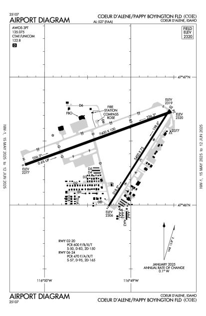
Runway 06/24
Dimensions:
7,400 × 100 ft
(2,256 × 30 m)
(2,256 × 30 m)
Weight Bearing Cap:
Single wheel: 57,000 lbs
Double wheel: 95,000 lbs
Double tandem: 165,000 lbs
Double wheel: 95,000 lbs
Double tandem: 165,000 lbs
Surface:
asphalt, grooved, in good condition
Runway Edge Lights:
High
Comments:
Pcr Value: 470/F/A/X/T
FAA
| Designator: | 06 | 24 |
| Elevation: | 2,277.4 ft | 2,320.3 ft |
| Heading: | 051° magnetic 070° true | 231° magnetic 250° true |
| Gradient: | 0.58% up | 0.58% down |
| Traffic Pattern: | Left Pattern | Left Pattern |
| Markings: | precision, in Good condition | precision, in Good condition |
| Approach Lighting: |
|
|
| Displaced Threshold: | n/a | n/a |
| ILS/LOC: | ILS | n/a |
| Obstructions: | n/a | n/a |
| Comments: | Ry 06 Nstd Malsr; Thld Bar Extends 5 Ft Byd Ry Edge Lgts Each Side. FAA | n/a |
Runway 02/20
Dimensions:
5,400 × 75 ft
(1,646 × 23 m)
(1,646 × 23 m)
Weight Bearing Cap:
Single wheel: 50,000 lbs
Double wheel: 83,000 lbs
Double tandem: 150,000 lbs
Double wheel: 83,000 lbs
Double tandem: 150,000 lbs
Surface:
asphalt, grooved, in good condition
Runway Edge Lights:
Medium
Comments:
Pcr Value: 600/F/B/X/T
FAA
| Designator: | 02 | 20 |
| Elevation: | 2,305.6 ft | 2,319 ft |
| Heading: | 013° magnetic 032° true | 193° magnetic 212° true |
| Gradient: | 0.25% up | 0.25% down |
| Traffic Pattern: | Right Pattern | Left Pattern |
| Markings: | non-precision, in Good condition | non-precision, in Good condition |
| Approach Lighting: |
|
|
| Displaced Threshold: | n/a | n/a |
| ILS/LOC: | n/a | n/a |
| Obstructions: | n/a | n/a |
| Comments: | n/a | Calm wind RWY AM |
TFRs
Location: COE
Please verify all content below using the FAA TFR Search Site or with a flight briefer.
TFR count: 0
NOTAMs
Location: COE
Please verify all content below using the FAA NOTAM Search Site or with a flight briefer.
NOTAM count: 15 (Partial list shown. Expand to see full list HERE.)
| Number: | Start Date: (UTC) | End Date: (UTC) | Condition: |
|---|---|---|---|
| 03/045 | 03/12/2025 1600 | 11/02/2025 0500 | AIRSPACE NUMEROUS UAS WI AN AREA DEFINED AS .5NM RADIUS OF 474523N1171111W (7.3NM ESE 70S) SFC-400FT AGL DLY… |
| 05/047 | 05/19/2025 1500 | 06/25/2025 2359 | SVC AUTOMATED WX BCST SYSTEM U/S |
| 05/050 | 05/15/2025 2344 | 05/19/2025 2359 | APRON WEST RAMP CLSD EMERG VEHICLE TRG |
| 5/7081 | 03/26/2025 1300 | 06/15/2025 1300 | IAP COEUR D'ALENE/PAPPY BOYINGTON FLD,
COEUR D'ALENE, ID.
RNAV (GPS) RWY 2, ORIG-A...
RNAV (GPS) RWY 6, ORIG… |
| 05/039 | 05/15/2025 1600 | 09/30/2025 0200 | SVC TEMPO TWR LOCAL CTL 120.125, GND CTL 128.075, FOR CLR DELIVERY CTC SPOKANE APP 509-742-2522 DLY 1600-020… |
| 05/049 | 05/19/2025 1500 | 06/25/2025 2359 | RWY 06 PAPI U/S |
| 03/210 | 03/27/2025 1138 | 12/31/2025 0208 | AIRSPACE SEE COE 03/209 NUMEROUS LOW FLYING FLOAT PLANE ACFT 2503271138-2512310208 DLY SR-SS |
| 03/044 | 03/12/2025 1600 | 11/02/2025 0500 | AIRSPACE NUMEROUS UAS WI AN AREA DEFINED AS .5NM RADIUS OF 475357N1164225W (8NM NE COE) SFC-400FT AGL DLY 16… |
Additional Remarks
For Cd If Una CTC on 132.1 CTC Spokane Approach at 509-742-2522.
Source:
FAA
Federal Aviation Administration
Migratory Birds on & In vicinity of Airport Oct-Nov.
Source:
FAA
Federal Aviation Administration
Pje in Vcnty.
Source:
FAA
Federal Aviation Administration
Rwy: Conds not Mntd 5 Pm to 7 Am Dly.
Source:
FAA
Federal Aviation Administration
48 Hr Prior Permission Required for Unsked Operations with More Than 30 Psgr Seats Call Airport Manager 208-446-1860.
Source:
FAA
Federal Aviation Administration
Noise Abatement
Instrument Procedures
Data Cycle:
Operations & More Information
Lat/Long:
- 47.77431, -116.81958
- 47° 46′ 27.5″ N, 116° 49′ 10.5″ W
- 47° 46.458′ N, 116° 49.175′ W
ARTCC:
Seattle (ZSE)
App/Depart Control Facility:
GEG
Chart:
NACO: Great Falls Sectional
FSS:
Boise (BOI)
1-800-WX-BRIEF
1-800-WX-BRIEF
Wind Indicator:
Lighted
Mag Var:
19E (1990)
NOTAM Facility:
Seg Circle:
Yes
Beacon:
Present
Lighting:
Pilot Activated Lighting:
- low intensity: 3 clicks in 4 secs
- medium intensity: 5 clicks in 6 secs
- high intensity: 7 clicks in 8 secs
AM
Actvt MIRL Ry 02/20, HIRL Ry 06/24, REIL Rys 02 & 24, & MALSR Ry 06 - CTAF. PAPI Rys 02, 20, 06, & 24 Oper Continuously.
FAA
Pattern Altitude:
No data provided. Assume 1000 AGL.
Special Operations:
Communications Card
| Type: | Frequency / Phone: | Sector / Comments: | Call Sign: |
|---|---|---|---|
| Approach/Departure | 132.1 | Spokane | |
| AWOS-3PT | 135.075T (208) 772-8215 | ||
| CTAF | 122.8 | ||
| UNICOM | 122.8 |
Navaids
Services
Fuel:
100 Octane, Jet A
AM
Engine Repair:
Major
AM
Airframe Repair:
Major
AM
Bottled Oxygen:
High/Low
AM
Bulk Oxygen:
High/Low
AM
Customs:
None
Transportation:
Courtesy Transportation
AM
Activities:
None Reported
Camping On Field:
None Reported
Aircraft & Activity
Webcams
| Name: | Operated by: | Site: | Facing: |
|---|---|---|---|
| Taxiway D3 Cam | Airport | Airport Hangar | S |
| Taxiway D Cam | Airport | Airport Building | SE |
METARs
TAFs
Contact Addresses
Airport Manager
Gaston Patterson
Hayden, ID 83835
(208) 446-1860 (Office)
Owner
Kootenai County
Coeur D Alene, ID 83816
(208) 446-1600 (Office)
Airport Reviews
Overall:
2 ratings | 5 reviews
Runways and Taxiways:
Markings and Signage:
Ground Transportation:No ratings
Sort By:
- 9/27/21airport is in great conditionJennifer S.Busy airport with instrument approaches into 06. Winds seem to favor 20, so you have jets coming in at an angle towards you if you are landing on 20. Airport is well-marked. Resort aviation currently has cheapest fuel and it is full-service. You can …
- 5/23/18J K.I found Southfield personnel extremely friendly and helpful - could not ask for more - fuel and told where I could park for most of the day without charge. VERY FREINDLY and NICE PEOPLE. The rest of the airport including the personnel in the Airpor…
- 8/10/17MATTHEW C.If you plan on flying in and are basing your plans on the posted fuel prices, you may be in for a shock. Call ahead and find out what they really are charging.
- 7/22/13CARL H.I started flying in to COE last year and have found Southfield Fuels, with Larry & Liz, to be some of the best service I have EVER encountered at an airport. This is the type of operator that would give you the shirt right off their backs! They have …
- 7/18/13MICHAEL K.SInce there is no longer a Runway 19, it is no longer the designated calm wind runway. Please correct to Runway 20.