FAA Information Effective: Apr 17, 2025
All information is provided from the FAA unless otherwise noted.
(KCOD) Yellowstone Regional Airport
No ratings | 4 reviews
Overview
Attendance:
Attended
Year-round, 7 Days a Week,0500-2200
FAA
Runways:
04/22
Runway length: 8,268 ft (2,520 m)
Elevation:
5,102 ft (Surveyed)
Tower:
No
Airspace:
CLASS E SVC CONTINUOUS
FAA
Fees:
None
Timezone:
MDT (UTC-06:00)
Sunrise-Sunset:
5:56 am - 8:31 pm
Evening-Morning Civil Twilight:
9:04 pm
(Today)
(Today)
-
5:22 am
(Tomorrow)
(Tomorrow)
Minimum Fuel Prices:
$7.40
100LL (full)
$6.30
100LL (self)
$7.24
Jet-A (full)
$7.33
Jet-A-Premix/Prist (full)
Runway
Satellite
Sectional
FBOs
Submit New FBO
Flight Training
Submit New Flight School
Other businesses
Submit New Business
AOPA Travel Discounts 
FlightBridge is the ultimate all-in-one travel booking platform built for the general aviation community. AOPA Members receive free access to FlightBridge with AOPA discounted rates automatically applied. Members save an average of 30% on hotel bookings! Learn more about FlightBridge HERE.
Local Food/Lodging/Activities
Local Attractions
Local Activities
Restaurants
Hotels and Lodging
Travel Discounts
(307) 587-2369
(307) 587-6500
(307) 527-6424
(307) 587-5900
(307) 527-9900
COD
Cody KOA
Buffalo Bill Historical Center
Olive Glenn Golf
Burger King
Taco John's
McDonald's
Stewart's Mercantile
Flying Clubs
Submit New Flying Club
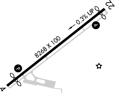
Runway 04/22
Dimensions:
8,268 × 100 ft
(2,520 × 30 m)
(2,520 × 30 m)
Weight Bearing Cap:
Single wheel: 95,000 lbs
Double wheel: 124,000 lbs
Double tandem: 193,000 lbs
Double wheel: 124,000 lbs
Double tandem: 193,000 lbs
Surface:
asphalt, grooved, in good condition
Runway Edge Lights:
High
Comments:
Pcr Value: 300/F/D/X/T
FAA
| Designator: | 04 | 22 |
| Elevation: | 5,102.3 ft | 5,075.1 ft |
| Heading: | 041° magnetic 052° true | 221° magnetic 232° true |
| Gradient: | 0.33% down | 0.33% up |
| Traffic Pattern: | Left Pattern | Left Pattern |
| Markings: | precision, in Good condition | precision, in Good condition |
| Approach Lighting: |
|
|
| Displaced Threshold: | 690 ft | 400 ft |
| ILS/LOC: | n/a | n/a |
| Obstructions: | Pole, 240 ft Left ft of center, 15 ft high, 731 ft from end, 35:1 clearance slope | Terrain, 404 ft Left ft of center, 55 ft high, 2,087 ft from end, 34:1 clearance slope |
| Comments: | +345' Poles on Hill on Cntrln Extdd. FAA Papi Unusbl Byd 4.0 Nm Due to Rpdly Rsg Trrn N of Final to Rwy 04 FAA | +84' Poles on Hill on Cntrln Extdd. FAA |
TFRs
Location: COD
Please verify all content below using the FAA TFR Search Site or with a flight briefer.
TFR count: 0
NOTAMs
Location: COD
Please verify all content below using the FAA NOTAM Search Site or with a flight briefer.
NOTAM count: 5
| Number: | Start Date: (UTC) | End Date: (UTC) | Condition: |
|---|---|---|---|
| 05/021 | 05/08/2025 1133 | 05/14/2025 0100 | AD AP WINDCONE PRI LGT U/S |
| 07/021 | 07/31/2024 1942 | 07/31/2025 2359 | RWY 04 RWY END ID LGT U/S |
| 05/022 | 05/08/2025 1524 | COM REMOTE COM OUTLET 122.3 U/S | |
| 05/001 | 05/01/2025 1002 | 06/15/2025 1001 | OBST TOWER LGT (ASR 1009208) 443318.00N1090212.00W (2.2NM NNW COD) 5241.5FT (201.8FT AGL) U/S |
| 04/063 | 04/28/2025 1806 | 10/31/2025 2359 | OBST TOWER LGT (ASR 1009088) 442945.80N1090911.50W (5.7NM WSW COD) 7700.1FT (120.1FT AGL) U/S |
Additional Remarks
Airfield Sfc Conds are not Mntnd Btwn Hrs of 2300 - 0500.
Source:
FAA
Federal Aviation Administration
Call Out After Hrs Svc Fm Choice Aviation is 307-587-9262.
Source:
FAA
Federal Aviation Administration
Cold Temperature Airport. Altitude Correction Required At or Below -10C.
Source:
FAA
Federal Aviation Administration
For Cd If Una to CTC on FSS Freq, CTC Salt Lake ARTCC at 801-320-2568.
Source:
FAA
Federal Aviation Administration
Low Level Waterfowl on Lake 1/4 Mile 'se' of Ry 4 Thld.
Source:
FAA
Federal Aviation Administration
Clsd to Unsked Acr Operations with More Than 30 Psgr Seats Excp Prior Permission Required Call Airport Operations 307-899-5096.
Source:
FAA
Federal Aviation Administration
Security Directive SD-8G
Source:
AM
Airport Manager
Noise Abatement
Instrument Procedures
Data Cycle:
Operations & More Information
Lat/Long:
- 44.52019, -109.02381
- 44° 31′ 12.7″ N, 109° 1′ 25.7″ W
- 44° 31.212′ N, 109° 1.428′ W
ARTCC:
Salt Lake City (ZLC)
App/Depart Control Facility:
Unknown
Chart:
NACO: Great Falls Sectional
FSS:
Casper (CPR)
1-800-WX-BRIEF
1-800-WX-BRIEF
Wind Indicator:
Lighted
Mag Var:
11E (2020)
NOTAM Facility:
Seg Circle:
Yes
Beacon:
Present
Lighting:
Pilot Activated Lighting:
- low intensity: 3 clicks in 5 secs
- medium intensity: 5 clicks in 5 secs
- high intensity: 7 clicks in 5 secs
AM
Actvt HIRL and REIL Ry 04/22 - CTAF
FAA
Pattern Altitude:
Light Aircraft 5900 MSL
Heavy Aircraft 6100 MSL
AM
Special Operations:
Communications Card
| Type: | Frequency / Phone: | Sector / Comments: | Call Sign: |
|---|---|---|---|
| AWOS-3PT | 135.075T (307) 527-5197 | ||
| CTAF | 122.8 | ||
| UNICOM | 122.8 |
Navaids
Services
Fuel:
100 Octane, 100LL Low-Lead, Jet A
AM
Engine Repair:
Major
AM
Airframe Repair:
Major
AM
Bottled Oxygen:
None
Bulk Oxygen:
High
AM
Customs:
None
Transportation:
Courtesy Transportation, Limousine
AM
Activities:
None Reported
Camping On Field:
None Reported
Aircraft & Activity
Webcams
METARs
TAFs
Contact Addresses
Airport Manager
Aaron Buck
Cody, WY 82414
(307) 587-5096 (Office)
Owner
City of Cody
Cody, WY 82414
(307) 527-7511 (Office)
Airport Reviews
Overall:
No ratings | 4 reviews
Runways and Taxiways:No ratings
Markings and Signage:No ratings
Ground Transportation:No ratings
Sort By:
- 5/30/18Matthew C.We flew into COD on the 20th of May 2018 and had a GREAT experience. I called several days in advance so I would have an idea of what to expect when I arrived. I called Choice Aviation and talked to Candice and she was very beyond helpful. I menti…
- 10/20/16VICENTE C.Landed there last Thursday for a 3 day visit to Yellowstone Park. The folks at Choice Aviation could not have been nicer. They had my rental car ready for me, and fueled my plane immediately as I had requested. I have entered the park from the west a…
- 6/17/14VINCENT B.Just flew in over the weekend with my son in our old 210, was greeted by Eric and Shelly and was overcome by their hospitality, helpfulness and friendliness. I cannot say enough good things about them!
- 9/8/13THOMAS K.Used Spirit Air. Great and friendly service. Buck, the owner, is a fountain of local knowledge. Bought gas (lowest price on the field) and parked for no charge for three nights. The FBO is not fancy, but certainly adequate.