FAA Information Effective: May 15, 2025
All information is provided from the FAA unless otherwise noted.
(KCIR) Cairo Regional Airport
No ratings | 3 reviews
Cairo, IL
(618) 734-0600
Overview
Attendance:
Attended
Year-round,Mon-Sat/0900-1700
FAA
Year-round,Sun/Irreg
FAA
Elevation:
322 ft (Surveyed)
Tower:
No
Airspace:
Unknown
Fees:
Landing, Ramp, Tie Down, Other
Click FBO link(s) below for details:
Click FBO link(s) below for details:
FBO Fee Details:
Cairo Regional AirportTimezone:
CDT (UTC-05:00)
Sunrise-Sunset:
5:47 am - 8:01 pm
Evening-Morning Civil Twilight:
8:31 pm
(Today)
(Today)
-
5:17 am
(Tomorrow)
(Tomorrow)
Minimum Fuel Prices:
$4.95
100LL (self)
Runway
Satellite
Sectional
FBOs
Submit New FBO
Cairo Regional Airport
No ratings | Be the first to review this business
Services Offered:
Car Rental
$4.95 | 100LL | self
Location:
On field: SW
Phone:
(618) 734-0600
Freq. Monitored:
Fees:
Landing, Ramp, Tie Down, Other
Flight Training
Submit New Flight School
Other businesses
Submit New Business
AOPA Travel Discounts 
FlightBridge is the ultimate all-in-one travel booking platform built for the general aviation community. AOPA Members receive free access to FlightBridge with AOPA discounted rates automatically applied. Members save an average of 30% on hotel bookings! Learn more about FlightBridge HERE.
Local Food/Lodging/Activities
Local Attractions
Local Activities
Restaurants
Hotels and Lodging
Travel Discounts
Flying Clubs
Submit New Flying Club
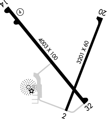
Runway 14/32
Dimensions:
4,001 × 100 ft
(1,220 × 30 m)
(1,220 × 30 m)
Weight Bearing Cap:
Single wheel: 30,000 lbs
Double wheel: 35,000 lbs
Double wheel: 35,000 lbs
Surface:
asphalt, no surface treatment, in fair condition
Runway Edge Lights:
Medium
Comments:
n/a
| Designator: | 14 | 32 |
| Elevation: | 313.6 ft | 319.4 ft |
| Heading: | 141° true | 321° true |
| Gradient: | 0.14% up | 0.14% down |
| Traffic Pattern: | Left Pattern | Left Pattern |
| Markings: | non-precision, in Fair condition | non-precision, in Fair condition |
| Approach Lighting: |
| n/a |
| Displaced Threshold: | n/a | n/a |
| ILS/LOC: | n/a | n/a |
| Obstructions: | n/a | n/a |
| Comments: | n/a | n/a |
Runway 02/20
Dimensions:
3,200 × 60 ft
(975 × 18 m)
(975 × 18 m)
Weight Bearing Cap:
Single wheel: 6,000 lbs
Surface:
asphalt, no surface treatment, in fair condition
Runway Edge Lights:
Medium
Comments:
n/a
| Designator: | 02 | 20 |
| Elevation: | 318.4 ft | 318.9 ft |
| Heading: | 021° true | 201° true |
| Gradient: | 0.02% up | 0.02% down |
| Traffic Pattern: | Left Pattern | Left Pattern |
| Markings: | basic, in Fair condition | basic, in Fair condition |
| Approach Lighting: | n/a | n/a |
| Displaced Threshold: | n/a | n/a |
| ILS/LOC: | n/a | n/a |
| Obstructions: | n/a | n/a |
| Comments: | n/a | n/a |
TFRs
Location: CIR
Please verify all content below using the FAA TFR Search Site or with a flight briefer.
TFR count: 0
NOTAMs
Location: CIR
Please verify all content below using the FAA NOTAM Search Site or with a flight briefer.
NOTAM count: 5
| Number: | Start Date: (UTC) | End Date: (UTC) | Condition: |
|---|---|---|---|
| 05/007 | 05/17/2025 1303 | 09/14/2025 1303 | OBST TOWER LGT (ASR 1254250) 370906.30N0891005.40W (5.8NM NNE CIR) 727.0FT (288.1FT AGL) U/S |
| 05/002 | 05/03/2025 0317 | 06/05/2025 2300 | OBST TOWER LGT (ASR 1009639) 371127.40N0890949.90W (8.1NM NNE CIR) 767.7FT (309.7FT AGL) U/S |
| 05/004 | 05/06/2025 1332 | NAV NDB UNUSABLE | |
| 04/007 | 04/13/2025 2108 | 05/28/2025 2108 | OBST TOWER LGT (ASR 1310885) 371116.02N0890508.93W (9.8NM NE CIR) 621FT (275FT AGL) U/S |
| 05/005 | 05/09/2025 0207 | 06/23/2025 0206 | OBST TOWER LGT (ASN 2020-AGL-9649-OE) 370460N0891019W (2.6NM ENE CIR) 554FT (239FT AGL) U/S |
Additional Remarks
For Clearance Delivery Contact Memphis ARTCC at 901-368-8453/8449.
Source:
FAA
Federal Aviation Administration
Noise Abatement
Instrument Procedures
Data Cycle:
Operations & More Information
Lat/Long:
- 37.06414, -89.21953
- 37° 3′ 50.9″ N, 89° 13′ 10.3″ W
- 37° 3.848′ N, 89° 13.172′ W
ARTCC:
Memphis (ZME)
App/Depart Control Facility:
Unknown
Chart:
NACO: St Louis Sectional
FSS:
Saint Louis (STL)
1-800-WX-BRIEF
1-800-WX-BRIEF
Wind Indicator:
Lighted
Mag Var:
00 (1995)
NOTAM Facility:
Seg Circle:
Yes
Beacon:
Present
Lighting:
Pilot Activated Lighting:
- medium intensity: 5 clicks in 5 secs
- high intensity: 5 clicks in 5 secs
AM
Mirl Ry 14/32 Preset Low Intst; to Incr Intst Actvt - CTAF. MIRL Ry 02/20 by Prior Req Only Call 618-734-0600.
FAA
Pattern Altitude:
No data provided. Assume 1000 AGL.
Special Operations:
Communications Card
| Type: | Frequency / Phone: | Sector / Comments: | Call Sign: |
|---|---|---|---|
| AWOS-3 | 118.025T (618) 734-9173 | ||
| Clearance Delivery Phone | (901) 368-8453 | Memphis ARTCC | |
| CTAF | 122.8 | ||
| UNICOM | 122.8 |
Navaids
Services
Fuel:
100LL Low-Lead
AM
Engine Repair:
None
Airframe Repair:
None
Bottled Oxygen:
None
Bulk Oxygen:
None
Customs:
None
Transportation:
None Reported
AM
Activities:
None Reported
Camping On Field:
None Reported
Aircraft & Activity
Webcams
METARs
TAFs
Contact Addresses
Airport Manager
Charles Wade
Cairo, IL 62914
(618) 734-0600 (Office)
Owner
Alexander County Airport
Cairo, IL 62914
(618) 734-1491 (Office)
Airport Reviews
Overall:
No ratings | 3 reviews
Runways and Taxiways:No ratings
Markings and Signage:No ratings
Ground Transportation:No ratings
Sort By:
- 10/18/17WARREN B.We made a fuel/pit stop here on 9/30/17. I'd echo the positive comments made previously: super friendly, offered us food, and helped with wx. Really glad I chose this airport as a fuel stop.
- 8/11/16JEFF K.Stopped here on our way to Maine from Texas. As noted previously, easy to find as it sits at the confluence of the Ohio and Mississippi Rivers. Great fuel prices and super-friendly folks at the FBO. Very comfortable and accommodating country airport …
- 5/19/16PIERRE O.Delivered an airplane there on May 16, 2016. The airport looks forlorn from the air, but the reception and care by the airport manager are friendly and knowledgeable. Coffee, cookies and everything else you need to cater to your flight. This airport …