FAA Information Effective: Apr 17, 2025
All information is provided from the FAA unless otherwise noted.
(KBLM) Monmouth Exec Airport
1 rating | 5 reviews
Overview
Attendance:
Attended
Year-round, 7 Days a Week,All
FAA
Elevation:
153 ft (Surveyed)
Tower:
No
Airspace:
Unknown
Fees:
Timezone:
EDT (UTC-04:00)
Sunrise-Sunset:
5:57 am - 7:52 pm
Evening-Morning Civil Twilight:
8:21 pm
(Today)
(Today)
-
5:26 am
(Tomorrow)
(Tomorrow)
Minimum Fuel Prices:
$7.75
100LL (full)
$7.45
100LL (self)
$6.97
Jet-A (full)
$7.02
Jet-A-Premix/Prist (full)
Runway
Satellite
Sectional
FBOs
Submit New FBO
Monmouth Jet Center
2 ratings | 2 reviews
Services Offered:
Car Rental
$7.75 | 100LL | full
$7.45 | 100LL | self
$6.97 | Jet-A | full
$7.02 | Jet-A-Premix/Prist | full
Location:
On field: S
Phone:
(732) 751-0044
Freq. Monitored:
ASRI: 129.725
Fees:
Landing, Overnight, Other
Flight Training
Submit New Flight School
Other businesses
Submit New Business
AOPA Travel Discounts 
FlightBridge is the ultimate all-in-one travel booking platform built for the general aviation community. AOPA Members receive free access to FlightBridge with AOPA discounted rates automatically applied. Members save an average of 30% on hotel bookings! Learn more about FlightBridge HERE.
Local Food/Lodging/Activities
Local Attractions
Local Activities
Restaurants
Hotels and Lodging
Travel Discounts
900 Route 33 East, Freehold, NJ 07728
(732) 577-0023
BLM
Concorde Worldwide Transportation
Flying Clubs
Submit New Flying Club
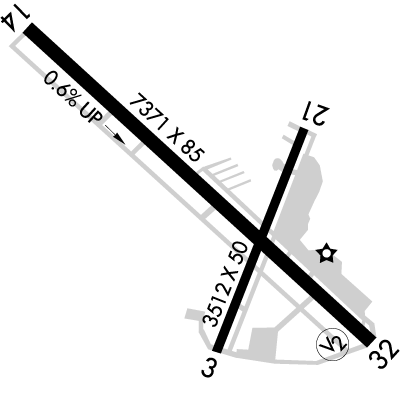
Runway 14/32
Dimensions:
7,345 × 85 ft
(2,239 × 26 m)
(2,239 × 26 m)
Weight Bearing Cap:
n/a
Surface:
asphalt, no surface treatment, in good condition
Runway Edge Lights:
Non-standard
Comments:
Rwy 14/32 First 575 Ft At Approach End of Runway 32 85 Ft Wide; Remainder Rwy 14/32 100 Ft Wide
FAA
Rwy 14/32 Nstd Mirls; Rwy 32 Thld Lgts Ntsd.
FAA
| Designator: | 14 | 32 |
| Elevation: | 109.9 ft | 152.6 ft |
| Heading: | 144° magnetic 132° true | 324° magnetic 312° true |
| Gradient: | 0.58% up | 0.58% down |
| Traffic Pattern: | Left Pattern | Left Pattern |
| Markings: | precision, in Good condition | non-standard, in Good condition |
| Approach Lighting: |
| n/a |
| Displaced Threshold: | n/a | n/a |
| ILS/LOC: | LOC/DME | n/a |
| Obstructions: | Trees, 243 ft Left ft of center, 30 ft high, 807 ft from end, 20:1 clearance slope | Trees, Both-Sides, 27 ft high, 774 ft from end, 20:1 clearance slope |
| Comments: | Obstn Clnc Slope 20:1 to Threshold FAA | Obstn Clnc Slope 20:1 to Threshold FAA |
Runway 03/21
Dimensions:
3,508 × 50 ft
(1,069 × 15 m)
(1,069 × 15 m)
Weight Bearing Cap:
n/a
Surface:
asphalt, no surface treatment, in fair condition
Runway Edge Lights:
n/a
Comments:
Rwy 03/21 Clsd to Acft Over 12500 Lbs.
FAA
| Designator: | 03 | 21 |
| Elevation: | 148.7 ft | 146.9 ft |
| Heading: | 034° magnetic 022° true | 214° magnetic 202° true |
| Gradient: | 0.05% down | 0.05% up |
| Traffic Pattern: | Left Pattern | Left Pattern |
| Markings: | basic, in Fair condition | basic, in Fair condition |
| Approach Lighting: | n/a | n/a |
| Displaced Threshold: | n/a | n/a |
| ILS/LOC: | n/a | n/a |
| Obstructions: | Trees, Both-Sides, 43 ft high, 473 ft from end, 6:1 clearance slope | Tree, 75 ft Right ft of center, 29 ft high, 210 ft from end |
| Comments: | +15 Ft Tree 138 Ft Fm Rwy End 13 Ft R Cntrln. FAA | Rwy 21 32 Ft Pole/Bldg 60 Ft from Thld, 70 Ft Left. FAA |
TFRs
Location: BLM
Please verify all content below using the FAA TFR Search Site or with a flight briefer.
TFR count: 0
NOTAMs
Location: BLM
Please verify all content below using the FAA NOTAM Search Site or with a flight briefer.
NOTAM count: 11 (Partial list shown. Expand to see full list HERE.)
| Number: | Start Date: (UTC) | End Date: (UTC) | Condition: |
|---|---|---|---|
| 03/001 | 03/03/2025 1622 | 03/03/2026 2359 | TWY ALL NORTH OF RWY 14/32 CLSD TO ACFT MORE THAN 12500LB |
| 4/6152 | 03/12/2024 1412 | IAP MONMOUTH EXEC, BELMAR/FARMINGDALE, NJ.
VOR-A, AMDT 3D...
DME REQUIRED EXCEPT FOR ACFT EQUIPPED WITH SUIT… | |
| 04/026 | 04/29/2025 1734 | 05/15/2025 1400 | SVC AUTOMATED WX BCST SYSTEM U/S |
| 04/003 | 04/09/2025 1546 | 07/08/2025 0400 | OBST TOWER LGT (ASR 1211466) 400749.30N0740717.40W (3.4NM S BLM) 393.0FT (287.1FT AGL) U/S |
| 02/014 | 02/11/2025 1954 | 05/12/2025 2359 | OBST TOWER LGT (ASN 2022-AEA-4051-OE) 401234N0740214W (4.2NM ENE BLM) 218FT (185FT AGL) U/S |
| 02/021 | 02/17/2025 1517 | 05/18/2025 0500 | OBST TOWER LGT (ASR 1047335) 401310.00N0740309.00W (3.9NM ENE BLM) 312.0FT (211.9FT AGL) U/S |
| 03/011 | 03/21/2025 0412 | 05/05/2025 0411 | OBST TOWER LGT (ASR 1231692) 401610.40N0740417.50W (5.6NM NNE BLM) 304.1FT (204.1FT AGL) U/S |
| 04/002 | 04/01/2025 1100 | 06/30/2025 0400 | OBST TOWER LGT (ASR 1046073) 401915.90N0740749.90W (8.1NM N BLM) 485.9FT (419.0FT AGL) U/S |
Additional Remarks
All Tsnt Acft Must Go to FBO on West Side of Arpt.
Source:
FAA
Federal Aviation Administration
Berm 36 Ft High; North Ry 14/32 65 Ft from Cntrln.
Source:
FAA
Federal Aviation Administration
Deer & Birds on & In vicinity of Arpt.
Source:
FAA
Federal Aviation Administration
For Clearance Delivery Contact Mc Guire Approach Via Freq, If Una Call 609-754-2767.
Source:
FAA
Federal Aviation Administration
No Helicopter Activity Northeast of Ry 14. Helicopter Instruction by Pre-Arrangement Only 732-938-4800.
Source:
FAA
Federal Aviation Administration
No Touch & Go Landings Fri; Sat; Sun.
Source:
FAA
Federal Aviation Administration
Ry 14/32 Non-Std Twy Separation 185 Ft.
Source:
FAA
Federal Aviation Administration
Twys Nstd Markings. Ry Hold Markings on Twys Nstd Placement. Twy Lines Do not Ensure Wing Tip/Rotor Clearance At Northwest End of Parallel Twy.
Source:
FAA
Federal Aviation Administration
Noise Abatement
Instrument Procedures
Operations & More Information
Lat/Long:
- 40.18678, -74.12456
- 40° 11′ 12.4″ N, 74° 7′ 28.4″ W
- 40° 11.207′ N, 74° 7.473′ W
ARTCC:
New York (ZNY)
App/Depart Control Facility:
WRI
Chart:
NACO: New York Sectional
FSS:
Millville (MIV)
1-800-WX-BRIEF
1-800-WX-BRIEF
Wind Indicator:
Lighted
Mag Var:
12W (1985)
NOTAM Facility:
Seg Circle:
No
Beacon:
Present
Lighting:
No lighting reported.
Pattern Altitude:
No data provided. Assume 1000 AGL.
Special Operations:
Communications Card
| Type: | Frequency / Phone: | Sector / Comments: | Call Sign: |
|---|---|---|---|
| Approach/Departure | 126.475 | Mc Guire | |
| AWOS-3PT | 121.625T (732) 938-3330 | ||
| Clearance Delivery | 126.15 | Mc Guire | |
| CTAF | 123.0 | ||
| UNICOM | 123.0 |
Navaids
Services
Fuel:
100LL Low-Lead, Jet A
AM
Engine Repair:
Minor
AM
Airframe Repair:
Minor
AM
Bottled Oxygen:
None
Bulk Oxygen:
None
Customs:
None
Transportation:
Courtesy Transportation, Limousine
AM
Activities:
Intensive Flight Training
AM
Camping On Field:
None Reported
Aircraft & Activity
Webcams
METARs
TAFs
Contact Addresses
Airport Manager
Alan Antaki
Farmingdale, NJ 07727
(732) 751-0044 (Office)
Owner
Wall Aviation
Farmingdale, NJ 07727
(732) 938-4800 (Office)
Airport Reviews
Overall:
1 rating | 5 reviews
Runways and Taxiways:No ratings
Markings and Signage:No ratings
Ground Transportation:No ratings
Sort By:
- 8/29/19Gerarde M.Paving on taxiways and ramp is of intermittent quality. The smaller runway has some unsettling paving inconsistencies (area where it looks like concrete was used to patch asphalt, for example) and I wouldn't expect a smooth ride on there. The main ru…
- 8/20/14MARK M.Flew with a friend (Bob D.) to Belmar for lunch on Wednesday August 6, 2014. Pretty big airport with good runways. The restaurant, Runway 34, is literally across the street from the FBO and has pretty good food and outside seating where you can watch…
- 10/3/16CHAD W.I just hung up with Jody at the Monmouth Jet Center, and she couldn't have been nicer! I will be in / out of there a couple times the next few days, but I don't expect any problems based on Jody's willingness to help arrange transportation.
- 12/11/14MARTIN H.This airport and the FBO are not GA friendly, and that is why there is such little activity except for the flight schools - who want to assist but the owners have ordered them not to. Possibly the most unhelpful and argumentative staff I have ever e…
- 5/4/13KEN W.Flew in here with my sister for some lunch and was not disappointed. The guys at Columbia came out and ushered us into a parking spot and chocked the wheels for us. Paid the $11 service fee and was good to go. The Runway 34 Restaurant is within walki…